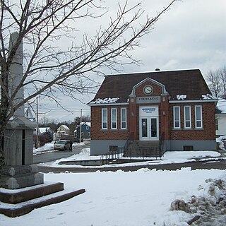
Stewiacke is a town located in southern Colchester County, Nova Scotia, Canada. The town was incorporated on August 30, 1906.

Cape Breton Regional Municipality is the Canadian province of Nova Scotia's second largest municipality and the economic heart of Cape Breton Island. As of 2016 the municipality has a population of 94,285. The municipality was created in 1995 through the amalgamation of eight municipalities located in Cape Breton County.

Digby is an incorporated town in southwestern Nova Scotia, Canada. It is in the historical county of Digby and a separate municipality from the Municipality of the District of Digby. The town is situated on the western shore of the Annapolis Basin near the entrance to the Digby Gut, which connects the basin to the Bay of Fundy.
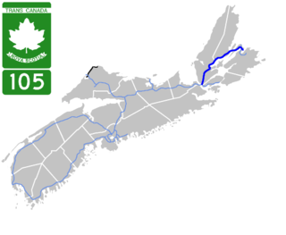
Highway 105 in Nova Scotia represents the Cape Breton Island leg of the Trans-Canada Highway. It runs from the Port Hastings Rotary just east of the Canso Causeway in Port Hastings to the Marine Atlantic ferry terminal in North Sydney, representing a distance of 142 kilometres (88 mi).
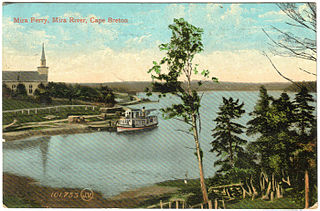
The Mira River is a Canadian river located in eastern Cape Breton Island, Nova Scotia.

The Eastern Shore is a region of the Canadian province of Nova Scotia. It is the Atlantic coast running northeast from Halifax Harbour to the eastern end of the peninsula at the Strait of Canso.
Sheet Harbour is a rural community in Nova Scotia, Canada. It is located in the eastern reaches of the Halifax Regional Municipality, approximately 117 km (73 mi) northeast of the central urban area of the municipality, concentrated on Downtown Halifax and Dartmouth. The community is located along the Marine Drive scenic route on Trunk 7 at its junctions with Route 224 and Route 374. Surrounding the branched harbour which its name is derived from, the community has a population of about 800 and its respective census tract, containing sizable amounts of land around the community, has a population of 3,478 as of the 2011 Census. Two rivers, West River and East River, flow through the community and into the Northwest and Northeast Arms of the harbour respectively. The coastline of the community is heavily eroded and the region in which the community is located has an abundance of lakes. The region has a humid continental climate, congruent with the majority of Nova Scotia, and the ocean significantly influences the temperature.
The Bras d'Or Lakes Scenic Drive is a scenic roadway on Nova Scotia's Cape Breton Island. It extends around the perimeter of Bras d'Or Lake.

Nova Scotia is a province located in Eastern Canada fronting the Atlantic Ocean. One of the Maritime Provinces, Nova Scotia's geography is complex, despite its relatively small size in comparison to other Canadian provinces.

Cape Chignecto Provincial Park is a Canadian provincial park located in Nova Scotia. A wilderness park, it derives its name from Cape Chignecto, a prominent headland which divides the Bay of Fundy with Chignecto Bay to the north and the Minas Channel leading to the Minas Basin to the east. The park, which opened in 1998, is the largest provincial park in Nova Scotia. It also anchors one end of the UNESCO Cliffs of Fundy Global Geopark.
Cape John is an unincorporated area in the Canadian province of Nova Scotia, located in Pictou County. It is situated on a cape, bordered by the Northumberland Strait to the north and John Bay, the estuary of the River John, to the south.
Groves Point is a community in the Canadian province of Nova Scotia, located in the Cape Breton Regional Municipality.
Indian Fields, Nova Scotia is an unincorporated community and provincial park reserve in the Municipality of the District of Shelburne, Nova Scotia, Canada, on Route 203 at an elevation of about 70m. There is an area of meadows. The few households that make up the community are not serviced by Nova Scotia Power. There is an abandoned airfield near the junction of Indian Fields Road and Route 203.

Uisge Ban Falls is a waterfall near Baddeck, Nova Scotia, Canada. The falls is located in Uisge Ban Falls Provincial Park near New Glen, Victoria County, 14.5 kilometres north of Baddeck.
Uisge Ban Falls Provincial Park is a provincial park near New Glen, in the Canadian province of Nova Scotia on Cape Breton Island. Located on the North Branch Road 14.5 kilometres (9.0 mi) north of Baddeck, the civic address of the park entrance is 715 North Branch Road, Baddeck Forks, Nova Scotia, Canada B0E 1B0.

Ben Eoin Provincial Park is a small secluded provincial park on an old farm against hardwood-covered hills in the community of Ben Eoin, Nova Scotia, Canada, on the south side of the East Bay of the Bras d'Or Lake, on Cape Breton Island. This picnic and hiking park is managed by the provincial Department of Natural Resources and is situated on a heavily wooded 225 acres (91 ha) parcel of Crown land. A short distance into the park there are several large neatly mown clearings with picnic tables under the trees at the edge of the small fields. Pit toilets and disposal areas for hot coals are available onsite.

East Bay is a bay of the Bras d'Or Lake on Cape Breton Island in the Canadian province of Nova Scotia. It lies entirely within Cape Breton County.

Cabots Landing Provincial Park is a small picnic and beach park on the shore of Aspy Bay in the community of Sugarloaf, 10 kilometres (6.2 mi) north of the Cabot Trail on Cape Breton Island, Nova Scotia, Canada.
St. Patricks Channel is an arm of the Bras d'Or Lake located on Cape Breton Island, in the Canadian province of Nova Scotia. St. Patricks Channel lies entirely within Victoria County.
Jerry Lawrence Provincial Park is a provincial park in the Canadian province of Nova Scotia, in Upper Tanatallon. It is located on Route 3, approximately 25 kilometres west of Halifax.
