
Cumbria is a ceremonial county in North West England. It borders the Scottish council areas of Dumfries and Galloway and Scottish Borders to the north, Northumberland and County Durham to the east, North Yorkshire to the south-east, Lancashire to the south, and the Irish Sea to the west. Its largest settlement is the city of Carlisle.

Ulverston is a market town and civil parish in Westmorland and Furness, Cumbria, England. In the 2001 census the parish had a population of 11,524, increasing at the 2011 census to 11,678. Historically in Lancashire, it lies a few miles south of the Lake District National Park and just north-west of Morecambe Bay, within the Furness Peninsula. Lancaster is 39 miles (63 km) to the east, Barrow-in-Furness 10 miles (16 km) to the south-west and Kendal 25 miles (40 km) to the north-east.

Millom is a town and civil parish on the north shore of the estuary of the River Duddon in southernmost Cumberland, Cumbria, England. It is situated just outside the Lake District National Park, about six miles north of Barrow-in-Furness and 26 mi (42 km) south of Whitehaven.

Kendal, once Kirkby in Kendal or Kirkby Kendal, is a market town and civil parish in the Westmorland and Furness district of Cumbria, England. It lies within the River Kent's dale, from which its name is derived, just outside the boundary of the Lake District National Park.

Barrow-in-Furness is a port town and civil parish in the Westmorland and Furness district, in the ceremonial county of Cumbria, England. Historically in Lancashire, it was incorporated as a municipal borough in 1867 and merged with Dalton-in-Furness Urban District in 1974 to form the Borough of Barrow-in-Furness. In 2023, the borough merged with Eden and South Lakeland districts to form a new unitary authority: Westmorland and Furness. At the tip of the Furness peninsula, close to the Lake District, it is bordered by Morecambe Bay, the Duddon Estuary and the Irish Sea. In 2021, Barrow's population was 55,489, making it the second largest urban area in Cumbria after Carlisle, and the largest in the Westmorland and Furness unitary authority.
Grange-over-Sands is a town and civil parish located on the north side of Morecambe Bay in Cumbria, England, a few miles south of the Lake District National Park. In the 2001 census the parish had a population of 4,042, increasing at the 2011 census to 4,114. Within the boundaries of the historic county of Lancashire, the town was created as an urban district in 1894. Though the town remains part of the Duchy of Lancaster, since 2023 it has been administered as part of the Westmorland and Furness Council area.

Barrow-in-Furness was a local government district with borough status in Cumbria, England. It was named after its main town, Barrow-in-Furness. Other settlements included Dalton-in-Furness and Askam-in-Furness. It was the smallest district in Cumbria, but the most densely populated, with 924 people per square kilometre. The population was 71,980 in 2001, reducing to 69,087 at the 2011 Census.

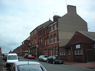
Dalton-in-Furness is a town and former civil parish, now in the parish of Dalton Town with Newton, in the Westmorland and Furness district, in the ceremonial county of Cumbria, England. In 2011 it had a population of 7,827. It is located 4 miles (6 km) north east of Barrow-in-Furness.

A civil parish in England is the lowest unit of local government. There are 284 civil parishes in the ceremonial county of Cumbria, with most of the county being parished. At the 2001 census, there were 359,692 people living in those 284 parishes, accounting for 73.8 per cent of the county's population.
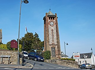
Broughton in Furness is a market town in the civil parish of Broughton West in the Westmorland and Furness district of Cumbria, England. It had a population of 529 at the 2011 Census. It is located on the south western boundary of England's Lake District National Park, and in the Furness region, which is within the historic boundaries of Lancashire.

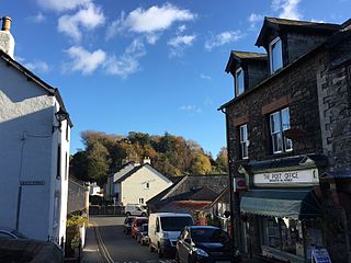
Lindal-in-Furness is a village on the Furness peninsula, in the Westmorland and Furness district of Cumbria, England. Historically in Lancashire, it lies eight miles to the north-east of Barrow-in-Furness, on the A590 trunk road. The civil parish is Lindal and Marton which had a population of 755 at the 2011 Census.

Dalton Castle is a grade I listed 14th-century peel tower situated in Dalton-in-Furness, Cumbria, England, and in the ownership of the National Trust. It was constructed by the monks of Furness Abbey for the protection of the nearby market town, and was the building from which the Abbot administered the area and dispensed justice.

Newton is a village in the civil parish of Dalton Town with Newton, in the Westmorland and Furness district, in the ceremonial county of Cumbria, England. It is located on the Furness peninsula north-east of the port of Barrow-in-Furness and south of the town of Dalton-in-Furness.
Hawcoat is an area and electoral ward of Barrow-in-Furness, Cumbria, England. Historically part of Lancashire, it is one of Barrow's most northerly wards and is bordered by Roose, Newbarns, Parkside, Ormsgill and the town of Dalton-in-Furness to the north.

Askam and Ireleth is a civil parish close to Barrow-in-Furness in Westmorland and Furness, Cumbria, England. Historically part of Lancashire, it originally consisted of two separate coastal villages with different origins and histories which, in recent times, have merged to become one continuous settlement. In the 2001 census the parish had a population of 3,632, reducing at the 2011 census to 3,462.
Hindpool is an area and electoral ward of Barrow-in-Furness, Cumbria, England. It is bordered by Barrow Island, Central Barrow, Ormsgill, Parkside and the Walney Channel, the local population stood at 5,851 in 2011. The ward covers the entire western half of the town centre and includes Barrow's main shopping district. Other local landmarks include the Furness College Channelside campus, the Dock Museum and the Main Public Library. Hindpool is also home to two stadia - Barrow Raiders' Craven Park and Barrow A.F.C.'s Holker Street.

Barrow-in-Furness Main Public Library is a Grade II listed Beaux-Arts style building located at Ramsden Square, Barrow-in-Furness, England. Operated since 1974 by Cumbria County Council, it is the largest library in the town and the present structure, designed by J A Charles was originally built as a Carnegie library with support from the Carnegie Foundation.

St Mary's Church is in the town of Dalton-in-Furness, Cumbria, England. It is an active Anglican parish church in the deanery of Furness, the archdeaconry of Westmorland and Furness, and the diocese of Carlisle. Its benefice has been combined with that of St Peter, Ireleth-with-Askam. The church is recorded in the National Heritage List for England as a designated Grade II* listed building. It stands in an elevated position near Dalton Castle.

Lindale and Newton-in-Cartmel, formerly Upper Allithwaite is a civil parish in the Westmorland and Furness district, in the ceremonial county of Cumbria, England. The spelling Lindale and Newton in Cartmel, without hyphens, is used by the parish council.

