Dampier Strait (Papua New Guinea)

Last updated

Dampier Strait
Dampier Strait NASA.jpg
Dampier Strait seen from space. Also visible are Umboi Island (west), New Britain (east) and Sakar Island (north). (false colors)
Papua New Guinea relief map.svg
Red pog.svg
Dampier Strait
Coordinates 5°36′S148°12′E / 5.6°S 148.2°E / -5.6; 148.2 Coordinates: 5°36′S148°12′E / 5.6°S 148.2°E / -5.6; 148.2
Type strait
Dampier Strait Papua New Guinea location map showing Dampier Strait.jpg
Dampier Strait

Dampier Strait in Papua New Guinea separates Umboi Island and New Britain, linking the Bismarck Sea to the north with the deeper Solomon Sea to the south.

Contents

History

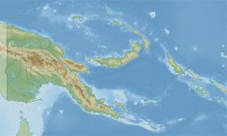
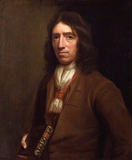
The strait is named after the first European to sail through it, British navigator William Dampier in 1700 in HMS Roebuck. Dampier described his discoveries in his A Continuation of a Voyage to New Holland Ch. 4 New Britain Discovered in these terms:

NEW BRITAIN.

The easternmost part of New Guinea lies 40 miles to the westward of this tract of land, and by hydrographers they are made joining together: but here I found an opening and passage between, with many islands; the largest of which lie on the north side of this passage or strait. The channel is very good, between the islands and the land to the eastward. ... As we stood over to the islands we looked out very well to the north, but could see no land that way; by which I was well assured that we were got through, and that this east land does not join to New Guinea; therefore I named it New Britain. The north-west cape I called Cape Gloucester, and the south-west point Cape Anne; and the north-west mountain, which is very remarkable, I called Mount Gloucester.

...

SIR GEORGE ROOK'S ISLAND.

Being near the island to the northward of the volcano I sent my boat to sound, thinking to anchor here; but she returned and brought me word that they had no ground, till they met with a reef of coral rocks about a mile from the shore. Then I bore away to the north side of the island where we found no anchoring neither. We saw several people, and some coconut-trees, but could not send ashore for want of my pinnace which was out of order. In the evening I stood off to sea to be at such a distance that I might not be driven by any current upon the shoals of this island if it should prove calm. We had but little wind, especially the beginning of the night; but in the morning I found myself so far to the west of the island that, the wind being at east-south-east, I could not fetch it; wherefore I kept on to the southward and stemmed with the body of a high island about 11 or 12 leagues long, lying to the southward of that which I before designed for. I named this island Sir George Rook's Island.

LONG ISLAND AND CROWN ISLAND, DISCOVERED AND DESCRIBED.

We also saw some other islands to the westward; which may be better seen in my chart of these lands than here described. But, seeing a very small island lying to the north-west of the long island which was before us, and not far from it, I steered away for that; hoping to find anchoring there: and, having but little wind, I sent my boat before to sound; which, when we were about 2 miles distance from the shore, came on board and brought me word that there was good anchoring in 30 or 40 fathom water, a mile from the isle and within a reef of the rocks which lay in a half-moon, reaching from the north part of the island to the south-east: so at noon we got in and anchored in 36 fathom a mile from the isle.

In the afternoon I sent my boat ashore to the island to see what convenience there was to haul our vessel ashore in order to be mended, and whether we could catch any fish. My men in the boat rowed about the island, but could not land by reason of the rocks and a great surge running in upon the shore. We found variation here 8 degrees 25 minutes west.

I designed to have stayed among these islands till I had got my pinnace refitted; but, having no more than one man who had skill to work upon her, I saw she would be a long time in repairing (which was one great reason why I could not prosecute my discoveries further) and, the easterly winds being set in, I found I should scarce be able to hold my ground.

The 31st in the forenoon we shot in between 2 islands lying about 4 leagues asunder; with intention to pass between them. The southernmost is a long island with a high hill at each end; this I named Long island. The northernmost is a round high island towering up with several heads or tops, something resembling a crown; this I named Crown Isle from its form. Both these islands appeared very pleasant, having spots of green savannahs mixed among the woodland: the trees appeared very green and flourishing, and some of them looked white and full of blossoms. We passed close by Crown Isle; saw many coconut-trees on the bays and the sides of the hills; and one boat was coming off from the shore but returned again. We saw no smokes on either of the islands, neither did we see any plantations; and it is probable they are not very well peopled. We saw many shoals near Crown Island, and reefs of rocks running off from the points a mile or more into the sea. My boat was once overboard with design to have sent her ashore; but, having little wind and seeing some shoals, I hoisted her in again and stood off out of danger.

Annexations and World Wars

After the (British) Imperial annulment of the 1883 annexation by the Queensland colonial government of New Guinea east of the Dutch boundary at 141 E, in 1884 Germany "annexed the northern shore of New Guinea from the Dutch boundary east-ward to Dampier Strait and the territory back of it theoretically to the crest of the central range of mountains." [1] In so doing it changed the name of the New Britannia Archipelago to the Bismarck Archipelago. [2]

On the outbreak of World War I in 1914, the armed forces of Australia took, among other German possessions, the Bismarck Archipelago and, after a few month's fighting, German New Guinea. [3] The Treaty of Versailles created a League of Nations mandate over this area administratively vested in Australia.

On 8 March 1942, the Japanese landed two battalions at Lae and Salamaua on the Huon Gulf giving them control of the Dampier and Vitiaz Straits. [4] In December 1943 American forces landed on New Britain. [5] General Douglas MacArthur announced that Rooke Island (Umboi Island) had been occupied on 12 February 1944 by American forces who met no opposition: [6] [7] Company B, 1st Marines had crossed the Dampier Strait on landing craft. [8]

Related Research Articles

New Britain Island in Papua New Guinea

New Britain is the largest island in the Bismarck Archipelago, part of the Islands Region of Papua New Guinea. It is separated from New Guinea by a northwest corner of the Solomon Sea and from New Ireland by St. George's Channel. The main towns of New Britain are Rabaul/Kokopo and Kimbe. The island is roughly the size of Taiwan. While the island was part of German New Guinea, it was named Neupommern . In common with most of the Bismarcks it was largely formed by volcanic processes, and has active volcanoes including Ulawun, Langila, the Garbuna Group, the Sulu Range, and the volcanoes Tavurvur and Vulcan of the Rabaul caldera. A major eruption of Tavurvur in 1994 destroyed the East New Britain provincial capital of Rabaul. Most of the town still lies under metres of ash, and the capital has been moved to nearby Kokopo.

Bismarck Archipelago Archipelago in northeast Papua New Guinea

The Bismarck Archipelago is a group of islands off the northeastern coast of New Guinea in the western Pacific Ocean and is part of the Islands Region of Papua New Guinea. Its area is about 50,000 square km.

William Dampier British scientist, pirate and explorer (1651–1715)

William Dampier was an English explorer, pirate, privateer, navigator, and naturalist who became the first Englishman to explore parts of what is today Australia, and the first person to circumnavigate the world three times. He has also been described as Australia's first natural historian, as well as one of the most important British explorers of the period between Francis Drake and James Cook, he "bridged those two eras" with a mix of piratical derring-do of the former and scientific inquiry of the later. His expeditions were among the first to identify and name a number of plants, animals, foods, and cooking techniques for a European audience; being among the first English writers to use words such as avocado, barbecue, and chopsticks. In describing the preparation of avocados, he was the first European to describe the making of guacamole, named the breadfruit plant, and made frequent documentation of the taste of numerous foods foreign to the European palate such as flamingo and manatee.

Tweed River (New South Wales) River in northern New South Wales, Australia

The Tweed River is a river situated in the Northern Rivers district of New South Wales, Australia. From the middle reaches of its course, the state boundary between New South Wales and Queensland is located approximately 10 kilometres (6.2 mi) north.

Bismarck Sea Marginal sea of the Pacific Ocean

The Bismarck Sea lies in the southwestern Pacific Ocean within the nation of Papua New Guinea. It is located northeast of the island of New Guinea and south of the Bismarck Archipelago. It has coastlines in districts of the Islands Region, Momase Region, and Papua Region.

USS <i>Beale</i> (DD-471) Fletcher-class destroyer

USS Beale (DD/DDE-471), a Fletcher-class destroyer, was the second ship of the United States Navy to be named for Lieutenant Edward Fitzgerald Beale (1822–1893).

Vitiaz Strait Strait in Papua New Guinea

Vitiaz Strait is a strait between New Britain and the Huon Peninsula, northern New Guinea.

HMS <i>Lady Nelson</i> (1798) Australian survey vessel

His Majesty's Armed Survey Vessel Lady Nelson was commissioned in 1799 to survey the coast of Australia. At the time large parts of the Australian coast were unmapped and Britain had claimed only part of the continent. The British Government were concerned that, in the event of settlers of another European power becoming established in Australia, any future conflict in Europe would lead to a widening of the conflict into the southern hemisphere to the detriment of the trade that Britain sought to develop. It was against this background that Lady Nelson was chosen to survey and establish sovereignty over strategic parts of the continent.

SS <i>Princess Sophia</i>

SS Princess Sophia was a steel-built passenger liner in the coastal service fleet of the Canadian Pacific Railway (CPR). Along with SS Princess Adelaide, SS Princess Alice, and SS Princess Mary, Princess Sophia was one of four similar ships built for CPR during 1910-1911.

Battle of Cape Gloucester WWII battle in the Pacific Theater

The Battle of Cape Gloucester was fought in the Pacific theater of World War II between Japanese and Allied forces on the island of New Britain, Territory of New Guinea, between 26 December 1943 and 16 January 1944. Codenamed Operation Backhander, the US landing formed part of the wider Operation Cartwheel, the main Allied strategy in the South West Pacific Area and Pacific Ocean Areas during 1943–1944. It was the second landing the US 1st Marine Division had conducted during the war thus far, after Guadalcanal. The objective of the operation was to capture the two Japanese airfields near Cape Gloucester that were defended by elements of the Japanese 17th Division.

Umboi Island

Umboi is a volcanic island between the mainland of Papua New Guinea and the island of New Britain. It is separated from New Britain by the Dampier Strait and Huon Peninsula, and New Guinea by the Vitiaz Strait. It has an elevation of 1,335 metres.

John Daniel was an English sea captain who, in the ship New London, charted part of the coast of Western Australia in 1681. Daniel and the New London are believed to have been the second group of English mariners to sight the mainland of Australia, after the Tryall was wrecked in 1620.

HMS <i>Roebuck</i> (1690) Fifth-rate warship of the Royal Navy

HMS Roebuck was a fifth-rate warship in the Royal Navy which, under the command of William Dampier, carried the first British scientific expedition to Australia in 1699. The wreck of the ship has since been located by a team from the Western Australian Maritime Museum at a site on the coast of Ascension Island where it foundered more than 300 years ago.

Rock of Ages Light Lighthouse in Michigan, United States

The Rock of Ages Light is a U.S. Coast Guard lighthouse on a small rock outcropping approximately 2.25 miles (3.62 km) west of Washington Island and 3.5 miles (5.6 km) west of Isle Royale, in Eagle Harbor Township, Keweenaw County, Michigan. It is an active aid to navigation.

Saumarez Reefs Lighthouse

Saumarez Reef is one of the southernmost reefs to be located in the Coral Sea Islands and part of the Coral Sea Shelf; it contains three main reefs and numerous smaller reefs all of which form a large crescent-shaped formation open to the northwest, about 27 by 14 km, area less than 300 km2.

Kelanoa Harbour is a harbour on the north coast of the Huon Peninsula in Papua New Guinea serving the town of Kelanoa. It is a large bay with an impenetrable reef and a small island.

Abraham Bristow (c1771-1846) was a British mariner, sealer and whaler. In August 1806 he discovered the Auckland Islands.

On the morning of March 13, 1888, an explosion took place on Ritter Island, a small volcanic island in the Bismarck and Solomon Seas, between New Britain and Umboi Island. This event is the largest volcanic island sector collapse in recent history.

Omba Island is an island of Indonesia. It was written about by William Dampier in A Continuation of a Voyage to New Holland (1699):

That afternoon we saw the opening between the islands Omba and Fetter, but feared to pass through in the night. At two o'clock in the morning it fell calm; and continued so till noon, in which time we drove with the current back again south-west six or seven leagues. On the 22nd, steering to the eastward to get through between Omba and Fetter, we met a very strong tide against us, so that we, although we had a very fresh gale, yet made way very slowly; yet before night got through. By a good observation we found that the south-east point of Omba lies in latitude 8 degrees 25 minutes. In my charts it is laid down in 8 degrees 10 minutes. My true course from Babao is east 25 degrees north, distance one hundred and eighty-three miles. We sounded several times when near Omba, but had no ground. On the north-east point of Omba we saw four or five men, and a little further three pretty houses on a low point, but did not go ashore.

References

  1. William Churchill, 'Germany's Lost Pacific Empire' (1920) Geographical Review 10 (2) pp84-90 at p84 and p87
  2. William Churchill, 'Germany's Lost Pacific Empire' (1920) Geographical Review 10 (2) pp84-90 at p84
  3. William Churchill, 'Germany's Lost Pacific Empire' (1920) Geographical Review 10 (2) pp84-90 at p89
  4. 'New Guinea campaign' in I. C. B. Dear and M. R. D. Foot (eds) (2001) The Oxford Companion to World War II
  5. John Coates 'New Guinea Campaign' in Peter Dennis, Jeffrey Grey, Ewan Morris, Robin Prior and Jean Bou (eds) (2009) The Oxford Companion Australian Military History
  6. 'U.S. Troops Seize Vitiaz Strait Isle' The New York Times 15 Feb 1944 p6
  7. Frank Dexter 'Rooke Island Occupied' The Argus (Melbourne, Victoria) Wed 16 Feb 1944 p16
  8. Bernard C. Nalty, 'The Mopping-up Begins in the West', Cape Gloucester: The Green Inferno