
Bramhope is a village and civil parish in the City of Leeds metropolitan borough, West Yorkshire, England, north of Holt Park and north east of Cookridge.

East Farndon is a small linear village and civil parish about one mile south of Market Harborough in West Northamptonshire, England. The village is close to the border with Leicestershire, and has a Leicestershire post code and telephone dialling code. At the time of the 2001 census, the parish's population was 258 people, increasing to 307 at the 2011 census.

Box is a large village and civil parish within the Cotswolds Area of Outstanding Natural Beauty in Wiltshire, England, about 3 miles (5 km) west of Corsham and 5 miles (8 km) northeast of Bath. Box also falls in the easternmost part of the Avon Green Belt. Besides the village of Box, the parish includes the villages of Ashley and Box Hill; Hazelbury manor; and the hamlets of Alcombe, Blue Vein, Chapel Plaister, Ditteridge, Henley, Kingsdown, Middlehill, and Wadswick. To the east the parish includes much of Rudloe, formerly a hamlet but now a housing estate, and the defence establishments and related businesses on the site of the former RAF Rudloe Manor.

Dunham Massey is a civil parish in the Metropolitan Borough of Trafford, Greater Manchester, England. The parish includes the villages of Sinderland Green, Dunham Woodhouses and Dunham Town, along with Dunham Massey Hall and Park, formerly the home of the last Earl of Stamford and owned by the National Trust since 1976. Dunham Massey is in the historic county of Cheshire, but since 1974 has been part of Trafford Metropolitan Borough; the nearest town is Altrincham. At the 2001 census, the parish had a population of 475.

Bishop's Sutton or Bishop's Sutton is a village and civil parish one mile (1.6 km) east of the market town of Alresford in the City of Winchester district of Hampshire, England. According to the 2001 census it had a population of 419, increasing to 463 at the 2011 Census.

Hatherton is a hamlet and civil parish in the unitary authority of Cheshire East and the ceremonial county of Cheshire, England. The hamlet is on the B5071 at SJ687474, 2+3⁄4 miles (4.4 km) to the north east of Audlem and 3+3⁄4 miles (6.0 km) to the south east of Nantwich. The civil parish has an area of 673 hectares and also includes the small settlements of Birchall Moss, Broomlands and part of Artlebrook, with a total population of 360 in 2011. Nearby villages include Hankelow, Stapeley, Walgherton, Wybunbury, Blakenhall and Buerton. The A529 runs through the parish and the River Weaver forms the western boundary.

Minshull Vernon is a hamlet and civil parish in the unitary authority of Cheshire East and the ceremonial county of Cheshire, England. The hamlet lies 3 miles (5 km) to the north west of Crewe, south east of Winsford and south west of Middlewich. The parish also includes the small settlements of Bradfield Green, Eardswick, Hoolgrave, Minshull Hill, Walley's Green and Weaver Bank. The total population of the civil parish is somewhat over 200, measured at 391 in the Census 2011. Nearby villages include Church Minshull, Warmingham and Wimboldsley.

Stanford Rivers is a village and civil parish in the Epping Forest district of Essex, England. The parish, which is approximately 11 miles (18 km) west from the county town of Chelmsford, contains the village of Toot Hill and the hamlet of Little End, both settlements larger than Stanford Rivers village, and the hamlet of Clatterford End. The village is 2.0 miles (3 km) south-east of Chipping Ongar, 3 miles (5 km) south-west of North Weald Bassett and 3 miles north-west of Kelvedon Hatch. The parish covers an area of 1,749 hectares.

Wood Street Village is a clustered and linear village in Surrey, England with a village green, buffered by Metropolitan Green Belt on all sides. It is centred 3 miles (4.8 km) west of Guildford and is part of the civil parish of Worplesdon, as well as continuing to be served semi-dependently as a chapelry of the Church of England.

As of 2011 there were 102 listed buildings and structures in the English borough of Crawley, West Sussex. Two others have subsequently gained listed status. The Borough of Crawley is based on the town of the same name, located approximately halfway between London and Brighton. Although Crawley expanded substantially after World War II when it was designated a New Town by an Act of Parliament, many older buildings remain.

Runcorn is an industrial town in the borough of Halton, Cheshire, England. This list contains the 27 buildings that are recorded in the National Heritage List for England as designated listed buildings in the part of the borough lying to the south of the River Mersey outside the urban area of Runcorn. The area covered includes the villages of Clifton, Daresbury, Preston Brook, Preston on the Hill, and Moore. Three of the buildings in the area are classified as Grade II*, and the others are at Grade II; there are no buildings in Grade I. In the United Kingdom, the term listed building refers to a building or other structure officially designated as being of special architectural, historical, or cultural significance. These buildings are in three grades: Grade I consists of buildings of outstanding architectural or historical interest; Grade II* includes particularly significant buildings of more than local interest; Grade II consists of buildings of special architectural or historical interest. Buildings in England are listed by the Secretary of State for Culture, Media and Sport on recommendations provided by English Heritage, which also determines the grading.

Sutton Mandeville is a small village and civil parish in Wiltshire, England, in the Nadder valley and towards the east end of the Vale of Wardour. The village lies south of the river and north of the A30 Shaftesbury-Wilton road, about 7 miles (11 km) west of Wilton and 2.5 miles (4 km) east of the large village of Tisbury.

In the English civil parish of Lymm, there are 55 buildings that are recorded in the National Heritage List for England as designated listed buildings. Of these, one is classified as Grade I and one as Grade II*; the remainder are at Grade II. Lymm is in the borough of Warrington and the ceremonial county of Cheshire. In the early 16th century, the civil parish was a prosperous agricultural area, divided into two manors, Lymm and Oughtrington. The Grade-II*-listed Lymm Hall, the oldest listed building in the civil parish, dates from the late 16th century and occupies the site of a medieval building which was the manorial seat. The largest settlement in the civil parish is Lymm, which has expanded into a small town whilst retaining its village centre. Several other small settlements within the parish remain separate, including Oughtrington; Oughtrington Hall dates from around 1810.
Astley is a settlement in the Metropolitan Borough of Wigan in Greater Manchester, England. Originally a village, it now forms a continuous urban area with Tyldesley to the north. It lies on flat land north of Chat Moss and is crossed by the Bridgewater Canal and the A580 "East Lancashire Road". Astley contains several listed buildings designated by English Heritage and included in the National Heritage List for England. Most are listed at Grade II, the lowest of the three gradings given to listed buildings and is applied to "buildings of national importance and special interest".
Goosnargh is a civil parish in the City of Preston, Lancashire, England. It contains 49 listed buildings that are recorded in the National Heritage List for England. Of these, four are at Grade II*, the middle grade, and the others are at Grade II, the lowest grade. The parish contains the villages of Inglewhite and Whitechapel, and part of the village of Goosnargh, but is otherwise completely rural. The listed buildings are mainly houses and associated structures, farmhouses, and farm buildings. The other listed buildings include churches, cross bases, sundials, a public house, and a school.
Knightsland Farm House is a Grade II* listed farmhouse in South Mimms in Hertfordshire, England. It dates from the 16th century, with later additions, and is timber-framed with a brick casing. The associated barn is also Grade II* listed.
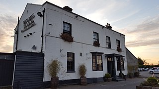
The Green Dragon is a Grade II listed public house in St Albans Road, Dancers Hill, Hertfordshire, England, on the road north from Chipping Barnet. It dates from around 1830 and is built of brick with a slate roof.
Dancers Hill House is a Grade II listed house in Dancers Hill, Hertfordshire, England. The current house dates from c. 1750–1760, with later additions, and was probably built for Charles Ross, a Westminster builder, who leased 10 acres from David Hechstetter Jr. for 80 years in 1750. The grotto north-east of the house is also Grade II listed.
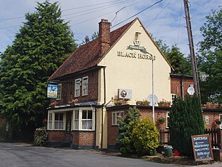
The Black Horse is a Grade II listed public house on Blackhorse Lane in South Mimms, Hertfordshire, England.
Trysull and Seisdon is a civil parish in the district of South Staffordshire, Staffordshire, England. It contains 22 listed buildings that are recorded in the National Heritage List for England. Of these, one is at Grade II*, the middle of the three grades, and the others are at Grade II, the lowest grade. The parish contains the villages of Trysull and Seisdon and the surrounding countryside. All the listed buildings are in the villages, apart from a lock on the Staffordshire and Worcestershire Canal and a bridge crossing it. Most of the listed buildings are houses, cottages, farmhouses and farm buildings, the earlier of which are timber framed. The other listed buildings include a church, a public house, two road bridges, two mills, and a war memorial.
