
The Choctaw are a Native American people originally based in the Southeastern Woodlands, in what is now Alabama and Mississippi. Their Choctaw language is a Western Muskogean language. Today, Choctaw people are enrolled in three federally recognized tribes: the Choctaw Nation of Oklahoma, Mississippi Band of Choctaw Indians, and Jena Band of Choctaw Indians in Louisiana.
The Trail of Tears was an ethnic cleansing and forced displacement of approximately 60,000 people of the "Five Civilized Tribes" between 1830 and 1850 by the United States government. As part of the Indian removal, members of the Cherokee, Muscogee (Creek), Seminole, Chickasaw, and Choctaw nations were forcibly removed from their ancestral homelands in the Southeastern United States to newly designated Indian Territory west of the Mississippi River after the passage of the Indian Removal Act in 1830. The Cherokee removal in 1838 was brought on by the discovery of gold near Dahlonega, Georgia, in 1828, resulting in the Georgia Gold Rush.

Macon is a city in Noxubee County, Mississippi along the Noxubee River. The population was 2,768 at the 2010 census. It is the county seat of Noxubee County.

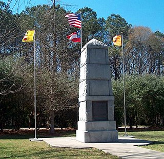
The Treaty of Dancing Rabbit Creek was a treaty which was signed on September 27, 1830, and proclaimed on February 24, 1831, between the Choctaw American Indian tribe and the United States Government. This treaty was the first removal treaty which was carried into effect under the Indian Removal Act. The treaty ceded about 11 million acres (45,000 km2) of the Choctaw Nation in what is now Mississippi in exchange for about 15 million acres (61,000 km2) in the Indian territory, now the state of Oklahoma. The principal Choctaw negotiators were Chief Greenwood LeFlore, Mosholatubbee, and Nittucachee; the U.S. negotiators were Colonel John Coffee and Secretary of War John Eaton.

Greenwood LeFlore or Greenwood Le Fleur served as the elected Principal Chief of the Choctaw in 1830 before removal. Before that, the nation was governed by three district chiefs and a council of chiefs. A wealthy and regionally influential Choctaw of mixed-race, who belonged to the Choctaw elite due to his mother's rank, LeFlore had many connections in state and federal government. In 1830 LeFlore led other chiefs in signing the Treaty of Dancing Rabbit Creek, which ceded the remaining Choctaw lands in Mississippi to the US government and agreed to removal to Indian Territory. It also provided that Choctaw who chose to stay in Mississippi would have reserved lands, but the United States government failed to follow through on this provision.

The Choctaw Nation of Oklahoma is a Native American territory covering about 6,952,960 acres, occupying portions of southeastern Oklahoma in the United States. The Choctaw Nation is the third-largest federally recognized tribe in the United States and the second-largest Indian reservation in area after the Navajo. As of 2011, the tribe has 223,279 enrolled members, of whom 84,670 live within the state of Oklahoma and 41,616 live within the Choctaw Nation's jurisdiction. A total of 233,126 people live within these boundaries, with its tribal jurisdictional area comprising 10.5 counties in the state, with the seat of government being located in Durant, Oklahoma. It shares borders with the reservations of the Chickasaw, Muscogee, and Cherokee, as well as the U.S. states of Texas and Arkansas. By area, the Choctaw Nation is larger than eight U.S. states.

Mushulatubbee was the chief of the Choctaw Okla Tannap, one of the three major Choctaw divisions during the early 19th century. When the Principal Chief Greenwood LeFlore stayed in Mississippi at the time of removal, Mushulatubbee was elected as principal chief, leading the tribe to Indian Territory.
The Mississippi Band of Choctaw Indians is one of three federally recognized tribes of Choctaw people, and the only one in the state of Mississippi. On April 20, 1945, this tribe organized under the Indian Reorganization Act of 1934. Their reservation included lands in Neshoba, Leake, Newton, Scott, Jones, Attala, Kemper, and Winston counties. The Mississippi Choctaw regained stewardship of their mother mound, Nanih Waiya mounds and cave in 2008. The Mississippi Band of Choctaw have declared August 18 as a tribal holiday to celebrate their regaining control of the sacred site. The other two Choctaw groups are the Choctaw Nation of Oklahoma, the third largest tribe in the United States, and the Jena Band of Choctaw Indians, located in Louisiana.

Nanih Waiya is an ancient platform mound in southern Winston County, Mississippi, constructed by indigenous people during the Middle Woodland period, about 300 to 600 CE. Since the 17th century, the Choctaw and Chickasaw have venerated Nanih Waiya mound and a nearby cave as their sacred origin location.

Choctaw Country is the Oklahoma Department of Tourism and Recreation's official tourism designation for Southeastern Oklahoma. The name was previously Kiamichi Country until changed in honor of the Choctaw Nation headquartered there. The current definition of Choctaw Country includes ten counties, being Coal, Atoka, Bryan, Choctaw, McCurtain, Pushmataha, Le Flore, Latimer, Haskell, and Pittsburg counties. The department created the term as one of six designated travel regions within the state. However, other definitions of Southeastern Oklahoma may include additional counties.

The Treaty of Doak's Stand was signed on October 18, 1820 between the United States and the Choctaw Indian tribe. Based on the terms of the accord, the Choctaw agreed to give up approximately one-half of their remaining Choctaw homeland. In October 1820, Andrew Jackson and Thomas Hinds were sent as commissioners who represented the United States to negotiate a treaty to surrender a large portion of Choctaw country in Mississippi. They met with tribal representatives at Doak's Stand on the Natchez Trace. They met with the chiefs Pushmataha, Mushulatubbee, and Apuckshunubbee, who represented the three major regional divisions of the Choctaw. Chiefs of the towns and other prominent men accompanied them, such as Colonel Silas Dinsmoor.

Creek National Capitol, also known as Creek Council House, is a building in downtown Okmulgee, Oklahoma, in the United States. It was capitol of the Muscogee (Creek) Nation from 1878 until 1907. They had established their capital at Okmulgee in 1867, after the American Civil War.
Fort Washita is the former United States military post and National Historic Landmark located in Durant, Oklahoma on SH 199. Established in 1842 by General Zachary Taylor to protect citizens of the Choctaw and Chickasaw Nations from the Plains Indians, it was later abandoned by Federal forces at the beginning of the American Civil War. Confederate troops held the post until the end of the war when they burned the remaining structures. It was never reoccupied by the United States military. After years in private hands the Oklahoma Historical Society bought the fort grounds in 1962 and restored the site. In 2017, the Chickasaw Nation purchased Fort Washita from the Oklahoma Historical Society and assumed responsibility for the site and its management. Today, Fort Washita is a tourist attraction and hosts several events throughout the year. In August 2023, the Fort Washita Historic Site was placed into federal trust with the U.S. government.

The Masonic Hall of Hiram Masonic Lodge No. 7 is a historic Gothic revival building on South 2nd Avenue in Franklin, Tennessee. Constructed in 1823, it is the oldest public building in Franklin. It is nationally significant as the site of negotiations leading to the Treaty of Franklin, the first Indian removal treaty agreed after passage of the 1830 Indian Removal Act. It was declared a National Historic Landmark in 1973. It continues to serve the local Masonic lodge.
Apuckshunubbee was one of three principal chiefs of the Choctaw Native American tribe in the early nineteenth century, from before 1800. He led the western or Okla Falaya District of the Choctaw, of which the eastern edge ran roughly southeast from modern Winston County to Lauderdale County, then roughly southwest to Scott County, then roughly south-southeast to the western edge of Perry County. His contemporaries were Pushmataha and Moshulatubbee, who respectively led the southern district Okla Hannali and the north-eastern district Okla Tannap.

The Choctaw Trail of Tears was the attempted ethnic cleansing and relocation by the United States government of the Choctaw Nation from their country, referred to now as the Deep South, to lands west of the Mississippi River in Indian Territory in the 1830s by the United States government. A Choctaw Miko (chief) was quoted by the Arkansas Gazette as saying that the removal was a "trail of tears and death." Since removal, the Choctaw have developed since the 20th century as three federally recognized tribes: the largest, the Choctaw Nation of Oklahoma; the Mississippi Band of Choctaw Indians, and the Jena Band of Choctaw Indians in Louisiana.
United States v. John, 437 U.S. 634 (1978), was a case in which the Supreme Court of the United States held that lands designated as a reservation in Mississippi are "Indian country" as defined by statute, although the reservation was established nearly a century after Indian removal and related treaties. The court ruled that, under the Major Crimes Act, the State has no jurisdiction to try a Native American for crimes covered by that act that occurred on reservation land.

The Treaty of Pontotoc Creek was a treaty signed on October 20, 1832 by representatives of the United States and the Chiefs of the Chickasaw Nation assembled at the National Council House on Pontotoc Creek in Pontotoc, Mississippi. The treaty ceded the 6,283,804 million acres of the remaining Chickasaw homeland in Mississippi in return for Chickasaw relocation on an equal amount of land west of the Mississippi River.
The History of the Choctaws, or Chahtas, are a Native American people originally from the Southeast of what is currently known as the United States. They are known for their rapid post-colonial adoption of a written language, transitioning to yeoman farming methods, and having European-American and African-Americans lifestyles enforced in their society.


