Related Research Articles

Tamworth is a city and administrative centre of the north-western region of New South Wales, Australia. Situated on the Peel River within the local government area of the Tamworth Regional Council, it is the largest and most populated city in the region, with a population of 43,874 in 2021, making it the second largest inland city in New South Wales. Tamworth is 318 km (198 mi) from the Queensland border and is located almost midway between Brisbane and Sydney.

New England is a geographical region in the north of the state of New South Wales, Australia, about 60 km inland from the Tasman Sea. The area includes the Northern Tablelands and the North West Slopes regions. As of 2021, New England had a population of 185,560, with over a quarter of the people living in the area of Tamworth Regional Council.

Oxley Highway is a rural highway in New South Wales, Australia, linking Nevertire, Gilgandra, Coonabarabran, Tamworth, and Walcha to Port Macquarie, on the coast of the Tasman Sea. It was named to commemorate John Oxley, the first European to explore much of inland New South Wales in 1818.
Macdonald River, a perennial river that is part of the Namoi catchment within the Murray–Darling basin, is located in the Northern Tablelands district of New South Wales, Australia.
Dundas is a suburb of Sydney, New South Wales, Australia. Dundas is located 21 kilometres north-west of the Sydney central business district, in the local government area of the City of Parramatta, and the electoral division of Bennelong. Dundas is a leafy green suburb, notably due to its centrepiece The Ponds Walk, which follows the Ponds Subiaco Creek. Dundas is part of the Northern Sydney and Greater Western Sydney regions.
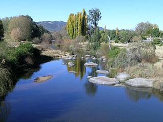
Kootingal is a town in New South Wales, Australia in the Tamworth Regional Council area. It is commonly called a satellite suburb of Tamworth because of its closeness and the fact that its residents use Tamworth's services. Founded as an Aboriginal mission, Kootingal traces its name roots to the local Aboriginal Kamilaroi language. At the 2021 census, Kootingal had a population of 2,313 people.

Moonbi is a village situated on the New England Highway 20 kilometres north of Tamworth, New South Wales, Australia. It is nestled at the foot of the Moonbi Range and is part of the Tamworth Regional Council local government area. Moonbi is located a few kilometres to the north of the town of Kootingal. At the 2006 census, Moonbi had a population of 357 people.
The Moonbi Range, a mountain range that is part of the Great Dividing Range, is located in the Northern Tablelands of New South Wales, Australia.

The Northern Tablelands, also known as the New England Tableland, is a plateau and a region of the Great Dividing Range in northern New South Wales, Australia. It includes the New England Range, the narrow highlands area of the New England region, stretching from the Moonbi Range in the south to the Queensland border in the north. The region corresponds generally to the Bureau of Meteorology forecast area for the Northern Tablelands which in this case includes Inverell although it is significantly lower in elevation.

Tascott is a suburb of the Central Coast region of New South Wales, Australia between Gosford and Woy Woy on Brisbane Water's western shore. It is part of the Central Coast Council local government area.
Group 4 is a rugby league competition in the New England and north west area of New South Wales, run under the auspices of the Country Rugby League.

Tamworth Regional Council is a local government area in the New England region of New South Wales, Australia. The area under administration is located adjacent to the New England Highway and the Main North railway line. It was established in March 2004 through the amalgamation of the former City of Tamworth with surrounding shires of Barraba, Manilla, Nundle and Parry.

Inglis County is one of the 141 Cadastral divisions of New South Wales. It contains Tamworth and Bendemeer.

Parry County is one of the 141 Cadastral divisions of New South Wales. It is bounded by the Peel River and Cockburn River on the north, near Tamworth. The Moonbi Range is on the eastern boundary, and the Peel Range on the western boundary. The Great Dividing Range is the boundary to the south-east. It includes the towns of Dungowan, Ogunbil, Woolomin, Loomberah, Piallamore and Nundle.

St James Parish, Cumberland is one of the 57 parishes of Cumberland County, New South Wales, a cadastral unit for use on land titles. It is one of the four small parishes in the Sydney city area, which is named after the Anglican church of St James, which was consecrated in 1824. The name St James is also used today for the railway station in the same area.
St Philip Parish is one of the 57 parishes of Cumberland County, New South Wales, a cadastral unit for use on land titles. It is located on the western part of the original colony at Sydney Cove, which was to the west of the Tank Stream. It is one of the four small parishes in the Sydney city area and is named after the church of St Philip's. It includes the southern end of the Sydney Harbour Bridge, The Rocks, Dawes Point and Millers Point. It is bounded by Sydney Harbour in the north, King Street in the south, George Street in the south-east, and what was once the Tank Stream in the east. The northern end of Darling Harbour is the boundary in the west. It includes Wynyard railway station.

Bendemeer is a village of 485 people on the Macdonald River in the New England region of New South Wales, Australia. It is situated at the junction of the New England and Oxley Highways.

Cockburn River is a perennial river that is part of the Namoi catchment within the Murray–Darling basin, located in the Northern Tablelands district of New South Wales, Australia.
Himberrong is a clan of the Anēwan Aboriginal tribe of what is now known as the New England Tablelands region in northeast New South Wales. Part of their traditional land, once an Aboriginal reserve called Inglebah, is now a heritage Aboriginal Place.
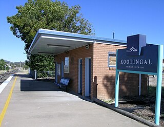
Kootingal railway station is located on the Main Northern line in New South Wales, Australia. It serves the town of Kootingal, opening on 9 January 1882 as Moonbi when the line was extended from West Tamworth. It was the terminus of the line until it was extended to Uralla on 2 August 1882. It was renamed Kootingal on 20 April 1914. Opposite the station lies a passing loop.
References
- ↑ http://trove.nla.gov.au/work/32530067?selectedversion=NBD42138475 1934, English, Map, Single map edition: Parish of Danglemah, County of Inglis [cartographic material] : Land District of Tamworth, Cockburn Shire, Eastern Division N.S.W. / compiled, drawn & printed at the Department of Lands, Sydney, N.S.W. ] New South Wales. Dept. of Lands1934.
- ↑ Map of Danglemah, NSW at Bonzle.com.
- ↑ "Travel:Bendemeer". Sydney Morning Herald. 15 August 2007. Retrieved 10 November 2007.
- ↑ Danglemah Station NSWrail.net, accessed 16 January 2010.
| Preceding station | Former Services | Following station | ||
|---|---|---|---|---|
| Woolbrook towards Wallangarra | Main North Line | Limbri towards Sydney | ||