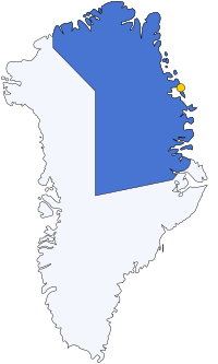
Danmarkshavn (Denmark's Harbour) is a small weather station located in Dove Bay, on the northeastern shore of the Germania Land Peninsula, in Northeast Greenland National Park, Greenland.
Danmarkshavn (Denmark's Harbour) is a small weather station located in Dove Bay, on the northeastern shore of the Germania Land Peninsula, in Northeast Greenland National Park, Greenland.
The location was chosen as a suitable winter harbor by the Denmark expedition in 1906 for their ship Danmark. It became the main base of the expedition, from where sledge journeys and scientific observations were carried out. [1]
The permanent population of the base is six. Danmarkshavn is also known as the northernmost location on the coast of the Greenland Sea that non-icebreaking vessels can pass through. Therefore, it is resupplied by cargo ship in August every other year; thus the population increases somewhat for a brief time every other August. The ice situation varies, and some years it is not possible to reach the station, other years it is ice-free further north. It is operated by TELE-POST Greenland, a telecommunications company. [2] Danmarkshavn has a short airstrip ( ICAO : BGDH).
The station is jointly funded by countries that have ratified the Agreement on the Joint Financing of Certain Air Navigation Services In Greenland. [3]
 |
Danmarkshavn has a cold tundra climate (Köppen climate classification ET), and hence it has long, cold winters. July and August are the warmest months, with average temperatures just a few degrees above freezing.
| Climate data for Danmarkshavn (normals 1991-2020, extremes 1958-2020) | |||||||||||||
|---|---|---|---|---|---|---|---|---|---|---|---|---|---|
| Month | Jan | Feb | Mar | Apr | May | Jun | Jul | Aug | Sep | Oct | Nov | Dec | Year |
| Record high °C (°F) | 4.5 (40.1) | 2.1 (35.8) | 0.3 (32.5) | 3.8 (38.8) | 11.8 (53.2) | 17.1 (62.8) | 19.8 (67.6) | 19.7 (67.5) | 8.6 (47.5) | 4.8 (40.6) | 2.4 (36.3) | 3.8 (38.8) | 19.8 (67.6) |
| Average high °C (°F) | −17.2 (1.0) | −18.0 (−0.4) | −18.3 (−0.9) | −11.8 (10.8) | −3.4 (25.9) | 4.4 (39.9) | 7.7 (45.9) | 6.0 (42.8) | −0.7 (30.7) | −9.1 (15.6) | −13.6 (7.5) | −16.6 (2.1) | −7.5 (18.4) |
| Daily mean °C (°F) | −21.4 (−6.5) | −22.2 (−8.0) | −22.2 (−8.0) | −15.9 (3.4) | −6.4 (20.5) | 1.5 (34.7) | 4.4 (39.9) | 3.2 (37.8) | −2.8 (27.0) | −11.9 (10.6) | −17.2 (1.0) | −20.6 (−5.1) | −11.0 (12.3) |
| Average low °C (°F) | −25.8 (−14.4) | −26.9 (−16.4) | −27.0 (−16.6) | −21.1 (−6.0) | −9.9 (14.2) | −1.3 (29.7) | 1.3 (34.3) | 0.3 (32.5) | −5.4 (22.3) | −14.8 (5.4) | −20.8 (−5.4) | −24.9 (−12.8) | −14.7 (5.6) |
| Record low °C (°F) | −44.4 (−47.9) | −43.6 (−46.5) | −45.0 (−49.0) | −39.3 (−38.7) | −26.0 (−14.8) | −12.8 (9.0) | −7.0 (19.4) | −8.2 (17.2) | −17.6 (0.3) | −31.0 (−23.8) | −36.3 (−33.3) | −41.1 (−42.0) | −45.0 (−49.0) |
| Average precipitation mm (inches) | 30.9 (1.22) | 21.0 (0.83) | 21.0 (0.83) | 13.2 (0.52) | 7.7 (0.30) | 4.1 (0.16) | 13.6 (0.54) | 20.9 (0.82) | 19.7 (0.78) | 17.7 (0.70) | 19.1 (0.75) | 20.8 (0.82) | 209.7 (8.27) |
| Average precipitation days (≥ 1.0 mm) | 5.1 | 4.3 | 4.6 | 3.2 | 1.9 | 1.1 | 3.0 | 3.5 | 3.6 | 3.8 | 4.2 | 4.3 | 42.6 |
| Average relative humidity (%) | 71.9 | 69.0 | 68.9 | 69.0 | 76.9 | 77.7 | 77.5 | 76.6 | 72.7 | 71.4 | 69.5 | 68.4 | 72.5 |
| Mean monthly sunshine hours | 0 | 11 | 131 | 274 | 368 | 341 | 376 | 272 | 168 | 67 | 0 | 0 | 2,008 |
| Percent possible sunshine | 0.0 | 11.1 | 37.1 | 47.5 | 49.5 | 47.4 | 50.5 | 39.1 | 39.7 | 31.0 | 0.0 | 0.0 | 29.4 |
| Source: Danish Meteorological Institute [4] [5] [6] [7] | |||||||||||||

Greenland is located between the Arctic Ocean and the North Atlantic Ocean, northeast of Canada and northwest of Iceland. The territory comprises the island of Greenland—the largest island in the world—and more than a hundred other smaller islands. Greenland has a 1.2 kilometre long border with Canada on Hans Island. A sparse population is confined to small settlements along certain sectors of the coast. Greenland possesses the world's second-largest ice sheet.

Ellesmere Island is Canada's northernmost and third largest island, and the tenth largest in the world. It comprises an area of 196,236 km2 (75,767 sq mi), slightly smaller than Great Britain, and the total length of the island is 830 km (520 mi).

Upernavik is a small town in the Avannaata municipality in northwestern Greenland, located on a small island of the same name. With 1,092 inhabitants as of 2020, it is the twelfth-largest town in Greenland. It contains the Upernavik Museum.

Qaanaaq, formerly known as Thule or New Thule, is the main town in the northern part of the Avannaata municipality in northwestern Greenland. It is one of the northernmost towns in the world. The inhabitants of Qaanaaq speak the local Inuktun language and many also speak Kalaallisut and Danish. The town has a population of 646 as of 2020. The population was forcibly relocated from its former, traditional home, which was expropriated for the construction of a United States Air Force base in 1953.

Ilulissat, formerly Jakobshavn or Jacobshaven, is the municipal seat and largest town of the Avannaata municipality in western Greenland, located approximately 350 km (220 mi) north of the Arctic Circle. With the population of 4,670 as of 2020, it is the third-largest city in Greenland, after Nuuk and Sisimiut. The city is home to almost as many sled-dogs as people.

Pituffik Space Base, formerly Thule Air Base, is the United States Space Force's northernmost base, and the northernmost installation of the U.S. Armed Forces, located 750 mi (1,210 km) north of the Arctic Circle and 947 mi (1,524 km) from the North Pole on the northwest coast of the island of Greenland. Pituffik's Arctic environment includes icebergs in North Star Bay, two islands, a polar ice sheet, and Wolstenholme Fjord – the only place on Earth where four active glaciers join together. The base is home to a substantial portion of the global network of missile warning sensors of Space Delta 4, and space surveillance and space control sensors of Space Delta 2, providing space awareness and advanced missile detection capabilities to North American Aerospace Defense Command (NORAD), the United States Space Force, and joint partners.

Ludvig Mylius-Erichsen was a Danish author, ethnologist, and explorer, from Ringkøbing. He was most notably an explorer of Greenland.

Tasiilaq, formerly Ammassalik and Angmagssalik, is a town in the Sermersooq municipality in southeastern Greenland. With 1,985 inhabitants as of 2020, it is the most populous community on the eastern coast, and the seventh-largest town in Greenland. The Sermilik Station, dedicated to the research of the nearby Mittivakkat Glacier, is located near the town.

Paamiut, formerly Frederikshåb, is a town in southwestern Greenland in the Sermersooq municipality.

Ittoqqortoormiit, formerly known as Scoresbysund, is a settlement in the Sermersooq municipality in eastern Greenland. Its population was 345 as of 2020 and has been described as one of the most remote settlements on earth.

The Danish Meteorological Institute is the official Danish meteorological institute, administrated by the Ministry of Energy, Utilities and Climate. It makes weather forecasts and observations for Denmark, Greenland, and the Faroe Islands.

The climate of the Arctic is characterized by long, cold winters and short, cool summers. There is a large amount of variability in climate across the Arctic, but all regions experience extremes of solar radiation in both summer and winter. Some parts of the Arctic are covered by ice year-round, and nearly all parts of the Arctic experience long periods with some form of ice on the surface.

Germania Land or Germanialand is a peninsula in northeastern Greenland. Despite the high latitude it is largely unglaciated.

Greenland's climate is a tundra climate on and near the coasts and an ice cap climate in inland areas. It typically has short, cool summers and long, moderately cold winters.

Hovgaard Island is a large uninhabited island of the Greenland Sea, Greenland. The island was named after Andreas Hovgaard, a Polar explorer and officer of the Danish Navy who led an expedition to the Kara Sea on steamship Dijmphna in 1882–83.

King Frederick VIII Land is a major geographic division of northeastern Greenland. It extends above the Arctic Circle from 76°N to 81°N in a N/S direction along the coast of the Greenland Sea.

The Denmark expedition, also known as the Denmark Expedition to Greenland's Northeast Coast, and as the Danmark Expedition after the ship, was an expedition to the northeast of Greenland in 1906–1908. Despite being overshadowed by the death in tragic circumstances of the main exploration team, including three of the expedition's leading members: Ludvig Mylius-Erichsen (1872–1907), Niels Peter Høeg Hagen (1877–1907) and Jørgen Brønlund (1877–1907), the Denmark expedition was not a failure. It achieved its main cartographic objectives and succeeded in exploring the vast region, drawing accurate charts of formerly unexplored coastlines and fjords, naming numerous geographic features, and gathering a wealth of scientific data.
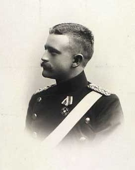
Niels Peter Høeg Hagen was a Danish military officer, polar explorer and cartographer. He participated and perished in the ill-fated Denmark expedition to NE Greenland in 1906.

The bark Danmark is best known for her role as expedition ship for the Danmark expedition (1906–08), so named after the ship, but had a long prehistory as a whaler under the name Sir Colin Campbell of Peterhead and later as a sealer named Magdalena of Tønsberg/Kristiana.