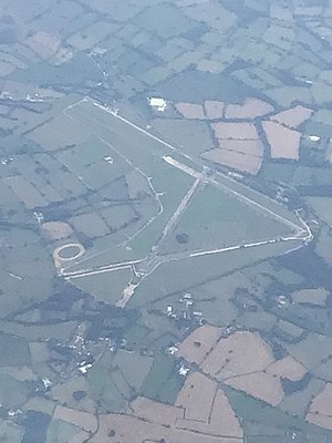
A race track is a facility built for racing of vehicles, athletes, or animals. A race track also may feature grandstands or concourses. Race tracks are also used in the study of animal locomotion.
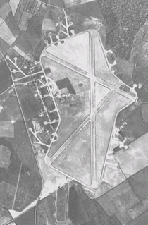
Royal Air Force Station Silverstone or more simply RAF Silverstone is a former Royal Air Force (RAF) station, the site is now used as Silverstone Circuit. It straddles the Northamptonshire and Buckinghamshire border and is named after the nearby village of Silverstone. It is 10 miles (16 km) south west of Northampton, 11.1 miles (17.9 km) west of Milton Keynes, Buckinghamshire and 13.9 miles (22.4 km) east of Banbury, Oxfordshire, England and was opened in 1943 during the Second World War.

Castle Donington is a market town and civil parish in Leicestershire, England, on the edge of the National Forest and close to East Midlands Airport.

The Waltham transmitting station is a broadcasting and telecommunications facility at Waltham-on-the-Wolds, 5 miles (8 km) north-east of Melton Mowbray. It sits inside the Waltham civil parish near Stonesby, in the district of Melton, Leicestershire, UK. It has a 315 metres (1,033 ft) guyed steel tubular mast. The main structure height to the top of the steelwork is 290.8 metres (954 ft), with the UHF television antennas contained within a GRP shroud mounted on top.

Airways Airsports is an airpark at Darley Moor Airfield, Derbyshire, offering hang gliding, paragliding, paramotoring and microlight training and flying. It is a British Hang Gliding and Paragliding Association and British Microlight Aircraft Association (BMAA) recognised school. Instructors include a three-times world champion, world record holders, British cross country champion, British distance record holder, Royal Aeroclub gold medal winner and members of the British hang gliding and paragliding team.
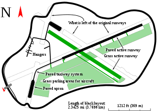
The Thruxton Circuit is a 2.356 mi (3.792 km) motor-racing circuit located near the village of Thruxton in Hampshire, England which hosts motorsport events including British Touring Cars and Formula 3 racing. It is often referred to as the "Fastest Circuit in the UK" where drivers can reach speeds of over 190 mph (300 km/h) and has earned the reputation of being a true driver's track. To illustrate this, Damon Hill drove his Williams Formula One car around the circuit at an average speed of 147 mph (237 km/h) in 1993.
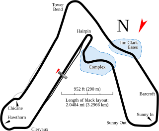
Croft Circuit is a motor racing circuit located near Dalton-on-Tees in North Yorkshire, England. The tarmac circuit is 2.127 mi (3.423 km) long and is based on the lands of an airfield, but has long since moved on from being a basic airfield circuit. The circuit holds meetings of the British Touring Car Championship, British Rallycross and Pickup Truck Racing race series.

Royal Air Force Davidstow or more commonly RAF Davidstow Moor is a former Royal Air Force station located 2.9 miles (4.7 km) north east of Camelford, Cornwall and 11.5 miles (18.5 km) west of Launceston, Cornwall, England.
Darley or Darly may refer to:
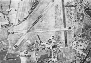
Royal Air Force Snetterton Heath or more simply RAF Snetterton Heath is a former Royal Air Force station located south east of the A11, 6 miles (9.7 km) south west of Attleborough, Norfolk, England.

Royal Air Force Ouston, or more simply RAF Ouston, is a former Royal Air Force station that was located near the village of Stamfordham and the village of Heddon-on-the-Wall on Hadrian's Wall near Newcastle upon Tyne. It was built as a Second World War aerodrome and is today used by the British Army. Just north of the airfield is Richmond Hill, Northumberland, in the parish of Stamfordham.
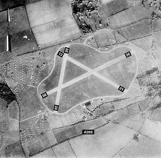
Royal Air Force Thruxton or more simply RAF Thruxton is a former Royal Air Force station located 5 miles (8.0 km) west of Andover, Hampshire and about 66 miles (106 km) southwest of London.

Royal Air Force Merryfield or more simply RAF Merryfield is a former Royal Air Force station in the village of Ilton near Ilminster in southwest Somerset, England. The airfield is located approximately 7 miles (11 km) north of Chard, about 130 miles (210 km) southwest of London. It is now RNAS Merryfield and serves as a satellite to the larger RNAS Yeovilton; it is used mainly as a training facility for helicopter pilots.

Royal Air Force Fersfield or more simply RAF Fersfield is a former Royal Air Force station located 16 miles (26 km) southwest of Norwich, Norfolk, England.
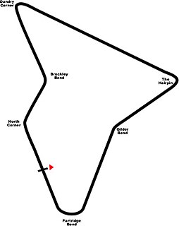
Lulsgate Aerodrome was a motor racing circuit at the former RAF Lulsgate Bottom airfield, which in 1957 subsequently became Bristol Airport. The airfield was turned into a racing circuit in 1949. Lulsgate hosted two race meetings, in 1949 and 1950. The circuit mainly hosted sports car events, however a Formula III race featured in both 1949 and 1950.
The Thruxton 500 was a motorcycle endurance race for production based road machines, covering 500 miles and ridden by a team of two riders per machine. The first event was a 9-hour race which took place in 1955, organized by the Southampton and District Motorcycle Club (SDMCC) at the Thruxton Circuit near Andover in Hampshire. Two more 9-hour races followed in 1956 and 1957.
RAF Ashbourne is a former Royal Air Force airfield located approximately 1.5 miles (2.4 km) south-east of the town of Ashbourne, Derbyshire, England.

Royal Air Force Charterhall or more simply RAF Charterhall is a former Royal Air Force station located in the Scottish Borders and the historic county of Berwickshire between the village of Greenlaw and Duns. It was originally a First World War landing ground named Eccles Toft. The airfield was reconstructed in 1942 and was used mainly by No. 54 Operational Training Unit during Second World War. The RAF left in 1947 and the airfield was officially closed.

Steve Henshaw was an English professional motorcycle racer and working motorcycle mechanic.
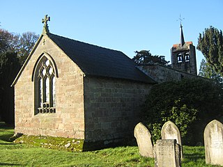
Edlaston and Wyaston is a civil parish within the Derbyshire Dales district, in the county of Derbyshire, England. The parish includes the villages of Edlaston and Wyaston. In 2011 the parish had a population of 220. It is 120 miles (190 km) north west of London, 11 miles (18 km) north west of the county city of Derby, and 2+1⁄2 miles (4 km) south of the market town of Ashbourne. Edlaston and Wyaston touches the parishes of Clifton and Compton, Osmaston, Rodsley, Shirley, Snelston and Yeaveley. There are seven listed buildings in Edlaston and Wyaston.
