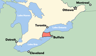
Buffalo is the second-largest city in the U.S. state of New York and the seat of Erie County. It lies in Western New York, at the eastern end of Lake Erie, at the head of the Niagara River, on the United States border with Canada. With a population of 278,349 according to the 2020 census, Buffalo is the 78th-largest city in the United States. Buffalo and the city of Niagara Falls together make up the two-county Buffalo–Niagara Falls Metropolitan Statistical Area (MSA), which had an estimated population of 1.1 million in 2020, making it the 49th largest MSA in the United States.

The Erie Canal is a historic canal in upstate New York that runs east–west between the Hudson River and Lake Erie. Completed in 1825, the canal was the first navigable waterway connecting the Atlantic Ocean to the Great Lakes, vastly reducing the costs of transporting people and goods across the Appalachians. In effect, the canal accelerated the settlement of the Great Lakes region, the westward expansion of the United States, and the economic ascendancy of New York State. It has been called "The Nation's First Superhighway."

Erie County is a county along the shore of Lake Erie in western New York State. As of the 2020 census, the population was 954,236. The county seat is Buffalo, which makes up about 28% of the county's population. Both the county and Lake Erie were named for the regional Iroquoian language-speaking Erie tribe of Native Americans, who lived in the area before 1654. They were later pushed out by the more powerful Iroquoian nations tribes.

Niagara County is in the U.S. state of New York. As of the 2020 census, the population was 212,666. The county seat is Lockport. The county name is from the Iroquois word Onguiaahra; meaning the strait or thunder of waters.

North Tonawanda is a city in Niagara County, New York, United States. The population was 31,568 at the 2010 census. It is part of the Buffalo–Niagara Falls Metropolitan Statistical Area. The city is named after Tonawanda Creek, its south border.

Wheatfield is a town in Niagara County, New York, United States. The population was 18,117 at the 2010 census. The name stems from the agricultural use of the town lands, the growing of wheat.

Niagara Falls is a city in Ontario, Canada. It is on the western bank of the Niagara River in the Golden Horseshoe region of Southern Ontario, with a population of 88,071 at the 2016 census. It is part of the St. Catharines - Niagara Census Metropolitan Area (CMA). Incorporated on 12 June 1903, the city is across the river from Niagara Falls, New York. The Niagara River flows over Niagara Falls at this location, creating a natural spectacle which attracts millions of tourists each year.

Fort Erie is a town on the Niagara River in the Niagara Region, Ontario, Canada. It is directly across the river from Buffalo, New York, and is the site of Old Fort Erie which played a prominent role in the War of 1812.

Tonawanda is a city in Erie County, New York, United States. The population was 15,129 at the 2020 census. It is at the northern edge of Erie County, south across the Erie Canal from North Tonawanda, east of Grand Island, and north of Buffalo. It is part of the Buffalo-Niagara Falls metropolitan area.
Tonawanda is a town in Erie County, New York, United States. As of the 2020 census, the town had a population of 72,636. The town is at the north border of the county and is the northern inner ring suburb of Buffalo. It is sometimes referred to, along with its constituent village of Kenmore, as "Ken-Ton". The town was established in 1836, and up to 1903 it included what is now the city of Tonawanda.
The Niagara Peninsula is an area of land lying between the southwestern shore of Lake Ontario and the northeastern shore of Lake Erie, in Ontario, Canada. Technically an isthmus rather than a peninsula, it stretches from the Niagara River in the east to Hamilton, Ontario, in the west. The peninsula is located in the Golden Horseshoe region of Southern Ontario, and has a population of roughly 1,000,000 residents. The region directly across the Niagara River and Lake Erie in New York State is known as the Niagara Frontier.

Western New York (WNY) is the westernmost region of the U.S. state of New York. The eastern boundary of the region is not consistently defined by state agencies or those who call themselves "Western New Yorkers". Almost all sources agree WNY includes the cities of Buffalo, Niagara Falls, Jamestown, and the surrounding suburbs, as well as the outlying rural areas of the Great Lakes lowlands and Niagara Frontier, and Chautauqua-Alleghany. Many would also place Rochester and the Genesee Valley in the region while some would also include the western Finger Lakes within the region. Others would describe the latter three areas as being in a separate Finger Lakes region.

East Amherst is a suburban hamlet 16 miles (26 km) northeast of downtown Buffalo, Erie County, New York, United States. It straddles the towns of Amherst and Clarence, and comprises the majority of ZIP code 14051. East Amherst also includes the headquarters of the fast food chain known as Mighty Taco.

The Railroad Museum of the Niagara Frontier is located in the 1922-built Erie Railroad freight depot in North Tonawanda, New York. Operated by the Niagara Frontier Chapter of the National Railroad Historical Society, its mission is to preserve the railroad history of the Buffalo, New York area, once the railroad hub of America. The Museum is owned by the Niagara Frontier Chapter of the National Railway Historical Society.

Buffalo is the county seat of Erie County, and the second most populous city in the U.S. state of New York, after New York City. Originating around 1789 as a small trading community inhabited by the Neutral Nation near the mouth of Buffalo Creek, the city, then a town, grew quickly after the opening of the Erie Canal in 1825, with the city at its western terminus. Its position at the eastern end of Lake Erie strengthened the economy, based on grain milling and steel production along the southern shores and in nearby Lackawanna.

The Buffalo–Niagara Falls Metropolitan Statistical Area is a metropolitan area, designated by the United States Census Bureau, encompassing two counties — Erie and Niagara in Western New York. It has a population of almost 1.2 million people. It is the second-largest metropolitan area in the state of New York, centering on the urbanized area of Buffalo.

Niagara-Wheatfield Central School District is a public school district in New York State located in the Town of Lewiston, New York, about 10 miles (16 km) from Niagara Falls, New York. The District serves students from the towns of Niagara and Wheatfield.
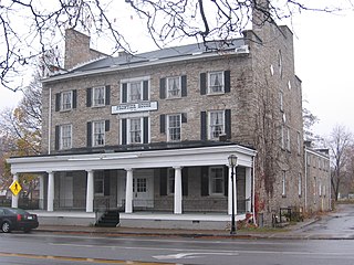
Frontier House is considered the "crown jewel" of Lewiston's historic district and one of the most historic landmarks in Western New York. In the early 1800s it was known as the finest hotel in America, west of Albany. It has been home to several Niagara County businessmen and honored guests. The building has been on the National Register of Historic Places listings in Niagara County, New York since 1974. It has served as a hotel, private home, a fine dining restaurant, museum, and a fast food establishment (McDonald's). It is found in Western New York, about ten minutes from Niagara Falls.

The Niagara Aerospace Museum is an aviation museum located in Niagara Falls, New York, in the old terminal building of the Niagara Falls International Airport. The museum has been located in a number of places in the Niagara Falls/Buffalo area. It had been located in the Niagara Office Building in downtown Niagara Falls and relocated in 2008 to the site of the then HSBC center on the waterfront in Buffalo, NY, where it was known as the Ira G. Ross Aerospace Museum. In the summer of 2013, the museum moved to its current location.

A housebarn is a building that is a combination of a house and a barn under the same roof. Most types of housebarn also have room for livestock quarters. If the living quarters are only combined with a byre, whereas the cereals are stored outside the main building, the house is called a byre-dwelling.