Dawson Springs, Kentucky

Last updated

Dawson Springs, Kentucky
Railroad Avenue in Dawson Springs.jpg
Railroad Avenue downtown (2014)
Hopkins County Kentucky Incorporated and Unincorporated areas Dawson Springs Highlighted 2120224.svg
Location within Hopkins County and Kentucky
Coordinates: 37°10′18″N87°41′21″W / 37.17167°N 87.68917°W / 37.17167; -87.68917
Country United States
State Kentucky
Counties Caldwell, Hopkins [1]
Area
[2]
  Total3.93 sq mi (10.17 km2)
  Land3.84 sq mi (9.94 km2)
  Water0.09 sq mi (0.23 km2)
Elevation
420 ft (130 m)
Population
 (2020)
  Total2,452
  Estimate 
(2022) [3]
2,420
  Density638.87/sq mi (246.70/km2)
Time zone UTC-6 (CST)
  Summer (DST) UTC-5 (CDT)
ZIP code
42408
Area code 270 & 364
FIPS code 21-20224
GNIS ID 490696
Website dawsonspringsky.com

Dawson Springs is a home rule-class city [4] in Hopkins and Caldwell counties in the U.S. state of Kentucky. As of the 2020 census, the population of the city was 2,452. [5]

Contents

History

Originally known as Tradewater Bend, the city was incorporated in 1832 under the name Dawson City by two Menser brothers.

From the late 1800s to the 1930s, Dawson Springs was well known as a spa and resort town. Visitors largely came in spring from Chicago, Louisville and points east for the curative waters, and several major hotels and boarding houses were constructed. Tourism peaked in 1901 when over 50,000 visitors came to the town of a few thousand people. The Pittsburgh Pirates held spring training there in the 1910s before being lured to St. Petersburg, Florida when the Grapefruit League formed. The advent of car travel ended the spa era as travelers began to drive to more southerly vacation spots.

Outwood Veterans Hospital was constructed here in 1922, [6] and the economy strengthened with the onset of coal mining at Dawson Daylight Mine. The town diversified with light manufacturing in the mid-20th century, but was devastated by the outflow of those industrial jobs when NAFTA was passed in the 1990s and those manufacturing jobs moved to Mexico.

Dawson Springs is still a regional tourist destination because of the Pennyrile Forest State Resort Park, which began construction where a local river was dammed and a lake formed in the 1930s. The town was named Kentucky's first Trail Town due to hiking and horse riding trails in the area.

2021 tornado

In the late hours of December 10, 2021, a large swath of the city was destroyed by an EF4 tornado, and a tornado emergency was issued for Dawson Springs and the surrounding St. Charles as the storm moved through the area. As a result, 19 people died. [7] [8]

Geography

Dawson Springs is located in southwestern Hopkins County at 37°10′18″N87°41′21″W / 37.17167°N 87.68917°W / 37.17167; -87.68917 (37.171799, -87.689190). [9] Its southern and western border is the Tradewater River, which is also the Hopkins/Caldwell County line. A small portion of Dawson Springs extends across the river into Caldwell County.

U.S. Route 62 passes through the center of the city, leading east 14 miles (23 km) to Nortonville and west 12 miles (19 km) to Princeton. Interstate 69 runs generally parallel to US 62 and touches the northern end of Dawson Springs' city limits, with access from exit 92 (Kentucky Route 109).

According to the United States Census Bureau, the city has a total area of 3.8 square miles (9.8 km2), of which 3.7 square miles (9.5 km2) is land and 0.077 square miles (0.2 km2), or 2.16%, is water. [10]

Climate

The climate in this area is characterized by hot, humid summers and generally mild to cool winters. According to the Köppen Climate Classification system, Dawson Springs has a humid subtropical climate, abbreviated "Cfa" on climate maps. [11]

Demographics

Historical population
CensusPop.Note
1890 525
1900 93578.1%
1910 1,35044.4%
1920 1,76230.5%
1930 2,31131.2%
1940 2,56010.8%
1950 2,374−7.3%
1960 3,00226.5%
1970 3,0090.2%
1980 3,2758.8%
1990 3,129−4.5%
2000 2,980−4.8%
2010 2,764−7.2%
2020 2,452−11.3%
2022 (est.)2,420 [3] −1.3%
U.S. Decennial Census

As of the census [12] of 2000, there were 2,980 people, 1,214 households, and 801 families residing in the city. The population density was 755.8 inhabitants per square mile (291.8/km2). There were 1,353 housing units at an average density of 343.2 per square mile (132.5/km2). The racial makeup of the city was 97.72% White, 0.94% African American, 0.27% Native American, 0.30% Asian, 0.07% from other races, and 0.70% from two or more races. Hispanic or Latino of any race were 0.27% of the population.

There were 1,214 households, of which 28.9% had children under the age of 18 living with them, 48.4% were married couples living together, 14.8% had a female householder with no husband present, and 34.0% were non-families. 31.2% of all households were made up of individuals, and 17.1% had someone living alone who was 65 years of age or older. The average household size was 2.31 and the average family size was 2.90.

In the city, the population was spread out, with 23.1% under the age of 18, 8.4% from 18 to 24, 25.4% from 25 to 44, 21.1% from 45 to 64, and 22.0% who were 65 years of age or older. The median age was 40 years. For every 100 females, there were 84.3 males. For every 100 females age 18 and over, there were 78.7 males.

The median income for a household in the city was $22,670, and the median income for a family was $27,872. Males had a median income of $29,545 versus $18,875 for females. The per capita income for the city was $14,649. About 25.5% of families and 27.1% of the population were below the poverty line, including 39.0% of those under age 18 and 18.9% of those age 65 or over.

Education

Dawson Springs has a lending library, a branch of the Hopkins County-Madisonville Public Library. [13] Dawson Springs also rejected the countywide school consolidation of the 1970s and maintains its own K-12 school district, which is now the town's main employer.

Notable people

Related Research Articles

<span class="mw-page-title-main">Webster County, Kentucky</span> County in Kentucky, United States

Webster County is a county located in the U.S. state of Kentucky. As of the 2020 census, the population was 13,017. Its county seat is Dixon and its largest city is Providence. It is the southernmost county in the Evansville, IN–KY Metropolitan Statistical Area. The county was formed in 1860 from parts of Henderson, Hopkins, and Union Counties and named for American statesman Daniel Webster (1782–1852). It was mainly pro-Confederate during the American Civil War and was the site of several skirmishes and some guerrilla warfare. Since 2018 it has been a moist county, with Providence and Sebree voting to allow alcohol sales, and Clay doing so in 2022.

<span class="mw-page-title-main">Hopkins County, Kentucky</span> County in Kentucky, United States

Hopkins County is a county located in the western part of the U.S. state of Kentucky. As of the 2020 census, the population was 45,423. Its county seat is Madisonville. Hopkins County was created December 9, 1806, from Henderson County. It was named for General Samuel Hopkins, an officer in both the American Revolutionary War and War of 1812, and later a Kentucky legislator and U.S. Congressman.

<span class="mw-page-title-main">Christian County, Kentucky</span> County in Kentucky, United States

Christian County is a county located in the U.S. state of Kentucky. As of the 2020 census, the population was 72,748. Its county seat is Hopkinsville. The county was formed in 1797. Christian County is part of the Clarksville, Tennessee–Kentucky Metropolitan Statistical Area.

<span class="mw-page-title-main">Caldwell County, Kentucky</span> County in Kentucky, United States

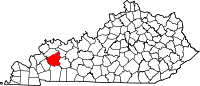
Caldwell County is a county located in the U.S. state of Kentucky. As of the 2020 census, the population was 12,649. Its county seat is Princeton. The county was formed in 1809 from Livingston County, Kentucky and named for John Caldwell, who participated in the George Rogers Clark Indian Campaign of 1786 and was the second lieutenant governor of Kentucky. Caldwell was a prohibition or dry county until 2013, when the citizens voted to lift the ban.

<span class="mw-page-title-main">Parma, Idaho</span> City in Canyon County, Idaho, United States

Parma is a city in Canyon County, Idaho, United States. The population was 1,983 at the 2010 census, up from 1,771 in 2000. It is the fourth largest city in the county and the largest in the rural western portion. It is part of the Boise City–Nampa, Idaho Metropolitan Statistical Area.

<span class="mw-page-title-main">Princeton, Kentucky</span> City in Kentucky, United States

Princeton is a home rule-class city in Caldwell County, Kentucky, in the United States. It is the seat of its county. The population was 6,329 during the 2010 U.S. Census. Princeton is home to several notable attractions such as Adsmore Museum, Champion-Shepherdson House, University of Kentucky Research and Education Center Botanical Garden, Capitol Cinemas, the Annual Black Patch Festival, and Newsom's Aged Kentucky Ham.

<span class="mw-page-title-main">Flemingsburg, Kentucky</span> City in Kentucky, United States

Flemingsburg is a home rule-class city in Fleming County, Kentucky, in the United States. The population was 2,953 at the 2020 census, up from 2,658 at the 2010 census. It is the seat of Fleming County.

<span class="mw-page-title-main">Dry Ridge, Kentucky</span> City in Kentucky, United States

Dry Ridge is a home rule-class city in Grant County, Kentucky, in the United States. The population was 2,191 at the 2010 census, up from 1,995 at the 2000 census. From around 1910 to 1960, the city's economy was dominated by business related to its mineral water wells, purported to have healing properties.

<span class="mw-page-title-main">Madisonville, Kentucky</span> City in Kentucky, United States

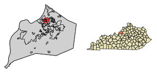
Madisonville is a home rule-class city in and the county seat of Hopkins County, Kentucky, United States, located along Interstate 69 in the state's Western Coal Fields region. The population was 19,591 at the 2010 census. Madisonville is a commercial center of the region and is home to Madisonville Community College.

<span class="mw-page-title-main">Nortonville, Kentucky</span> City in Kentucky, United States

Nortonville is a home rule-class city in Hopkins County, Kentucky, in the United States. The population was 1,204 as of the 2010 census.

<span class="mw-page-title-main">St. Charles, Kentucky</span> City in Kentucky, United States

St. Charles is a home rule-class city in Hopkins County, Kentucky, United States. The population was 277 at the 2010 U.S. Census.

<span class="mw-page-title-main">White Plains, Kentucky</span> City in Kentucky, United States

White Plains is a home rule-class city in Hopkins County, Kentucky, United States. The population was 884 at the 2010 census, up from 800 at the 2000 census.

<span class="mw-page-title-main">Northfield, Kentucky</span> City in Kentucky, United States

Northfield is a home rule-class city in Jefferson County, Kentucky, United States. The population was 1,020 at the 2010 census.

<span class="mw-page-title-main">Spring Mill, Kentucky</span> City in Kentucky, United States

Spring Mill is a home rule-class city in Jefferson County, Kentucky, United States. The population was 287 at the 2010 census, down from 380 at the 2000 census.

<span class="mw-page-title-main">Milton, Kentucky</span> City in Kentucky, United States

Milton is a home rule-class city along the south bank of the Ohio River in Trimble County, Kentucky, United States. The population was 597 at the time of the 2020 census, making it the largest city in Trimble County. The Milton-Madison Bridge connects it to Madison, Indiana, and is the only road link between the two states for 40 miles (64 km) in either direction.

<span class="mw-page-title-main">Springfield, Kentucky</span> City in Kentucky, United States

Springfield is a home rule-class city in and county seat of Washington County, Kentucky, United States. The population was 2,846 at the 2020 census.

<span class="mw-page-title-main">Wessington Springs, South Dakota</span> Town in South Dakota, United States

Wessington Springs is a town in central Jerauld County, South Dakota, United States. The population was 956 at the 2010 census. It is the county seat of Jerauld County.

<span class="mw-page-title-main">Lamesa, Texas</span> City in Texas, United States

Lamesa is a city in and the county seat of Dawson County, Texas, United States. The population was 8,674 at the 2020 census, down from 9,952 at the 2000 census. Located south of Lubbock on the Llano Estacado, Lamesa was founded in 1903. Most of its economy is based on cotton farming. The Preston E. Smith prison unit, named for the former governor of Texas, is located just outside Lamesa.

<span class="mw-page-title-main">Gruver, Texas</span> City in Texas, United States

Gruver is a city in Hansford County, Texas, United States. The population was 1,130 at the 2020 census. Farwell, in the center of Hansford County, approximately three miles east of what became Gruver, was established in 1880 by the Canott family of Illinois, and was the first town in the county. Gruver was established shortly after, and Farwell rapidly fell into oblivion after 1889, when it lost a county seat election to Hansford.

<span class="mw-page-title-main">Chilhowie, Virginia</span> Town in Virginia, United States

Chilhowie is a town in Smyth County, Virginia, United States, on the Middle Fork of the Holston River. The population was 1,781 at the 2010 census. The name Chilhowie is said to come from a Cherokee word meaning "valley of many deer". It is also notable for having only one traffic light in the entire city. I-81 runs through Chilhowie. It is located at exit 35.

References

  1. "Subcounty population estimates: Kentucky 2000-2008" (CSV). United States Census Bureau, Population Division. March 18, 2009. Retrieved April 4, 2009.
  2. "2020 U.S. Gazetteer Files". United States Census Bureau. Retrieved March 18, 2022.
  3. 1 2 "Annual Estimates of the Resident Population for Incorporated Places in Kentucky: April 1, 2020 to July 1, 2022". United States Census Bureau. Retrieved May 26, 2023.
  4. "Summary and Reference Guide to House Bill 331 City Classification Reform" (PDF). Kentucky League of Cities. Retrieved December 30, 2014.
  5. "Profile of Dawson Springs, Kansas in 2020". United States Census Bureau. Archived from the original on December 13, 2021. Retrieved December 13, 2021.
  6. Outwood Veterans Hospital, Dawson Springs, Kentucky, 1922., accessed February 2018.
  7. Settle, Jimmy. "'The whole place was gone': Dawson Springs works to come to grips with tornado's wrath". The Courier-Journal.
  8. 13 dead, more than 100 unaccounted for after tornado rips through Dawson Springs, Ky., accessed December 12th, 2021.
  9. "US Gazetteer files: 2010, 2000, and 1990". United States Census Bureau. February 12, 2011. Retrieved April 23, 2011.
  10. "Geographic Identifiers: 2010 Demographic Profile Data (G001): Dawson Springs city, Kentucky". U.S. Census Bureau, American Factfinder. Archived from the original on February 12, 2020. Retrieved August 5, 2014.
  11. "Dawson Springs, Kentucky Köppen Climate Classification (Weatherbase)". Weatherbase.
  12. "U.S. Census website". United States Census Bureau . Retrieved January 31, 2008.
  13. "Kentucky Public Library Directory". Kentucky Department for Libraries and Archives. Archived from the original on January 11, 2019. Retrieved June 5, 2019.