
Saint Paul is the capital of the U.S. state of Minnesota and the county seat of Ramsey County. Situated on high bluffs overlooking a bend in the Mississippi River, Saint Paul is a regional business hub and the center of Minnesota's government. The Minnesota State Capitol and the state government offices all sit on a hill close to the city's downtown district. One of the oldest cities in Minnesota, Saint Paul has several historic neighborhoods and landmarks, such as the Summit Avenue Neighborhood, the James J. Hill House, and the Cathedral of Saint Paul. Like the adjacent city of Minneapolis, Saint Paul is known for its cold, snowy winters and humid summers.
Union Station, Union Terminal, Union Depot, or Union Passenger Station may refer to:
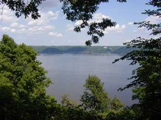
Frontenac State Park is a state park of Minnesota, United States, on the Mississippi River 10 miles (16 km) southeast of Red Wing. The park is notable both for its history and for its birdwatching opportunities. The centerpiece of the park is a 430-foot-high (130 m), 3-mile-long (4.8 km) steep limestone bluff overlooking Lake Pepin, a natural widening of the Mississippi. The bluff is variously called Garrard's Bluff or Point No-Point, the latter name coming from riverboat captains because of the optical illusion that it protruded into the Mississippi River. There is a natural limestone arch on the blufftop called In-Yan-Teopa, a Dakota name meaning "Rock With Opening". Park lands entirely surround the town of Frontenac, once a high-class resort at the end of the 19th century.

The Mississippi National River and Recreation Area is a 72-mile (116 km) and 54,000-acre (22,000 ha) protected corridor along the Mississippi River through the Minneapolis–Saint Paul metro in the U.S. state of Minnesota, from the cities of Dayton and Ramsey, to just downstream of Hastings. This stretch of the upper Mississippi River includes natural, historical, recreational, cultural, scenic, scientific, and economic resources of national significance. This area is the only national park site dedicated exclusively to the Mississippi River. The Mississippi National River and Recreation Area is sometimes abbreviated as MNRRA or MISS, the four letter code assigned to the area by the National Park Service. The Mississippi National River and Recreation Area is classified as one of four national rivers in the United States, and despite its name it is technically not one of the 40 national recreation areas.

The Seventh Street Improvement Arches are a double-arched masonry highway bridge that formerly spanned the St. Paul and Duluth Railroad tracks in Saint Paul, Minnesota, United States. The Seventh Street Improvement Arches are historically significant for its rarity and the technically demanding nature of its skewed, helicoidal spiral, stone-arch design. The bridge is one of the few of its type in the United States, and is the only known bridge of its type in Minnesota. It was built from 1883 to 1884 by Michael O'Brien and McArthur Brothers of Chicago and was designed by William A. Truesdell. The bridge was listed on the National Register of Historic Places in 1989 and on the American Society of Civil Engineers Historic Civil Engineering Landmarks in 2000.
The Lake Superior and Mississippi Railroad is the name of two railroads in Minnesota: a freight and passenger line that operated from 1870 to 1877 and a heritage railroad that has operated since 1981.

Longfellow is a defined community in Minneapolis, Minnesota which includes five smaller neighborhoods inside of it: Seward, Cooper, Hiawatha, Howe and Longfellow. The community is a mix of agri-industrial properties along the old Northern Pacific Railway, expansive parkland surrounding the famous Minnehaha Falls, and smaller residential areas.
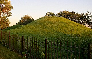
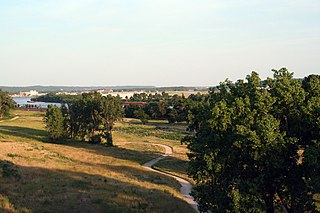
Indian Mounds Regional Park is a public park in Saint Paul, Minnesota, United States, featuring six burial mounds overlooking the Mississippi River. The oldest mounds were constructed beginning about 2,500 years ago by local Indigenous people linked to the Archaic period, who may have been inspired by of the burial style known as the Hopewell Tradition. Mdewakanton Dakota people are also known from historic documents to have interred their dead here well into the historic period. At least 31 mounds were destroyed by development in the late 19th century. This burial mound group includes the tallest mounds constructed by people Indigenous to in Minnesota and Wisconsin. Indian Mounds Regional Park is a component of the Mississippi National River and Recreation Area, a unit of the National Park System. In 2014, the extant Mounds Group was listed in the National Register of Historic Places. The nomination document provides a description of the archaeology and the context. A recent Cultural Landscape Study provides more context regarding the cultural landscape.
The East Side Review was an American, English language newspaper headquartered in St. Paul, Minnesota, until publication ceased in September 2019. While it was published, it was the only neighborhood-focused, general-interest weekly newspaper in either Minneapolis or St. Paul.

Minneapolis is the largest city by population in the U.S. state of Minnesota, and the county seat of Hennepin County. The origin and growth of the city was spurred by the proximity of Fort Snelling, the first major United States military presence in the area, and by its location on Saint Anthony Falls, which provided power for sawmills and flour mills.

Shepard Road and Warner Road are the names given to a four-lane road running along the banks of the Mississippi River in Saint Paul, Minnesota. Shepard Road runs from the southwestern boundary of the county to downtown Saint Paul. From downtown east the road is known as Warner Road (County Road 36; it runs to a junction with US Highways 61 and 10.

Saint Paul, Minnesota, consists of 17 officially defined city districts or neighborhoods.

The Benjamin Brunson House is one of the oldest houses remaining in Saint Paul, Minnesota it was built ca. 1856 in the area known as "railroad island," being surrounded by tracks. It is listed on the National Register of Historic Places.
The Schornstein Grocery and Saloon is a commercial/residential building in Saint Paul, Minnesota, United States. It was built in 1884 for $5,000 in the French Second Empire style, and this Dayton's Bluff business was designed by architect Augustus F. Gauger (1852-1929). It is listed on the National Register of Historic Places.

Saint Paul is the second largest city in the U.S. state of Minnesota, the county seat of Ramsey County, and the state capital of Minnesota. The origin and growth of the city were spurred by the proximity of Fort Snelling, the first major United States military installation in the area, as well as by the city's location on the northernmost navigable port of the Upper Mississippi River.
The Adolf Muench House is listed on the National Register of Historic Places in Saint Paul, Minnesota, United States. The 1884 house designed by Emil W. Ulrici overlooks Saint Paul from the bluffs east of downtown.

The St. Louis County Depot is a historic railroad station in Duluth, Minnesota, United States. It was built as a union station in 1892, serving seven railroads at its peak. Rail service ceased in 1969 and the building was threatened with demolition until it reopened in 1973 as St. Louis County Heritage & Arts Center . Train service also resumed from 1974 to 1985, by Amtrak.
The Bruce Vento Nature Sanctuary is a city park in the Mississippi River corridor in Saint Paul, Minnesota. Just east of the city's downtown district, the sanctuary includes towering limestone and sandstone bluffs that date back more than 450 million years, spring-fed wetlands, abundant bird life, and dramatic views of the downtown Saint Paul skyline and Mississippi River. The park was opened to the public on May 21, 2005, and was named after its early supporter U.S. Representative Bruce Vento.

Selby Avenue is a street in Saint Paul, Minnesota, United States, that runs east–west from Summit Avenue near downtown toward the Mississippi River. The street runs through the Summit-University and Union Park neighborhoods. The street, especially between Dale Street and Snelling Avenue, has been associated with Saint Paul's black community. The far eastern end of the street has historically been more densely developed and architecturally significant.

Mississippi Gorge Regional Park is a regional park along the east and west bluffs of the Mississippi River in the cities of Minneapolis and Saint Paul in the U.S. state of Minnesota. The two-city park area is between Mississippi river miles 848 and 852, from just south of Northern Pacific Bridge Number 9 to just north of Minnehaha Regional Park, and lies within the Mississippi National River and Recreation Area. The park area protects scenic and natural areas of the Mississippi River gorge, the only true gorge along the entire length of the 2,320-mile (3,730 km) river.


