Indian Mounds Park (Saint Paul, Minnesota)

Last updated

Indian Mounds Regional Park
IndianMoundsPark01.jpg
Two Indigenous burial mounds at this park.
USA Minnesota relief location map.svg
Red pog.svg
Location of Indian Mounds Regional Park in Minnesota
Usa edcp relief location map.png
Red pog.svg
Indian Mounds Park (Saint Paul, Minnesota) (the United States)
Location Saint Paul, Minnesota, United States
Coordinates 44°56′44″N93°3′13″W / 44.94556°N 93.05361°W / 44.94556; -93.05361
Area79 acres (32 ha)
Elevation876 ft (267 m) [1]
Established1893 [2]
Governing bodySaint Paul Parks and Recreation
Indian Mounds Park Mound Group
Location1075 Mounds Boulevard, Saint Paul, Minnesota
Coordinates 44°56′45″N93°3′24″W / 44.94583°N 93.05667°W / 44.94583; -93.05667
Area3.6 acres (1.5 ha)
Builtc.1000 BCE–1837
NRHP reference No. 14000140 [3]
Added to NRHPApril 11, 2014

Indian Mounds Regional Park is a public park in Saint Paul, Minnesota, United States, featuring six burial mounds overlooking the Mississippi River. The oldest mounds were constructed about 2,500 years ago by local Indigenous people linked to the Archaic period, who may have been inspired by the burial style known as the Hopewell Tradition. [4] Mdewakanton Dakota people are also known to have interred their dead here well into that period. [2] At least 31 mounds were destroyed by development in the late 19th century. This burial mound group includes the tallest mounds constructed by people Indigenous to Minnesota and Wisconsin (except for the unique 45-foot (14 m) Grand Mound outside International Falls, Minnesota). [5] Indian Mounds Regional Park is a component of the Mississippi National River and Recreation Area, a unit of the National Park System. In 2014, the extant Mounds Group was listed in the National Register of Historic Places. [6] The nomination document describes the archaeology and context. [7] A Cultural Landscape Study provides more context about the cultural landscape.

Contents

Early history

There were once at least 19 mounds at the intact group, plus another 32 a short distance to the northwest directly above Carver's Cave, known as Wakan Tipi (Sacred Home or Tipi) in the Dakota language and considered a sacred place by the Dakota, Ho-Chunk, and Ioway nations. [8] [9] The mounds of the second, Dayton's Bluff Group were all quite small, under two feet (0.6 m) high. [5] In 1957, Eldon Johnson linked archeological information taken from the cemetery in the late 19th century to the burial styles of the Hopewell Burial Tradition, but the closest cultural affiliations are to people indigenous to this area, and there has never been a cultural group of Hopewell people in Minnesota. No evidence of habitation has been found among the mounds. Typically, burial mounds and scaffolds were built on high locations in sight of related nearby villages that were near fresh water. In this case, the historic Dakota village Kaposia, which was near Pig's Eye Lake, is closely linked to the cemetery. [5] The Dakota village of Kaposia was established well before 1600 and in 1766 explorer Jonathan Carver noted that a Dakota leader was buried at this place at that time. [10]

Survey and excavation

Edward Duffield Neill first excavated the mounds in 1856. In 1862, Alfred Hill and William Wallace, members of the Archaeological Committee of the Minnesota Historical Society, documented 21 mound locations at the northwestern "Dayton's Bluff" group and 16 or 17 at the Indian Mounds Park Group. [4] This survey was followed by amateur Antiquarian excavations sponsored in 1886 and 1867 that involved trenching the mounds. [11] The mounds are so large that intrusive excavations often consisted of less than 5% of mound volume. [4] In 1879, Theodore H. Lewis surveyed the mound group again, adding some mound locations. [10] The mound groups had a variety of burial styles. At least three mounds were built around log tombs, and two contained multiple cists made of limestone slabs. [11] Grave goods included mussel shells in the simplest and most common burials, and projectile points, perforated bear teeth, and copper ornaments in others. [11] One burial contained a child's skull with unfired clay pressed onto it, perhaps in an apparent recreation of the child's features. [5] No other such so-called death masks have been documented in local contemporaneous Native American burials. [11] Human remains in funeral bundles found in the upper parts of some mounds have been interpreted as secondary burials from more recent periods. [11]

The early Antiquarian archeologists exhumed around 20 mostly complete skeletons (though many were missing their skulls) and fragments of perhaps another 30, but they did not screen soil and noted that they returned skeletal remains to their backfilled trenches. [5] Excavations only affected small fractions of the mound centers, so the actual number of people buried here is unknown.

These 19th-century archeologists, "some of them amateurs in their day, all of them amateurs by today's standards", [5] may have destroyed as much information as they preserved. Lewis was a sophisticated surveyor for his time, but worked hastily—once excavating seven mounds in a day—and did not describe his finds in detail. [12] Most of the artifacts he collected were sold and have since been lost. But reexamination of stone tools Lewis found in association with the stone cists, which are still held by the Minnesota Historical Society, show that they were made of local materials and date to the Late Archaic period, placing the first burials at this cemetery at least 2,500 years ago, when mound burials were not typically made in this region. [4]

In the late 19th century, the bluff-face was gradually demolished to widen the rail yard at its foot, destroying several mounds as well as the outer chamber of Carver's Cave. [13] In a time "when digging into a mound was a respectable Sunday pastime", [5] locals also repeatedly looted and vandalized the mounds. [8]

The Minnesota Historical Society performed a modern archeological field survey of the mound site in 1981. Christina Harrison conducted excavations under the Air Mail beacon in 1994. Geophysical surveys by Archaeo-Physics in 2012 supported the National Register Nomination. [4]

Park development

Interest in preserving the open land along the blufftop arose in the 1880s as the local population boomed. The City of Saint Paul struggled to buy the land from its various owners, as some were unwilling to sell and others sold to real estate speculators first. By 1896 enough property was assembled for the city to begin landscaping and building visitor amenities. [10] In sharp contrast to modern practices, 11 mounds were leveled because they blocked the view of the river. [12] Only the six largest mounds remained. [8]

The park was expanded to 82 acres (33 ha) in 1900. Later, paths were removed from mounds and soil added to damaged areas, and in 1914 a still-standing brick pavilion was built to house a refreshment stand, restrooms, and space for open-air concerts. [10]

Indian Mounds Regional Park underwent a major restoration in the 1980s using state and federal funds for developing the Great River Road. The pavilion was restored, new amenities added, and houses and a road were removed. The Dayton's Bluff Community Council raised funds and placed decorative fences around the mounds as a protection from visitors. [10]

Airway beacon

The Indian Mounds Park "Airway" Beacon Indian Mounds Park Airway Beacon.jpg
The Indian Mounds Park "Airway" Beacon

Adjacent to the mounds is a 110-foot-high (34 m) airway beacon built in 1929 as part of a national network to aid pilots delivering airmail. [10] The Indian Mounds Park "Airway" Beacon, as it is officially known, helped mark the route between Saint Paul and Chicago. There were once over 600 of these beacons, but electronic navigation systems rendered them obsolete. Restored to its historical black and chrome-yellow color scheme in the mid-1990s, the Indian Mounds Park beacon has been kept operational and flashes its rotating light every five seconds. [14] It is one of the few remaining airway beacons in the U.S. [10] [14]

Recreation

Indian Mounds Regional Park has two electrified picnic shelters that private groups can rent. Other visitor amenities include a playground, barbecue grills, fire rings, restrooms, a drinking fountain, paved trails, a ball field, and tennis courts. [11]

See also

Related Research Articles

<span class="mw-page-title-main">Saint Paul, Minnesota</span> Capital city of Minnesota, United States

Saint Paul is the capital of the U.S. state of Minnesota and the county seat of Ramsey County. Situated on high bluffs overlooking a bend in the Mississippi River, Saint Paul is a regional business hub and the center of Minnesota's government. The Minnesota State Capitol and the state government offices all sit on a hill close to the city's downtown district. One of the oldest cities in Minnesota, Saint Paul has several historic neighborhoods and landmarks, such as the Summit Avenue Neighborhood, the James J. Hill House, and the Cathedral of Saint Paul. Like the adjacent city of Minneapolis, Saint Paul is known for its cold, snowy winters and humid summers.

<span class="mw-page-title-main">Hopewell tradition</span> Ancient North American indigenous civilization

The Hopewell tradition, also called the Hopewell culture and Hopewellian exchange, describes a network of precontact Native American cultures that flourished in settlements along rivers in the northeastern and midwestern Eastern Woodlands from 100 BCE to 500 CE, in the Middle Woodland period. The Hopewell tradition was not a single culture or society but a widely dispersed set of populations connected by a common network of trade routes.

<span class="mw-page-title-main">Serpent Mound</span> Prehistoric effigy mound in Ohio, United States

The Great Serpent Mound is a 1,348-feet-long (411 m), three-feet-high prehistoric effigy mound located in Peebles, Ohio. It was built on what is known as the Serpent Mound crater plateau, running along the Ohio Brush Creek in Adams County, Ohio. The mound is the largest serpent effigy known in the world.

<span class="mw-page-title-main">Wickliffe Mounds</span> Archaeological site in Kentucky, US

Wickliffe Mounds is a prehistoric, Mississippian culture archaeological site located in Ballard County, Kentucky, just outside the town of Wickliffe, about 3 miles (4.8 km) from the confluence of the Ohio and Mississippi rivers. Archaeological investigations have linked the site with others along the Ohio River in Illinois and Kentucky as part of the Angel phase of Mississippian culture. Wickliffe Mounds is controlled by the State Parks Service, which operates a museum at the site for interpretation of the ancient community. Listed on the National Register of Historic Places, it is also a Kentucky Archeological Landmark and State Historic Site.

<span class="mw-page-title-main">Little Crow</span> Chief of Kaposia band of Mdewakantons

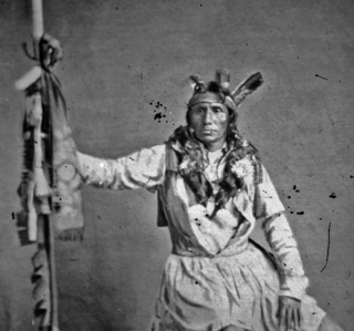
Little Crow III was a Mdewakanton Dakota chief who led a faction of the Dakota in a five-week war against the United States in 1862.

<span class="mw-page-title-main">Frontenac State Park</span> State park in Minnesota, United States

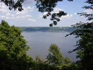
Frontenac State Park is a state park of Minnesota, United States, on the Mississippi River 10 miles (16 km) southeast of Red Wing. The park is notable both for its history and for its birdwatching opportunities. The centerpiece of the park is a 430-foot-high (130 m), 3-mile-long (4.8 km) steep limestone bluff overlooking Lake Pepin, a natural widening of the Mississippi. The bluff is variously called Garrard's Bluff or Point No-Point, the latter name coming from riverboat captains because of the optical illusion that it protruded into the Mississippi River. There is a natural limestone arch on the blufftop called In-Yan-Teopa, a Dakota name meaning "Rock With Opening". Park lands entirely surround the town of Frontenac, once a high-class resort at the end of the 19th century.

<span class="mw-page-title-main">Mississippi National River and Recreation Area</span> National Park Service area in the United States

The Mississippi National River and Recreation Area is a 72-mile (116 km) and 54,000-acre (22,000 ha) protected corridor along the Mississippi River through Minneapolis–Saint Paul in the U.S. state of Minnesota, from the cities of Dayton and Ramsey to just downstream of Hastings. This stretch of the upper Mississippi River includes natural, historical, recreational, cultural, scenic, scientific, and economic resources of national significance. This area is the only national park site dedicated exclusively to the Mississippi River. The Mississippi National River and Recreation Area is sometimes abbreviated as MNRRA or MISS, the four-letter code the National Park Service assigned to the area. The Mississippi National River and Recreation Area is classified as one of four national rivers in the United States, and despite its name is technically not one of the 40 national recreation areas.

<span class="mw-page-title-main">Airway beacon</span> Rotating light assembly mounted atop a tower

An airway beacon (US) or aerial lighthouse was a rotating light assembly mounted atop a tower. These were once used extensively in the United States for visual navigation by airplane pilots along a specified airway corridor. In Europe, they were used to guide aircraft with lighted beacons at night.

<span class="mw-page-title-main">Toolesboro Mound Group</span> United States historic place

The Toolesboro Mound Group, a National Historic Landmark, is a group of Havana Hopewell culture earthworks on the north bank of the Iowa River near its discharge into the Mississippi. The mounds are owned and displayed to the public by the State Historical Society of Iowa. The mound group is located east of Wapello, Iowa, near the unincorporated community of Toolesboro.

<span class="mw-page-title-main">Kaposia</span> Historic Dakota village in St. Paul, Minnesota area

Kaposia or Kapozha was a seasonal and migratory Dakota settlement, also known as "Little Crow's village," once located on the east side of the Mississippi River in present-day Saint Paul, Minnesota. The Kaposia band of Mdewakanton Dakota was established in the late 18th century and led by a succession of chiefs known as Little Crow or "Petit Corbeau." After a flood in 1826, the band moved to the west side of the river, about nine miles below Fort Snelling.

<span class="mw-page-title-main">Sinnissippi Mounds</span> Archaeological site in Illinois, United States

The Sinnissippi Mounds are a Havana Hopewell culture burial mound grouping located in the city of Sterling, Illinois, United States.

<span class="mw-page-title-main">Barn Bluff (Red Wing, Minnesota)</span> United States historic place

Barn Bluff is a bluff along the Mississippi River in Red Wing, Minnesota, United States. The bluff is considered sacred by the Dakota people because it is the site of many burial mounds. During the 19th century, the bluff functioned as a visual reference for explorers and travelers and later served as a limestone quarry.

<span class="mw-page-title-main">Neighborhoods in Saint Paul, Minnesota</span> Communities and neighborhoods in Saint Paul, Minnesota

Saint Paul, Minnesota, consists of 17 officially defined city districts or neighborhoods.

<span class="mw-page-title-main">Dayton's Bluff, Saint Paul</span> Neighborhood in Ramsey, Minnesota, United States

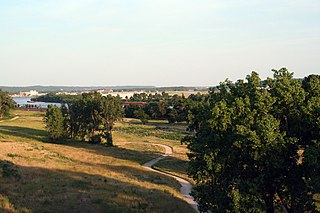
Dayton's Bluff is a neighborhood located on the east side of the Mississippi River in the southeast part of the city of Saint Paul, Minnesota which has a large residential district on the plateau extending backward from its top. The name of the bluff commemorates Lyman Dayton, for whom a city in Hennepin County was also named. On the edge of the southern and highest part of Dayton's Bluff, in Indian Mounds Park, is a series of seven large aboriginal mounds, 4 to 18 feet high, that overlook the river and the central part of the city.

<span class="mw-page-title-main">History of Saint Paul, Minnesota</span>

Saint Paul is the second largest city in the U.S. state of Minnesota, the county seat of Ramsey County, and the state capital of Minnesota. The origin and growth of the city were spurred by the proximity of Fort Snelling, the first major United States military installation in the area, as well as by the city's location on the northernmost navigable port of the Upper Mississippi River.

<span class="mw-page-title-main">Norton Mound group</span> Archaeological site in Michigan, United States

The Norton Mound group,, is a prehistoric Goodall focus mounds site in Wyoming, Michigan that is under the protection of the Grand Rapids Public Museum.

<span class="mw-page-title-main">Bruce Vento Nature Sanctuary</span>

The Bruce Vento Nature Sanctuary is a city park in the Mississippi River corridor in Saint Paul, Minnesota. Just east of the city's downtown district, the sanctuary includes towering limestone and sandstone bluffs that date back more than 450 million years, spring-fed wetlands, abundant bird life, and dramatic views of the downtown Saint Paul skyline and Mississippi River. The park was opened to the public on May 21, 2005, and was named after its early supporter U.S. Representative Bruce Vento.

The Grand Gulf Mound (22CB522) is an Early Marksville culture archaeological site located near Port Gibson in Claiborne County, Mississippi, on a bluff 1 mile (1.6 km) east of the Mississippi River, 2 miles (3.2 km) north of the mouth of the Big Black River. The site has an extant burial mound, and may have possibly had two others in the past. The site is believed to have been occupied from 50 to 200 CE. Copper objects, Marksville culture ceramics and a stone platform pipe were found in excavations at the site. The site is believed to be the only site in the Natchez Bluffs region to have been actively involved in the Hopewell Interaction Sphere. It is one of four mounds in the area believed to date to the Early Marksville period, the other three being the Marskville Mound 4 and Crooks Mounds A and B, all located in nearby Louisiana. The mound itself was built in several stages over many years, very similar to the Crooks Mound A in La Salle Parish, Louisiana. Unlike some other Hopewell sites, such as the Tremper Mound in Scioto County, Ohio, the site showed no evidence of a mortuary or communal structure previous to the construction of the mound. The beginning stage is believed to have been a rectangular earthen platform .5 feet (0.15 m) in height, 20 feet (6.1 m) wide on its east–west axis and 3.5 feet (1.1 m) long on its north–south axis. After a period of use, this platform was covered with a mantle of earth 5.5 feet (1.7 m) in height and 26.5 feet (8.1 m) wide along its east–west axis, with an extremely hard cap of earth 0.2 feet (0.061 m) covering the mound. During a third stage another mantle of earth was added to the mound, bringing it to a height of 10 feet (3.0 m) and to approximately 32 feet (9.8 m) in width on its east–west axis.

<span class="mw-page-title-main">Bdóte</span> Location in Minnesota considered the center of the universe in Dakota tradition

Bdóte is a significant Dakota sacred landscape where the Minnesota and Mississippi Rivers meet, encompassing Pike Island, Fort Snelling, Coldwater Spring, Indian Mounds Park, and surrounding areas in present-day Minneapolis and Saint Paul, Minnesota, United States. In Dakota geographic memory, it is a single contiguous area not delineated by any contemporary areas' borders. According to Dakota oral tradition, it is the site of creation; the interconnectedness between the rivers, earth, and sky are important to the Dakota worldview and the site maintains its significance to the Dakota people.

References

  1. "Indian Mounds Park". Geographic Names Information System . United States Geological Survey. January 11, 1980. Retrieved April 21, 2011.
  2. 1 2 "Indian Mounds Park". Mississippi National River and Recreation Area: Plan Your Visit. National Park Service. January 16, 2009. Retrieved April 21, 2001.
  3. "Indian Mounds Park Mound Group". www.nps.gov. Archived from the original on April 21, 2021. Retrieved April 19, 2022.
  4. 1 2 3 4 5 Arnott, Sigrid; Jones, Geoff; Maki, David (2014). National Register of Historic Places Nomination Form, Indian Mounds Park Mound Group. Washington, DC: National Park Service.
  5. 1 2 3 4 5 6 7 Nelson, Paul D. (May 20, 2008). "St. Paul's Indian Burial Mounds". Staff Publications. No. 1. Retrieved April 21, 2001.
  6. Anderson, Jim (July 13, 2014). "St. Paul mounds find their ground on National Register of Historic Places". Minneapolis Star-Tribune . Retrieved July 13, 2014.
  7. "Indian Mounds Park Mound Group"
  8. 1 2 3 "The Indian Mounds Park Site". From Site to Story: The Upper Mississippi's Buried Past. The Institute for Minnesota Archaeology. June 29, 1999. Retrieved April 21, 2011.
  9. "Indian Mounds - A Sacred Place of Burial". Where We Work: Indian Mounds. Wakan Tipi Awanyankapi. Retrieved April 14, 2023.
  10. 1 2 3 4 5 6 7 Trimble, Steve (July 2, 2000). "A Short History of Indian Mounds Park". Dayton's Bluff District Four Community Council. Archived from the original on May 1, 2011. Retrieved April 21, 2011.
  11. 1 2 3 4 5 6 Woitas, Kay. "Indian Mounds Park (Regional)". City of St. Paul. Retrieved April 21, 2011.
  12. 1 2 Garvey, Dennis W. "Indian Mounds Park and Dayton's Bluff Mound Groups". Ancestry.com. Retrieved April 1, 2019.
  13. "Lower Phalen Creek". Archived from the original on April 29, 2005. Retrieved September 9, 2006.
  14. 1 2 Cosimini, Greg (July 9, 1999). "Indian Mounds Park "Airway" Beacon". University of Minnesota. Archived from the original on January 24, 2008. Retrieved April 21, 2011.