
The Hopewell tradition describes the common aspects of Native American culture that flourished in settlements along rivers in the northeastern and midwestern Eastern Woodlands from 100 BCE to 500 CE, in the Middle Woodland period. The Hopewell tradition was not a single culture or society, but a widely dispersed set of populations connected by a common network of trade routes. This is known as the Hopewell exchange system.

Clear Lake Site is an archaeological site located in Sand Ridge State Park 6.5 miles (10.5 km) from Manito, Illinois. The site was occupied for the majority of the period from 500 B.C. to 1500 A.D.; cultures which have occupied the site include the Early Woodland, Havana Hopewell, and Mississippian. The site consists of a village area and two burial mounds. University of Chicago archaeologists conducted the first excavations at the site in 1932. Significant further excavations were conducted by George and Ethel Schoenbeck of the Peoria Academy of Science; the couple recovered 24,000 pottery shards from the site which represent every pottery type found in Central Illinois. The Illinois State Museum, which received all artifacts recovered by the Schoenbecks, conducted its own excavations at the site in the 1950s.

The Trowbridge Archaeological Site is located in the vicinity of North 61st Street and Leavenworth Road in Kansas City, Kansas. Discovered in 1939 by amateur archaeologist Harry Trowbridge in the back yard of his property, it was inhabited c. AD 200–600 by the Kansas City Hopewell culture.

The Shawnee Lookout Archeological District is a historic district in the southwestern corner of the U.S. state of Ohio. Located southwest of Cleves in Hamilton County's Miami Township, the district is composed of forty-six archaeological sites spread out over an area of 2,000 acres (810 ha). Thirty-four of these sites are located in the 1,000-acre (400 ha) Shawnee Lookout Park, which has been called one of the most beautiful parks in southwestern Ohio.

The Kincaid Mounds Historic Site c. 1050–1400 CE, is a Mississippian culture archaeological site located at the southern tip of present-day U.S. state of Illinois, along the Ohio River. Kincaid Mounds has been notable for both its significant role in native North American prehistory and for the central role the site has played in the development of modern archaeological techniques. The site had at least 11 substructure platform mounds, and 8 other monuments.

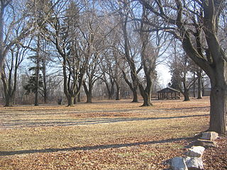
Albany Mounds State Historic Site, also known as Albany Mounds Site, is a historic site operated by the Illinois Historic Preservation Agency. It spans over 205 acres of land near the Mississippi river at the northwest edge of the state of Illinois in the United States. In 1974, the site was added to the National Register of Historic Places list. The historical site is under the provision of the Illinois Historic Preservation Agency, a governmental agency founded in 1985 for the maintaining of historical sites within the state. In the 1990s, the site underwent a restoration project that aimed to return its appearance to its original condition.
The Portsmouth Earthworks are a large prehistoric mound complex constructed by the Ohio Hopewell culture mound builder indigenous peoples of eastern North America. The site was one of the largest earthwork ceremonial centers constructed by the Hopewell and is located at the confluence of the Scioto and Ohio Rivers, in present-day Ohio.

Prehistory of Ohio provides an overview of the activities that occurred prior to Ohio's recorded history. The ancient hunters, Paleo-Indians, descended from humans that crossed the Bering Strait. There is evidence of Paleo-Indians in Ohio, who were hunter-gatherers that ranged widely over land to hunt large game. For instance, mastodon bones were found at the Burning Tree Mastodon site that showed that it had been butchered. Clovis points have been found that indicate interaction with other groups and hunted large game. The Paleo Crossing Site and Nobles Pond Site provide evidence that groups interacted with one another. The Paleo-Indian's diet included fish, small game, and nuts and berries that gathered. They lived in simple shelters made of wood and bark or hides. Canoes were created by digging out trees with granite axes.

The Goodall Focus was a Hopewellian culture from the Middle Woodland period peoples that occupied Western Michigan and northern Indiana from around 200 BCE to 500 CE. Extensive trade networks existed at this time, particularly among the many local cultural expressions of the Hopewell communities. The Goodall pattern stretched from the southern tip of Lake Michigan, east across northern Indiana, to the Ohio border, then northward, covering central Michigan, almost reaching to Saginaw Bay on the east and Grand Traverse Bay to the north. The culture is named for the Goodall Site in northwest Indiana.

The Laurel Complex was a Native American culture in southern Quebec, southern and northwestern Ontario and east-central Manitoba in Canada and northern Michigan, northwestern Wisconsin and northern Minnesota in the United States. They were the first pottery using people of Ontario north of the Trent-Severn Waterway. The complex is named after the former unincorporated community of Laurel, Minnesota.

The Renner Village Archeological Site (23PL1) is a prehistoric archaeological site located in the municipality of Riverside, Platte County, Missouri. It was a village site inhabited from approximately 1 CE to 500 CE by peoples of the Kansas City Hopewell culture and through the Woodland period to 1200 CE by peoples of the Middle Mississippian culture. It was added to the National Historic Register on April 16, 1969.
The Memorial Park Site is an archaeological site located near the confluence of Bald Eagle Creek and the West Branch Susquehanna River in Lock Haven in the U.S. state of Pennsylvania. Research projects conducted at the site since 1979 have found prehistoric cultural deposits that collectively span 8,000 years.
The Mann Site is a Crab Orchard culture site located off Indian Mound Road in Mount Vernon, Posey County, Indiana. It was placed on the National Historic Register on October 1, 1974. Exotic ceramics and other artifacts found at the site reflect contact with Ohio Hopewell and Swift Creek culture people of the Georgia Piedmont and Gulf Coastal Plain.
The Ufferman Site is an archaeological site in the central part of the U.S. state of Ohio. Located north of the city of Delaware, it occupies approximately 2 acres (0.81 ha) of land near Delaware Lake on property near to the boundaries of Delaware State Park. It appears to have been the location of a village of the Cole culture, which inhabited the region during the later portion of the Woodland period. Ufferman lies only 0.6 kilometres (0.37 mi) south of the W.S. Cole Site, the type site for the culture, and approximately 23 kilometres (14 mi) north of the Highbank Park Works, which are believed to have been built by peoples of the Cole culture.

The LoDaisKa Site is a prominent archaeological site in the U.S. state of Colorado, located within a rockshelter near Morrison. The rockshelter was first inhabited by people of the Archaic through the Middle Ceramic period, generally spanning 3000 BC to 1000 AD.
The Beam Farm Woodland Archaeological District is a group of archaeological sites in the southwestern part of the U.S. state of Ohio. Located at 3983 Stone Road near the village of Sabina in Clinton County, the district is composed of one Native American mound and two other archaeological sites spread out over an area of 2 acres (0.81 ha). Known as the Beam Farm Mound and the Beam Sites 9 and 12, the sites that compose the district have yielded artifacts from the Adena culture and the Hopewell tradition, both of which inhabited southwestern Ohio during the Woodland period. Because both the Adena and the Hopewell lived around the mound, and because both cultures built mounds, the identity of the people who constructed the Beam Farm Mound cannot be established; all that can be known with reasonable certainty is that it was raised during the early or middle portion of the Woodland period, or between 800 BC and AD 500.

The Cleiman Mound and Village Site is a prehistoric archaeological site located near the Mississippi River in Jackson County, Illinois. The site includes an intact burial mound and the remains of a village site. The village was inhabited by a number of prehistoric cultures during the Archaic, Woodland, and Mississippian periods; settlement at the site began prior to 400 B.C. and lasted through 1300 A.D. The mound was built during the Middle Woodland Period by Hopewellian peoples and is likely the only Hopewell mound in the Mississippi Valley in Southern Illinois.

The Golden Eagle-Toppmeyer Site is a pre-Columbian archaeological site located near the confluence of the Illinois and Mississippi Rivers in Calhoun County, Illinois. The site is associated with the Havana Hopewell culture and has two main components: the Golden Eagle earthwork and the Toppmeyer habitation site. The earthwork, which dates from the Middle Woodland period, is the only geometric earthwork from the period in the central Mississippi River valley. Two mounds are incorporated in the rounded earthwork; one is located at the center, and one is located at a gap which has been called the "entrance" to the earthwork. The Toppmeyer habitation site, which overlaps the western edge of the earthwork, dates from the Late Woodland period. The overall site was likely a regional transaction center at which extensive trade and cultural exchange among Hopewell people in the Illinois River valley took place.

The Glenwood Archeological District is a nationally recognized historic district and archaeological sites located in the vicinity of Glenwood, Iowa, United States. It is one of nine sites from the Nebraska Phase of the Woodland period recognized by archaeologists, and the only one located east of the Missouri River. The district is made up of earth lodge sites, mortuary sites and artifact scatters from the Glenwood culture. They date from sometime between 1250 and 1400 C.E.. The district was listed on the National Register of Historic Places in 2013.


