Saline County, Illinois

Last updated

Saline County
Harrisburg, IL 1917 Saline County Courthouse.jpg
Former Saline County Courthouse in Harrisburg
Seal of Saline County, Illinois.svg
Map of Illinois highlighting Saline County.svg
Location within the U.S. state of Illinois
Illinois in United States.svg
Illinois's location within the U.S.
Coordinates: 37°45′N88°32′W / 37.75°N 88.54°W / 37.75; -88.54
CountryFlag of the United States.svg United States
StateFlag of Illinois.svg  Illinois
Founded1847
Named for Saline River
Seat Harrisburg
Largest cityHarrisburg
Area
  Total387 sq mi (1,000 km2)
  Land380 sq mi (1,000 km2)
  Water7.0 sq mi (18 km2)  1.8%
Population
 (2020)
  Total23,768
  Density61/sq mi (24/km2)
Time zone UTC−6 (Central)
  Summer (DST) UTC−5 (CDT)
Congressional district 12th
Website www.salinecounty.illinois.gov

Saline County is a county in Southern Illinois. At the 2020 census, it had a population of 23,768. [1] The largest city and county seat is Harrisburg. [2] This area of Southern Illinois is known locally as "Little Egypt".

Contents

Three major towns in Saline County are connected by U.S. Route 45, and formerly by the now-abandoned Cairo and Vincennes/Big Four/New York Central Line, from north to south: Eldorado, Harrisburg, and Carrier Mills.

Geography

According to the U.S. Census Bureau, the county has a total area of 387 square miles (1,000 km2), of which 380 square miles (980 km2) is land and 7.0 square miles (18 km2) (1.8%) is water. [3]

The Saline County area is mostly rolling hills throughout gradually rising to the Hills of the Shawnee National Forest. The Saline River flows through the central point of the county in three forks: North, Middle, and South. To the north of Eldorado there are flat lowlands. [4]

Climate and weather

Harrisburg, Illinois
Climate chart (explanation)
J
F
M
A
M
J
J
A
S
O
N
D
 
 
3.2
 
 
40
22
 
 
3.1
 
 
46
25
 
 
4.4
 
 
57
35
 
 
4.6
 
 
68
45
 
 
5
 
 
77
54
 
 
4.5
 
 
85
63
 
 
3.9
 
 
89
68
 
 
3.2
 
 
88
65
 
 
3
 
 
81
57
 
 
3
 
 
70
44
 
 
4.2
 
 
56
36
 
 
3.9
 
 
45
26
Average max. and min. temperatures in °F
Precipitation totals in inches
Source: The Weather Channel [5]
Metric conversion
J
F
M
A
M
J
J
A
S
O
N
D
 
 
81
 
 
4
−6
 
 
78
 
 
8
−4
 
 
113
 
 
14
2
 
 
118
 
 
20
7
 
 
126
 
 
25
12
 
 
114
 
 
29
17
 
 
100
 
 
32
20
 
 
82
 
 
31
18
 
 
77
 
 
27
14
 
 
77
 
 
21
7
 
 
107
 
 
13
2
 
 
99
 
 
7
−3
Average max. and min. temperatures in °C
Precipitation totals in mm

In recent years, average temperatures in the county seat of Harrisburg have ranged from a low of 22 °F (−6 °C) in January to a high of 89 °F (32 °C) in July, although a record low of −23 °F (−31 °C) was recorded in February 1951 and a record high of 113 °F (45 °C) was recorded in July 1936. Average monthly precipitation ranged from 3.04 inches (77 mm) in September to 4.98 inches (126 mm) in May. [5]

Adjacent counties

National protected area

State protected areas

Transportation

Transit

Major highways

Demographics

Historical population
CensusPop.Note
1850 5,588
1860 9,33167.0%
1870 12,71436.3%
1880 15,94025.4%
1890 19,34221.3%
1900 21,68512.1%
1910 30,20439.3%
1920 38,35327.0%
1930 37,100−3.3%
1940 38,0662.6%
1950 33,420−12.2%
1960 26,227−21.5%
1970 25,721−1.9%
1980 28,44810.6%
1990 26,551−6.7%
2000 26,7330.7%
2010 24,913−6.8%
2020 23,768−4.6%
2023 (est.)22,873 [6] −3.8%
U.S. Decennial Census [7]
1790-1960 [8] 1900-1990 [9]
1990-2000 [10] 2010-2013 [1]

As of the 2010 United States Census, there were 24,913 people, 10,379 households, and 6,631 families residing in the county. [11] The population density was 65.6 inhabitants per square mile (25.3/km2). There were 11,697 housing units at an average density of 30.8 per square mile (11.9/km2). [3] The racial makeup of the county was 93.0% white, 4.0% black or African American, 0.4% Asian, 0.4% American Indian, 0.1% Pacific islander, 0.4% from other races, and 1.8% from two or more races. Those of Hispanic or Latino origin made up 1.4% of the population. [11] In terms of ancestry, 17.8% were Irish, 16.6% were German, 12.9% were American, and 11.1% were English. [12]

Of the 10,379 households, 29.0% had children under the age of 18 living with them, 47.4% were married couples living together, 11.7% had a female householder with no husband present, 36.1% were non-families, and 31.9% of all households were made up of individuals. The average household size was 2.32 and the average family size was 2.89. The median age was 41.7 years. [11]

The median income for a household in the county was $35,644 and the median income for a family was $46,314. Males had a median income of $41,108 versus $28,464 for females. The per capita income for the county was $20,903. About 13.4% of families and 18.4% of the population were below the poverty line, including 26.5% of those under age 18 and 10.4% of those age 65 or over. [13]

Communities

Cities

Villages

Unincorporated communities

Townships

Saline County is divided into thirteen townships:

Politics

United States presidential election results for Saline County, Illinois [14]
Year Republican Democratic Third party
No.%No.%No.%
2020 8,10373.07%2,78925.15%1971.78%
2016 8,27672.70%2,57222.59%5364.71%
2012 6,80663.49%3,70134.52%2131.99%
2008 6,09953.15%5,08344.29%2942.56%
2004 7,05759.73%4,69739.76%600.51%
2000 5,93350.93%5,42746.58%2902.49%
1996 3,69331.66%6,15652.77%1,81615.57%
1992 3,66727.67%7,25854.76%2,32917.57%
1988 5,79846.31%6,67653.32%470.38%
1984 7,17654.15%6,03845.57%370.28%
1980 7,15753.95%5,68342.84%4253.20%
1976 5,97044.25%7,47255.38%510.38%
1972 7,66059.30%5,22640.46%320.25%
1968 6,91349.92%5,98543.22%9516.87%
1964 5,69140.57%8,33759.43%00.00%
1960 8,85356.36%6,83543.52%190.12%
1956 8,48153.96%7,21545.91%200.13%
1952 9,20654.13%7,77145.70%290.17%
1948 7,67649.57%7,71849.84%910.59%
1944 9,08354.92%7,35144.45%1050.63%
1940 10,56749.43%10,69250.02%1180.55%
1936 9,05546.16%10,25352.27%3081.57%
1932 6,29438.21%9,72559.04%4542.76%
1928 7,52553.82%6,33745.32%1210.87%
1924 6,08447.03%4,03731.21%2,81621.77%
1920 6,72252.96%3,50027.58%2,47019.46%
1916 7,06150.49%5,93042.41%9937.10%
1912 1,46818.10%3,59944.37%3,04437.53%
1908 3,12552.12%2,47141.21%4006.67%
1904 2,73556.93%1,75836.59%3116.47%
1900 2,49552.46%2,18645.96%751.58%
1896 2,60552.81%2,29646.54%320.65%
1892 2,17149.90%1,82842.01%3528.09%

See also

Related Research Articles

<span class="mw-page-title-main">Putnam County, Illinois</span> County in Illinois, United States

Putnam County is the least extensive county in the U.S. state of Illinois. According to the 2020 census, it had a population of 5,637. The county seat is Hennepin. The county was formed in 1825 out of Fulton County and named after Israel Putnam, who was a general in the American Revolution. Putnam County is part of the Ottawa, IL Micropolitan Statistical Area.

<span class="mw-page-title-main">Williamson County, Illinois</span> County in Illinois, United States

Williamson County is a county in Southern Illinois. At the 2020 census, it had a population of 67,153. The largest city and county seat is Marion.

<span class="mw-page-title-main">Shelby County, Illinois</span> County in Illinois, United States

Shelby County is a county located in the U.S. state of Illinois. According to the 2020 census, it had a population of 20,990. Its county seat is Shelbyville.

<span class="mw-page-title-main">Scott County, Illinois</span> County in Illinois, United States

Scott County is a county located in the U.S. state of Illinois. According to the 2020 census, it had a population of 4,949, making it the fourth-least populous county in Illinois. Its county seat is Winchester.

<span class="mw-page-title-main">McDonough County, Illinois</span> County in Illinois, United States

McDonough County is a county in the U.S. state of Illinois. According to the 2020 census, it had a population of 27,238. Its county seat is Macomb, which is also the home of Western Illinois University.

<span class="mw-page-title-main">Johnson County, Illinois</span> County in Illinois, United States

Johnson County is a county in the U.S. state of Illinois. According to the 2020 census, it has a population of 13,308. Its county seat is Vienna. It is located in the southern portion of Illinois known locally as "Little Egypt".

<span class="mw-page-title-main">Hamilton County, Illinois</span> County in Illinois, United States

Hamilton County is a county located in the U.S. state of Illinois. At the 2020 census, its population was 7,993. Its county seat is McLeansboro. It is located in the southern portion of the state known locally as "Little Egypt".

<span class="mw-page-title-main">Gallatin County, Illinois</span> County in Illinois, United States

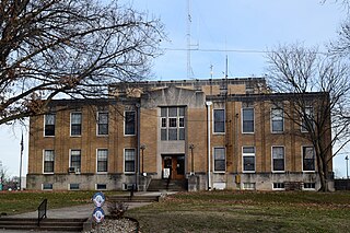
Gallatin County is a county located in the U.S. state of Illinois. According to the 2020 census, it has a population of 4,946, making it the third-least populous county in Illinois. Its county seat is Shawneetown. It is located in the southern portion of Illinois known locally as Little Egypt. Located at the mouth of the Wabash River, Gallatin County, along with neighboring Posey County, Indiana, and Union County, Kentucky form the tri-point of the Illinois-Indiana-Kentucky Tri-State Area.

<span class="mw-page-title-main">Thompsonville, Illinois</span> Village in Illinois, United States

Thompsonville is a village in Cave Township, Franklin County, Illinois, United States. The population was 486 at the 2020 census.

<span class="mw-page-title-main">Equality, Illinois</span> Village in Illinois, United States

Equality is a village in Gallatin County, Illinois, United States. The population was 539 at the 2020 census. Near the village are two points of interest, the Crenshaw House and the Garden of the Gods Wilderness. Equality was the county seat of Gallatin County from 1826–1851.

<span class="mw-page-title-main">Ridgway, Illinois</span> Village in Illinois, United States

Ridgway is a village in Gallatin County, Illinois, United States. As of the 2020 census, the population was 851. As of 2018, Rebecca Mitchell was the town mayor.

<span class="mw-page-title-main">Broughton, Illinois</span> Village in Illinois, United States

Broughton is a village in Hamilton County, Illinois, United States. The population was 194 at the 2010 census. It is part of the Mount Vernon Micropolitan Statistical Area.

<span class="mw-page-title-main">New Burnside, Illinois</span> Village in Illinois, United States

New Burnside is a village in Johnson County, Illinois, United States. The population was 211 at the 2010 census.

<span class="mw-page-title-main">Eldorado, Illinois</span> City in Illinois, United States

Eldorado is a city in Saline County, Illinois, United States. The population was 4,122 at the 2010 census, with a 1980 peak of 5,198. Although the city's name is spelled as if it were Spanish, the name was originally "Eldereado" or “Elder-Reado” —a combination of the last names of the town's two founders, Judge Samuel Elder, his son William, grandson Francis Marion, and neighbor Joseph Read, and his brother William. According to legend, a signpainter for the railroad painted the name "Eldorado" on the train depot; as a result, the spelling and pronunciation (el-do-RAY-doh) was forever changed.

<span class="mw-page-title-main">Galatia, Illinois</span> Village in Illinois, United States

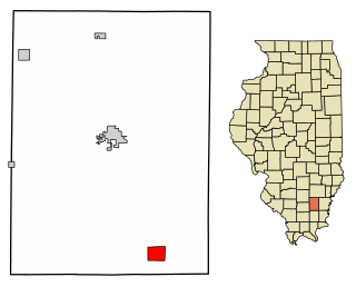
Galatia is a village in Saline County, Illinois, in the United States. As of the 2010 census, the village population was 933.

<span class="mw-page-title-main">Muddy, Illinois</span> Village in Illinois, United States

Muddy is a small incorporated village located in the Harrisburg Township in Saline County, Illinois, United States. The population was 78 at the 2000 census.

<span class="mw-page-title-main">Raleigh, Illinois</span> Village in Illinois, United States

Raleigh is a village in Saline County, Illinois, United States. The population was 330 at the 2000 census.

<span class="mw-page-title-main">Stonefort, Illinois</span> Village in Illinois, United States

Stonefort is a village in Saline and Williamson Counties, Illinois, United States. The population was 297 at the 2010 census.

<span class="mw-page-title-main">Galatia, Kansas</span> City in Barton County, Kansas

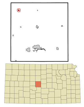
Galatia is a city in Barton County, Kansas, United States. As of the 2020 census, the population of the city was 45.

Harrisburg is a rural small town in Lewis County, New York, United States. The population was 437 at the 2010 census. The town is in the northwestern part of the county, northwest of Lowville, the county seat.

References

  1. 1 2 "State & County QuickFacts". United States Census Bureau. Archived from the original on June 7, 2011. Retrieved July 8, 2014.
  2. "Find a County". National Association of Counties. Retrieved June 7, 2011.
  3. 1 2 "Population, Housing Units, Area, and Density: 2010 - County". United States Census Bureau. Archived from the original on February 12, 2020. Retrieved July 12, 2015.
  4. State Geologist, Illinois (1875). "Geological Survey of Illinois". google.com. Retrieved June 14, 2015.
  5. 1 2 "Monthly Averages for Harrisburg, Illinois". The Weather Channel. Retrieved January 27, 2011.
  6. "Annual Estimates of the Resident Population for Counties: April 1, 2020 to July 1, 2023". United States Census Bureau. Retrieved April 2, 2024.
  7. "U.S. Decennial Census". United States Census Bureau. Retrieved July 8, 2014.
  8. "Historical Census Browser". University of Virginia Library. Retrieved July 8, 2014.
  9. "Population of Counties by Decennial Census: 1900 to 1990". United States Census Bureau. Retrieved July 8, 2014.
  10. "Census 2000 PHC-T-4. Ranking Tables for Counties: 1990 and 2000" (PDF). United States Census Bureau. Retrieved July 8, 2014.
  11. 1 2 3 "DP-1 Profile of General Population and Housing Characteristics: 2010 Demographic Profile Data". United States Census Bureau. Archived from the original on February 13, 2020. Retrieved July 12, 2015.
  12. "DP02 SELECTED SOCIAL CHARACTERISTICS IN THE UNITED STATES – 2006-2010 American Community Survey 5-Year Estimates". United States Census Bureau. Archived from the original on February 13, 2020. Retrieved July 12, 2015.
  13. "DP03 SELECTED ECONOMIC CHARACTERISTICS – 2006-2010 American Community Survey 5-Year Estimates". United States Census Bureau. Archived from the original on February 13, 2020. Retrieved July 12, 2015.
  14. Leip, David. "Dave Leip's Atlas of U.S. Presidential Elections". uselectionatlas.org.

37°45′N88°32′W / 37.75°N 88.54°W / 37.75; -88.54