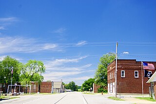
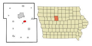
West Frankfort is a city in Franklin County, Illinois. The population was 7,275 at the 2020 census.[3] The city is well known for its rich history of coal. The city is part of the Metro Lakeland area.
Although one might associate the name "West Frankfort" with the city "Frankfurt" in Germany, or Frankfort in Kentucky, the truth is far more local. Around 1810, early Tennessee settler Francis ("Frank") Jordan and his seven brothers began the construction of a fort atop a hill in present-day Franklin County. Completed in 1811, the fort was named "Frank's Fort," in Jordan's honor.[4]
Frank's Fort was built in today's Williamson County, Ill., near Corinth. A few miles to the east, Francis' brother, Thomas Jordan, built "Jordan's Fort" in Cave Township, Franklin County, Ill., near the town of Thompsonville.
The construction of these forts was in response to the danger of attack during Tecumseh's War, which culminated in the Battle of Tippecanoe in 1811. Then-governor of the Illinois Territory, Ninian Edwards, actively encouraged the construction of these forts and offered the services of the Saline Militia in their erection.[4] Thus, both Jordan family forts were built with the help of the Illinois Militia for safety of the civilians.
Since the Shawnee Trail, an important trading route linking Kaskaskia, Illinois and Old Shawneetown, Illinois, ran along the high ground in the vicinity of the fort, this area became an attractive destination for settlers in search of cheap land made available by the recently passed Bit Act of 1850. The resulting settlement took the name of the nearby fort, which was subsequently shortened to "Frankfort." Frankfort grew quickly during this period, with its population rivaling that of Chicago, at the time.[4]
Frankfort was Franklin County's first county seat until 1839, when the lower half of the county was declared as Williamson County.
After railroad tracks linking Chicago, Paducah, and Memphis, were laid 4 miles (6km) west of Frankfort, many businesses and residents migrated to the new commercial center forming near the tracks. This new community became known as West Frankfort, for its location to the west of Frankfort. The two cities eventually merged and retained the name West Frankfort.[4]
The area of West Frankfort formerly known as Frankfort is still sometimes referred to locally as Frankfort Heights or, more commonly, simply as "The Heights", due to its higher elevation relative to the rest of the city. A post office was maintained in Frankfort Heights until its destruction by fire in 2004, making West Frankfort one of the smallest cities in the United States to have two ZIP codes (the other zip code is designated as "Frankfort Heights, Illinois").[4]
Beginning in 1904, the Deering Coal Mine Company took Franklin County and West Frankfort from no coal production in 1900 to being the #1 coal producer in Illinois by 1917. Once the mines opened, the population increased 3,500 in seven years. By 1927, West Frankfort's population had reached 19,896. In the late 1940s, four theatres and a minor league baseball team (see below) marked the downtown area.
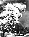
The Orient No. 2 coal mine exploded on December 21, 1951, killing 119 men.[7] The mine, located outside of West Frankfort, was one of the area's major employers. According to lifelong residents, everyone in West Frankfort was affected by this tragedy, including grade schoolers of the time who remember their own losses or the suffering of classmates. Many residents had even said they could never celebrate Christmas again. After the catastrophe, the West Frankfort Junior High School became a temporary morgue for identification of the bodies,[8] with many calls going out for funeral directors. The explosion received national attention from the wire services, newspapers and Life Magazine.[citation needed] Illinois Governor Adlai Stevenson visited the site to support those mourning.[citation needed] The United States Bureau of Mines called the explosion "avoidable," with the disaster resulting in Congress passing the Federal Coal Mine Safety Act of 1952.[citation needed] In 2020, after years of planning and funding, locals unveiled a new $40,000 (~$46,398 in 2023) memorial monument in Coal Miners Memorial Park, which reads the names of all 119 men killed in the disaster.[citation needed]
Eclipse crossroads of America
The area was in totality during the solar eclipse of August 21, 2017, with Giant City State Park, approximately 25 miles (40km) to the southwest, experiencing the longest period of totality during the eclipse (approximately 2 minutes and 40 seconds).[9] It will also be within the path of totality of the solar eclipse of April 8, 2024, making it one of only a handful of cities within the direct paths of both eclipses.
According to the 2021 census gazetteer files, West Frankfort has a total area of 5.02 square miles (13.00km2), of which 4.98 square miles (12.90km2) (or 99.26%) is land and 0.04 square miles (0.10km2) (or 0.74%) is water.[11]
As of the 2020 census[3] there were 7,275 people, 3,204 households, and 1,950 families residing in the city. The population density was 1,450.07 inhabitants per square mile (559.88/km2). There were 3,766 housing units at an average density of 750.65 per square mile (289.83/km2). The racial makeup of the city was 92.60% White, 0.67% African American, 0.38% Native American, 0.52% Asian, 0.04% Pacific Islander, 0.47% from other races, and 5.31% from two or more races. Hispanic or Latino of any race were 2.12% of the population.
There were 3,204 households, out of which 30.0% had children under the age of 18 living with them, 35.08% were married couples living together, 20.44% had a female householder with no husband present, and 39.14% were non-families. 35.33% of all households were made up of individuals, and 20.91% had someone living alone who was 65 years of age or older. The average household size was 2.94 and the average family size was 2.33.
The city's age distribution consisted of 22.3% under the age of 18, 9.1% from 18 to 24, 22.7% from 25 to 44, 26.3% from 45 to 64, and 19.6% who were 65 years of age or older. The median age was 41.9 years. For every 100 females, there were 95.8 males. For every 100 females age 18 and over, there were 91.0 males.
The median income for a household in the city was $30,938, and the median income for a family was $32,018. Males had a median income of $36,964 versus $19,228 for females. The per capita income for the city was $18,268. About 30.2% of families and 32.6% of the population were below the poverty line, including 48.1% of those under age 18 and 17.3% of those age 65 or over.
Each year West Frankfort hosts the Old King Coal Festival. This four-day event is held every May. Now coinciding with Rend Lake Festival, held in nearby Benton. Formerly the Old King Coal Festival was held in the third week of September; to pay tribute to coal miners with a parade, concerts, pageants, carnival rides and a wide variety of food.
West Frankfort is also home to Candy Cane Lane, a large lights display featured every year around Christmas. The display involves several blocks of homes, including a large display by a local art teacher. In 2019, areas of Candy Cane Lane were featured on the ABC show The Great Christmas Light Fight.[15][16]
West Frankfort is home to the Frankfort Area Historical Museum, which operates in a renovated 3 story Logan Grade School. The Society features a large research library, and maintains a microfilm of U.S. Census and local newspapers.
West Frankfort was formerly home to the Daily American Newspaper, which operated for nearly 100 years. The newspaper was replaced by the West Frankfort Gazette, and replaced again by the Franklin County Gazette as of 2020.
WITM-FM on 88.7 will be 3ABN Radio Music Channel's first affiliate to play Christian music 24 hours a day, 7 days a week.
West Frankfort was formerly the home of at least two radio stations, and local media source WFCN News operates outside of town.
Related Research Articles
Franklin County is a county located in the U.S. state of Kentucky. As of the 2020 census, the population was 51,541, making it the 2nd least populous capital county in the United States after Hughes County, South Dakota. Its county seat is Frankfort, the state capital. The county was formed in 1795 from parts of Woodford, Mercer and Shelby counties, and was named after the American inventor and statesman Benjamin Franklin. Franklin County is part of the Frankfort, Kentucky Micropolitan Statistical Area. It shares a name with Franklin County in Ohio, where Columbus is located. This makes it one of two pairs of capital cities in counties of the same name, along with Marion Counties in Oregon and Indiana.
Williamson County is a county in Southern Illinois. At the 2020 census, it had a population of 67,153. The largest city and county seat is Marion.
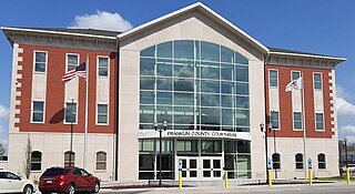
Franklin County is a county in Southern Illinois. At the 2020 census, it had a population of 37,804. The largest city is West Frankfort and the county seat is Benton. This area of Southern Illinois is known locally as "Little Egypt".
Cherry is a village in Bureau County, Illinois, United States. The population was 435 at the 2020 census. It is part of the Ottawa Micropolitan Statistical Area. It is located northwest of LaSalle-Peru, just a few miles north of Interstate 80, and is about 75 miles (121 km) east of the Quad Cities.
Moweaqua is a village in Shelby and Christian counties, Illinois, United States. The population was 1,764 at the 2020 census.
Buckner is a village in Franklin County, Illinois, United States. The population was 409 at the 2020 census. The current mayor is Aaron Eubanks.
Christopher is a city in Franklin County, Illinois, United States. The population was 2,697 at the time of the 2020 census.
Hanaford is a village in Franklin County, Illinois, United States. The population was 320 at the 2020 census. Hanaford is also known as Logan.
Royalton is a village in Franklin County, Illinois, United States. The population was 1,068 at the 2020 census.
Sesser is a city in Franklin County, Illinois, United States. The population was 1,888 at the 2020 census. The current mayor is C. Jason Ashmore.
Thompsonville is a village in Cave Township, Franklin County, Illinois, United States. The population was 486 at the 2020 census.
Valier is a village in Franklin County, Illinois, United States. The population was 554 at the 2020 census.
West City is a village in Franklin County, Illinois, adjacent to the county seat of Benton. The population was 656 at the 2020 census.
Zeigler is a city in Franklin County, Illinois, United States. The population was 1,484 at the 2020 census.
Wenona is a city in Marshall and LaSalle counties in the U.S. state of Illinois. The population was 974 at the 2020 census.
Braidwood is a city in Will County, Illinois, United States, approximately 53 miles (85 km) southwest of Chicago and 18 miles (29 km) south of Joliet. The population was 6,191 at the 2010 census.
Oskaloosa is a city in, and the county seat of, Mahaska County, Iowa, United States. In the late nineteenth and early twentieth century, Oskaloosa was a national center of bituminous coal mining. The population was 11,558 in the 2020 U.S. census.
Coalville is a census-designated place (CDP) in Webster County, Iowa, United States. The population was 610 at the 2010 census. The community is located on U.S. Route 20 near Fort Dodge's large gypsum mines.
Denning Township is one of twelve townships in Franklin County, Illinois, USA. As of the 2020 census, its population was 4,729 and it contained 2,352 housing units.
Frankfort Township is one of twelve townships in Franklin County, Illinois, USA. As of the 2020 census, its population was 6,443 and it contained 3,256 housing units.
This page is based on this Wikipedia article Text is available under the CC BY-SA 4.0 license; additional terms may apply. Images, videos and audio are available under their respective licenses.