Freeman Spur, Illinois

Last updated

Freeman Spur, Illinois
Freeman-Spur-water-tower-il.jpg
Water tower
Williamson County Illinois Incorporated and Unincorporated areas Freeman Spur Highlighted.svg
Location of Freeman Spur in Williamson & Franklin Counties, Illinois.
Illinois in United States (US48).svg
Location of Illinois in the United States
Coordinates: 37°51′36″N89°0′0″W / 37.86000°N 89.00000°W / 37.86000; -89.00000
CountryUnited States
StateIllinois
Counties Williamson, Franklin
Townships Denning, Herrin Precinct
Area
[1]
  Total0.40 sq mi (1.04 km2)
  Land0.40 sq mi (1.03 km2)
  Water0.00 sq mi (0.01 km2)
Elevation
[2]
390 ft (120 m)
Population
 (2020)
  Total268
  Density671.68/sq mi (259.04/km2)
Time zone UTC-6 (CST)
  Summer (DST) UTC-5 (CDT)
ZIP Code
62841
Area code 618
FIPS code 17-27858
GNIS feature ID2398925 [2]
Wikimedia CommonsFreeman Spur, Illinois

Freeman Spur is a village in Williamson and Franklin Counties, Illinois, United States. The population was 268 at the 2020 census. [3]

Contents

History

Freeman Spur is rooted in several small communities that sprang up in the early 1900s with the opening of the Possum Ridge coal mine. These small communities voted to merge and incorporate as "Freeman Spur" in 1913. The village is named for James R. Freeman, who owned the land upon which the mine was located. [4]

Geography

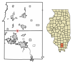
According to the 2021 census gazetteer files, Freeman Spur has a total area of 0.40 square miles (1.04 km2), of which 0.40 square miles (1.04 km2) (or 99.25%) is land and 0.00 square miles (0.00 km2) (or 0.75%) is water. [5]

The shaft of the Possum Ridge Mine, which opened in 1908, is located at Freeman Spur. In 1912, a tornado destroyed above-ground structures at the mine. [6] [7]

Demographics

Historical population
CensusPop.Note
1920 325
1930 277−14.8%
1940 258−6.9%
1950 45174.8%
1960 406−10.0%
1970 363−10.6%
1980 3773.9%
1990 290−23.1%
2000 273−5.9%
2010 2875.1%
2020 268−6.6%
U.S. Census [8]

As of the 2020 census [3] there were 268 people, 88 households, and 58 families residing in the village. The population density was 666.67 inhabitants per square mile (257.40/km2). There were 127 housing units at an average density of 315.92 per square mile (121.98/km2). The racial makeup of the village was 88.06% White, 3.36% African American, 0.00% Native American, 0.00% Asian, 0.00% Pacific Islander, 1.12% from other races, and 7.46% from two or more races. Hispanic or Latino of any race were 0.75% of the population.

There were 88 households, out of which 26.1% had children under the age of 18 living with them, 43.18% were married couples living together, 9.09% had a female householder with no husband present, and 34.09% were non-families. 31.82% of all households were made up of individuals, and 25.00% had someone living alone who was 65 years of age or older. The average household size was 3.83 and the average family size was 3.06.

The village's age distribution consisted of 25.3% under the age of 18, 10.4% from 18 to 24, 17.4% from 25 to 44, 21.6% from 45 to 64, and 25.3% who were 65 years of age or older. The median age was 41.1 years. For every 100 females, there were 118.7 males. For every 100 females age 18 and over, there were 123.3 males.

The median income for a household in the village was $37,750, and the median income for a family was $39,250. Males had a median income of $24,063 versus $13,750 for females. The per capita income for the village was $14,086. About 37.9% of families and 44.6% of the population were below the poverty line, including 55.9% of those under age 18 and 20.6% of those age 65 or over.

Related Research Articles

<span class="mw-page-title-main">Franklin County, Illinois</span> County in Illinois, United States

Franklin County is a county in Southern Illinois. At the 2020 census, it had a population of 37,804. The largest city is West Frankfort and the county seat is Benton. This area of Southern Illinois is known locally as "Little Egypt".

<span class="mw-page-title-main">Buckner, Illinois</span> Village in Illinois, United States

Buckner is a village in Franklin County, Illinois, United States. The population was 409 at the 2020 census. The current mayor is Aaron Eubanks.

<span class="mw-page-title-main">Hanaford, Illinois</span> Village in Illinois, United States

Hanaford is a village in Franklin County, Illinois, United States. The population was 320 at the 2020 census. Hanaford is also known as Logan.

<span class="mw-page-title-main">Sesser, Illinois</span> City in Illinois, United States

Sesser is a city in Franklin County, Illinois, United States. The population was 1,888 at the 2020 census. The current mayor is C. Jason Ashmore.

<span class="mw-page-title-main">Valier, Illinois</span> Village in Illinois, United States

Valier is a village in Franklin County, Illinois, United States. The population was 554 at the 2020 census.

<span class="mw-page-title-main">New Haven, Illinois</span> Village in Illinois, United States

New Haven is a village in Gallatin County, Illinois, United States, along the Little Wabash River near its mouth at the Wabash River. The population was 399 at the 2020 United States Census, down from 433 at the 2010 United States Census.

<span class="mw-page-title-main">Omaha, Illinois</span> Village in Illinois, United States

Omaha is a village in Gallatin County, Illinois, United States. The population was 209 at the 2020 census.

<span class="mw-page-title-main">Cedar Point, Illinois</span> Village in Illinois, United States

Cedar Point is a village in LaSalle County, Illinois, United States. The population was 266 at the 2020 census, down from 277 at the 2010 census. It is part of the Ottawa Micropolitan Statistical Area. North of town was the Cedar Point Mine, which operated from 1906 to 1924.

<span class="mw-page-title-main">Bush, Illinois</span> Village in Illinois, United States

Bush is a village in Williamson County, Illinois, United States. As of the 2000 census, the village population was 257.

<span class="mw-page-title-main">Cambria, Illinois</span> Village in Illinois, United States

Cambria is a village in northwestern Williamson County, Illinois, United States. The population was 1,228 at the 2010 census.

<span class="mw-page-title-main">Colp, Illinois</span> Village in Illinois, United States

Colp is a village in Williamson County, Illinois, United States. The population was 225 at the 2010 census.

<span class="mw-page-title-main">Energy, Illinois</span> Village in Illinois, United States

Energy is a village in Williamson County, Illinois, United States. The population was 974 at the 2020 census. The community was named for local "Energy" brand coal.

<span class="mw-page-title-main">Hurst, Illinois</span> City in Illinois, United States

Hurst is a city in Williamson County, Illinois, United States. The population was 795 at the 2010 census.

<span class="mw-page-title-main">Johnston City, Illinois</span> City in Illinois, United States

Johnston City is a city in Williamson County, Illinois, United States. The population was 3,348 at the 2020 census. This was a center of coal mining in the early 20th century, having a peak of population in the 1920s. The mining jobs attracted many immigrants from Europe.

<span class="mw-page-title-main">Pittsburg, Illinois</span> Village in Illinois, United States

Pittsburg is a village in Williamson County, Illinois. The population was 572 at the 2010 census.

<span class="mw-page-title-main">Spillertown, Illinois</span> Village in Illinois, United States

Spillertown is a village in Williamson County, Illinois, United States. The population was 203 at the 2010 census and as of 2018, the population has grown to an estimated 272.

Whiteash is a Census designated place in Williamson County, Illinois, United States. The population was 268 at the 2000 census, and dropped to 248 in the 2010 census. This village dissolved in 2014.

<span class="mw-page-title-main">Iron Ridge, Wisconsin</span> Village in Wisconsin, United States

Iron Ridge is a village in Dodge County, Wisconsin, United States. The population was 929 at the 2010 census. The village was founded on a railroad line, named for the iron mined in the area. Its ZIP code is 53035.

<span class="mw-page-title-main">Isabel Township, Fulton County, Illinois</span> Township in Illinois, United States

Isabel Township is one of twenty-six townships in Fulton County, Illinois, USA. At the 2020 census, its population was 175 and it contained 97 housing units.

<span class="mw-page-title-main">Denning Township, Franklin County, Illinois</span> Township in Illinois, United States

Denning Township is one of twelve townships in Franklin County, Illinois, USA. As of the 2020 census, its population was 4,729 and it contained 2,352 housing units.

References

  1. "2020 U.S. Gazetteer Files". United States Census Bureau. Retrieved March 15, 2022.
  2. 1 2 U.S. Geological Survey Geographic Names Information System: Freeman Spur, Illinois
  3. 1 2 "Explore Census Data". data.census.gov. Retrieved June 28, 2022.
  4. Barbara Barr Hubbs, "Freeman Spur History," Williamson County Illinois Historical Society website. Accessed June 12, 2021.
  5. Bureau, US Census. "Gazetteer Files". Census.gov. Retrieved June 29, 2022.
  6. Hubbs, Barbara Barr. "Freeman Spur History". Williamson County Illinois Historical Society. Retrieved June 24, 2018.
  7. Hubbs, Barbara Barr. "Possum Ridge Mine History". Williamson County Illinois Historical Society. Retrieved June 24, 2018.
  8. Census of Population and Housing, U.S. Census Bureau