
Marion County is one of the 36 counties in the U.S. state of Oregon. The population was 345,920 at the 2020 census, making it the fifth-most populous county in Oregon. The county seat is Salem, which is also the state capital of Oregon. The county was originally named the Champooick District, after Champoeg, a meeting place on the Willamette River. On September 3, 1849, the territorial legislature renamed it in honor of Francis Marion, a Continental Army general from South Carolina who served in the American Revolutionary War.

Williamson County is a county in Southern Illinois. At the 2020 census, it had a population of 67,153. The largest city and county seat is Marion.
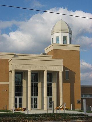
Union County is a county located in the U.S. state of Illinois. According to the 2020 United States Census, it had a population of 17,244. Its county seat is Jonesboro. It is located in the southern portion of Illinois known locally as "Little Egypt".
Johnson County is a county in the U.S. state of Illinois. According to the 2010 census, it has a population of 12,582. Its county seat is Vienna. It is located in the southern portion of Illinois known locally as "Little Egypt".

Jackson County is a county located in the U.S. state of Illinois with a population of 52,974 at the 2020 census. Its county seat is Murphysboro, and its most populous city is Carbondale, home to the main campus of Southern Illinois University. The county was incorporated on January 10, 1816, and named for Andrew Jackson. The community of Brownsville served as the fledgling county's first seat.
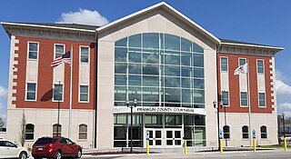
Franklin County is a county in Southern Illinois. At the 2020 census, it had a population of 37,804. The largest city is West Frankfort and the county seat is Benton. This area of Southern Illinois is known locally as "Little Egypt".

Carbondale is a city in Jackson County, Illinois, United States, within the Southern Illinois region informally known as "Little Egypt". The city developed from 1853 because of the stimulation of railroad construction into the area. Today the major roadways of Illinois Route 13 and U.S. Route 51 intersect in the city. The city is 96 miles (154 km) southeast of St. Louis, on the northern edge of the Shawnee National Forest. Carbondale is the home of the main campus of Southern Illinois University (SIU).

Palos Hills is a city in Cook County, Illinois, United States. It is a southwest suburb of Chicago. The city was established in 1958 and had reached a population of 18,530 in the 2020 census. It is the home of Moraine Valley Community College as well as Amos Alonzo Stagg High School.

Freeman Spur is a village in Williamson and Franklin Counties, Illinois, United States. The population was 287 at the 2010 census.

West Frankfort is a city in Franklin County, Illinois. The population was 8,182 at the 2010 census. The city is well known for its rich history of coal. The city is part of the Metro Lakeland area.

Glen Carbon is a village in Madison County, Illinois, United States, 14 miles (23 km) northeast of St. Louis. The population was 13,842 at the 2020 census.

Carterville is a city in Williamson County, Illinois, United States. At the 2020 census, the city's population was 5,848. The city is part of the Carbondale-Marion combined statistical area and has grown considerably as a residential community of Carbondale and Marion.

Energy is a village in Williamson County, Illinois, United States. The population was 1,146 at the 2010 census. The community was named for local "Energy" brand coal.

Herrin is a city in Williamson County, Illinois. The population was 12,352 at the 2020 census. The city is part of the Marion-Herrin Micropolitan Area and is a part of the Carbondale-Marion-Herrin, Illinois Combined Statistical Area with 123,272 residents, the sixth most populous Combined statistical area in Illinois.

Marion is a city in Williamson and Johnson Counties, Illinois, United States, and is the county seat of Williamson County. The population was 16,855 at the 2020 census. It is part of a dispersed urban area that developed out of the early 20th-century coal fields.
Whiteash is a Census designated place in Williamson County, Illinois, United States. The population was 268 at the 2000 census, and dropped to 248 in the 2010 census. This village dissolved in 2014.

North Potomac is a census-designated place and unincorporated area in Montgomery County, Maryland, United States. It is located less than 5 miles (8.0 km) north of the Potomac River, and is about 20 miles (32 km) from Washington, D.C. It has a population of 23,790 as of 2020.

Crab Orchard is a census-designated place (CDP) in Raleigh County, West Virginia, United States. The population was 2,678 at the 2010 census.
Dykersburg is an unincorporated community in eastern Williamson County, Illinois in what is now Crab Orchard Precinct. It was also known as Absher, though that name had fallen into disuse by the mid 20th century.
Crab Orchard Community Unit School District 3 is a school district headquartered in Crab Orchard, Illinois. Crab Orchard Community Unit School District #3 serves the community and surrounding area. The district provides classes from Kindergarten to 12th grade. The schools teams have been known as the "Trojans."


