
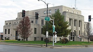
Williamson County is a county in Southern Illinois. At the 2020 census, it had a population of 67,153. The largest city and county seat is Marion.
Jefferson County is a county located in the southern part of the U.S. state of Illinois. According to the 2020 census, it has a population of 37,113. The county seat is Mount Vernon.

Jackson County is a county located in the U.S. state of Illinois with a population of 52,974 at the 2020 census. Its county seat is Murphysboro, and its most populous city is Carbondale, home to the main campus of Southern Illinois University. The county was incorporated on January 10, 1816, and named for Andrew Jackson. The community of Brownsville served as the fledgling county's first seat.

Gallatin County is a county located in the U.S. state of Illinois. According to the 2020 census, it has a population of 4,946, making it the third-least populous county in Illinois. Its county seat is Shawneetown. It is located in the southern portion of Illinois known locally as Little Egypt. Located at the mouth of the Wabash River, Gallatin County, along with neighboring Posey County, Indiana, and Union County, Kentucky form the tri-point of the Illinois-Indiana-Kentucky Tri-State Area.
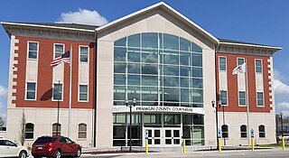
Franklin County is a county in Southern Illinois. At the 2020 census, it had a population of 37,804. The largest city is West Frankfort and the county seat is Benton. This area of Southern Illinois is known locally as "Little Egypt".

Calhoun County is a county in the U.S. state of Illinois. As of the 2020 census, the population was 4,437, making it Illinois’ third-least populous county. Its county seat and biggest community is Hardin, with a population of 801. Its smallest incorporated community is Hamburg, with a population of 99. Calhoun County is at the tip of the peninsula formed by the courses of the Mississippi and Illinois rivers above their confluence and is almost completely surrounded by water. Calhoun County is sparsely populated; it has just five municipalities, all of them villages.

Centralia is a city in Clinton, Jefferson, Marion, and Washington counties in the U.S. state of Illinois with the largest portion in Marion County. The city is the largest in three of the counties; Clinton, Marion, and Washington, but is not a county seat of any of them. The population was 12,182 as of the 2020 census, down from 13,032 in 2010.

Equality is a village in Gallatin County, Illinois, United States. The population was 595 at the 2010 census, down from 721 at the 2000 census. Near the village are two points of interest, the Crenshaw House and the Garden of the Gods Wilderness. Equality was the county seat of Gallatin County from 1826–1851.

Junction is a village in Gallatin County, Illinois, United States. The population was 56 at the 2020 census.

Herrin is a city in Williamson County, Illinois. The population was 12,352 at the 2020 census. The city is part of the Marion-Herrin Micropolitan Area and is a part of the Carbondale-Marion-Herrin, Illinois Combined Statistical Area with 123,272 residents, the sixth most populous Combined statistical area in Illinois.

Southern Illinois, also known as Little Egypt, is a region of the U.S. state of Illinois comprising the southern third of the state, principally along and south of Interstate 64. Part of downstate Illinois, it is bordered by the two most voluminous rivers in the United States: the Mississippi below its connecting Missouri River to the west and the Ohio River to the east and south, with the Wabash as a tributary.

The Herrin massacre took place on June 21–22, 1922 in Herrin, Illinois, in a coal mining area during a nationwide strike by the United Mineworkers of America (UMWA). Although the owner of the mine originally agreed with the union to observe the strike, when the price of coal went up, he hired non-union workers to produce and ship out coal, as he had high debt in start-up costs.

Buffalo Grove is an unincorporated community in the Ogle County township of Buffalo, Illinois, United States. It was the first settlement in Ogle County, and was once a bustling frontier town that attracted many of Ogle County's early residents. The creation of the Illinois Central Railroad, caused most of the residents and businesses to move to Polo. Today this former hub of business comprises a few dozen homes.
Marion Station, also known as Marion, is an unincorporated community in Somerset County, Maryland, United States. It is located at the northern intersection of Maryland routes 413 and 667. After the arrival of the Pennsylvania Railroad arm known as the "Eastern Shore Railroad" toward Crisfield in 1866, Marion was locally hailed as the "strawberry capital of the world". After the trains stopped coming it went into decline, with some sources even hailing it as a ghost town.
Hartland, elevation 922 feet, is an unincorporated community and census-designated place in McHenry County, Illinois, United States. It was named a CDP before the 2020 census, at which time it had a population of 157.

Summum is an unincorporated community in Fulton County, Illinois, United States. Summum is located adjacent to U.S. Highway 24 northeast of Astoria, in Woodland Township.
Elliston is an unincorporated community in Fairplay Township, Greene County, Indiana, United States.
Liberty is an unincorporated community in Harrisburg Township, Saline County, Illinois, United States. Liberty is located on County Route 37 along the southwestern border of Harrisburg.

Antares is an unincorporated community and census designated place (CDP) in Mohave County, Arizona, United States. As of the 2020 census, it had a population of 132. It exists along part of historic U.S. Route 66.


