Carterville, Illinois

Last updated

Carterville, Illinois
Carterville-Division-Street-il.jpg
Division St
Williamson County Illinois Incorporated and Unincorporated areas Carterville Highlighted.svg
Location of Carterville in Williamson County, Illinois.
Illinois in United States (US48).svg
Location of Illinois in the United States
Coordinates: 37°45′40.03″N89°4′46.52″W / 37.7611194°N 89.0795889°W / 37.7611194; -89.0795889
CountryUnited States
StateIllinois
County Williamson
Government
  MayorBradley Robinson
Area
[1]
  Total5.35 sq mi (13.86 km2)
  Land5.27 sq mi (13.64 km2)
  Water0.08 sq mi (0.22 km2)
Elevation
[2]
443 ft (135 m)
Population
 (2020)
  Total5,848
  Density1,110.52/sq mi (428.78/km2)
Time zone UTC-6 (CST)
  Summer (DST) UTC-5 (CDT)
ZIP Code
62918
Area code 618
FIPS code 17-11514
GNIS feature ID2393757 [2]
Wikimedia CommonsCarterville, Illinois
Website www.visitcarterville.com

Carterville is a city in Williamson County, Illinois, United States. At the 2020 census, the city's population was 5,848. The city is part of the Carbondale-Marion-Herrin combined statistical area and has grown considerably as a residential community of Carbondale and Marion.

Contents

The city is located next to Crab Orchard National Wildlife Refuge. The Refuge's 44,000 acres (180 km2) of land and water contain a wide diversity of flora and fauna. [3]

History

Carterville was founded by George Monroe McNeill and Laban Carter. McNeill married Olive Herrin of Herrin's Prairie and in 1866 they settled on the farm now known as Carterville. Carter came to Williamson County in 1864, purchased 100 acres (0.40 km2) of land, and helped organize and secure a post office for Carterville in 1871. The town was named in his honor. [4] McNeill was one of the youngest members of the Union army during the American Civil War. He enlisted at 16 and was with General William T. Sherman during his March to the Sea. [4]

Geography

According to the 2010 census, the city has a total area of 5.28 square miles (13.7 km2), of which 5.19 square miles (13.4 km2) (or 98.30%) is land and 0.09 square miles (0.23 km2) (or 1.70%) is water. [5]

Demographics

Historical population
CensusPop.Note
1880 692
1890 96940.0%
1900 1,74980.5%
1910 2,97169.9%
1920 3,40414.6%
1930 2,866−15.8%
1940 2,8930.9%
1950 2,716−6.1%
1960 2,643−2.7%
1970 3,06115.8%
1980 3,44512.5%
1990 3,6305.4%
2000 4,61627.2%
2010 5,49619.1%
2020 5,8486.4%
U.S. Census [6]

As of the census [7] of 2000, there were 4,616 people, 1,933 households, and 1,293 families residing in the city. The population density was 1,061.8 inhabitants per square mile (410.0/km2). There were 2,093 housing units at an average density of 481.5 per square mile (185.9/km2). The racial makeup of the city was 96.21% White, 1.13% African American, 0.15% Native American, 0.93% Asian, 0.02% Pacific Islander, 0.58% from other races, and 0.97% from two or more races. Hispanic or Latino of any race were 1.13% of the population.

There were 1,933 households, out of which 32.1% had children under the age of 18 living with them, 54.4% were married couples living together, 10.0% had a female householder with no husband present, and 33.1% were non-families. 28.0% of all households were made up of individuals, and 10.8% had someone living alone who was 65 years of age or older. The average household size was 2.39 and the average family size was 2.95.

In the city the population was spread out, with 25.2% under the age of 18, 10.0% from 18 to 24, 28.1% from 25 to 44, 23.1% from 45 to 64, and 13.6% who were 65 years of age or older. The median age was 36 years. For every 100 females, there were 93.9 males. For every 100 females age 18 and over, there were 91.0 males.

The median income for a household in the city was $36,969, and the median income for a family was $44,722. Males had a median income of $34,231 versus $24,924 for females. The per capita income for the city was $18,884. About 9.9% of families and 14.6% of the population were below the poverty line, including 15.4% of those under age 18 and 7.1% of those age 65 or over.

Education

Carterville is home to John A. Logan College, named for the local American Civil War hero and politician John A. Logan. A college of approximately 8,000 students, John A. Logan College was featured in Rolling Stone magazine as the nation's fifth best community college and in 2004 was recognized as one of the fastest growing community colleges in the nation. [8]

Carterville High School received a silver medal and ranked 94th in Illinois on U.S. News & World Report's 2016 list of the nation's best high schools. CHS was the only public high school in southern Illinois that performed above the state average of 21 on ACT testing. [9]

The Carterville Unit 5 Schools' athletic programs have been successful in the past, winning the IHSA State Conference Championship in Class 3A football in 1996 and in Class 2A softball in 2008 and 2016. The Carterville Varsity Cheer squad hold the record for the most wins in IHSA history. [10]

Notable people

Related Research Articles

<span class="mw-page-title-main">Williamson County, Illinois</span> County in Illinois, United States

Williamson County is a county in Southern Illinois. At the 2020 census, it had a population of 67,153. The largest city and county seat is Marion.

<span class="mw-page-title-main">Union County, Illinois</span> County in Illinois, United States

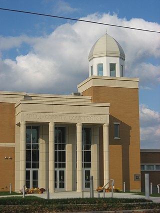
Union County is a county located in the U.S. state of Illinois. According to the 2020 United States Census, it had a population of 17,244. Its county seat is Jonesboro. It is located in the southern portion of Illinois known locally as "Little Egypt".

<span class="mw-page-title-main">Johnson County, Illinois</span> County in Illinois, United States

Johnson County is a county in the U.S. state of Illinois. According to the 2020 census, it has a population of 13,308. Its county seat is Vienna. It is located in the southern portion of Illinois known locally as "Little Egypt".

<span class="mw-page-title-main">Jackson County, Illinois</span> County in Illinois, United States

Jackson County is a county located in the U.S. state of Illinois with a population of 52,974 at the 2020 census. Its county seat is Murphysboro, and its most populous city is Carbondale, home to the main campus of Southern Illinois University. The county was incorporated on January 10, 1816, and named for Andrew Jackson. The community of Brownsville served as the fledgling county's first seat.

<span class="mw-page-title-main">New Haven, Illinois</span> Village in Illinois, United States

New Haven is a village in Gallatin County, Illinois, United States, along the Little Wabash River near its mouth at the Wabash River. The population was 433 at the 2010 United States Census, down from 477 at the 2000 census.

<span class="mw-page-title-main">Old Shawneetown, Illinois</span> Village in Illinois, United States

Old Shawneetown is a village in Gallatin County, Illinois, United States. As of the 2010 census, the village had a population of 193, down from 278 at the 2000 census. Located along the Ohio River, Shawneetown served as an important United States government administrative center for the Northwest Territory. The village was devastated by the Ohio River flood of 1937. The village's population was moved several miles inland to New Shawneetown.

<span class="mw-page-title-main">Shawneetown, Illinois</span> City in Illinois, United States

Shawneetown is a city in Gallatin County, Illinois, United States. The population was 1,239 at the 2010 census, down from 1,410 at the 2000 census. It is the county seat of Gallatin County.

<span class="mw-page-title-main">Atlanta, Illinois</span> City in Illinois, United States

Atlanta is a city in Logan County, Illinois, United States. The population was 1,692 at the 2010 census.

<span class="mw-page-title-main">Cambria, Illinois</span> Village in Illinois, United States

Cambria is a village in northwestern Williamson County, Illinois, United States. The population was 1,228 at the 2010 census.

<span class="mw-page-title-main">Crainville, Illinois</span> Village in Illinois, United States

Crainville is a village in Williamson County, Illinois, United States. The population was 1,254 at the 2010 census.

<span class="mw-page-title-main">Creal Springs, Illinois</span> City in Illinois, United States

Creal Springs is a city in Williamson County, Illinois, United States. The population was 543 at the 2010 census.

<span class="mw-page-title-main">Herrin, Illinois</span> Place in Illinois, United States

Herrin is a city in Williamson County, Illinois. The population was 12,352 at the 2020 census. The city is part of the Marion-Herrin Micropolitan Area and is a part of the Carbondale-Marion-Herrin, Illinois Combined Statistical Area with 123,272 residents, the sixth most populous Combined statistical area in Illinois.

<span class="mw-page-title-main">Hurst, Illinois</span> City in Illinois, United States

Hurst is a city in Williamson County, Illinois, United States. The population was 795 at the 2010 census.

<span class="mw-page-title-main">Marion, Illinois</span> City in Illinois, United States

Marion is a city in Williamson and Johnson Counties, Illinois, United States, and is the county seat of Williamson County. The population was 16,855 at the 2020 census. It is part of a dispersed urban area that developed out of the early 20th-century coal fields.

<span class="mw-page-title-main">Spillertown, Illinois</span> Village in Illinois, United States

Spillertown is a village in Williamson County, Illinois, United States. The population was 203 at the 2010 census and as of 2018, the population has grown to an estimated 272.

<span class="mw-page-title-main">Crab Orchard, Kentucky</span> City in Kentucky, United States

Crab Orchard is a home rule-class city in Lincoln County, Kentucky, United States. The population was 841 at the 2010 census. It is part of the Danville Micropolitan Statistical Area.

<span class="mw-page-title-main">Carterville, Missouri</span> City in Missouri, United States

Carterville is a city in Jasper County, Missouri, United States. The population was 1,855 at the 2020 census. It is part of the Joplin, Missouri Metropolitan Statistical Area.

<span class="mw-page-title-main">Crab Orchard, Nebraska</span> Village in Nebraska, United States

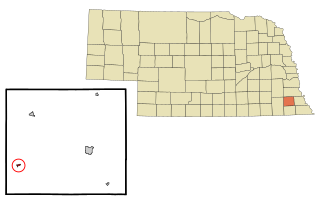
Crab Orchard is a village in Johnson County, Nebraska, United States. As of the 2020 census, the village population was 47.

<span class="mw-page-title-main">Crab Orchard, Tennessee</span> City in Tennessee, United States

Crab Orchard is a city in Cumberland County, Tennessee, United States. The population was 719 at the 2020 census.

<span class="mw-page-title-main">Crab Orchard, Illinois</span> Census-designated place in Illinois, United States

Crab Orchard is an unincorporated census-designated place east of Marion in Williamson County, Illinois, located along an old route of Illinois Route 13 now designated Crab Orchard Road. The upper branches of Crab Orchard Creek which eventually feed into Crab Orchard Lake flow nearby and gave the community its name. For a brief time during the Civil War, it was known as Erwinsville, which is the name in the original plat of the village. In its early days, it had the nickname "Steal-Easy." The Crab Orchard post office was established 18 August 1853 and discontinued operations 15 May 1924. It's now served by the Marion post office. As of the 2010 census, Crab Orchard has a population of 333. Crab Orchard has an area of 1.430 square miles (3.70 km2); 1.395 square miles (3.61 km2) of this is land, and 0.035 square miles (0.091 km2) is water.

References

  1. "2020 U.S. Gazetteer Files". United States Census Bureau. Retrieved March 15, 2022.
  2. 1 2 U.S. Geological Survey Geographic Names Information System: Carterville, Illinois
  3. Walker, T. "Crab Orchard National Wildlife Refuge". State Parks. Retrieved August 31, 2021.
  4. 1 2 "Cssbonline - Community". Archived from the original on February 6, 2007. Retrieved April 30, 2007.
  5. "Places: Illinois". 2010 Census Gazetteer Files. United States Census Bureau. Archived from the original on October 21, 2013. Retrieved May 3, 2012.
  6. Census of Population and Housing, U.S. Census Bureau
  7. "U.S. Census website". United States Census Bureau . Retrieved January 31, 2008.
  8. "HerrinFesta Italiana 2007 - Where the Food, Fun, & Entertainment are Primo!". Archived from the original on July 3, 2007. Retrieved December 16, 2007.
  9. Halstead, Marilyn (April 22, 2016). "Carterville School District sets high expectations". The Southern. Retrieved August 31, 2021.
  10. http://www.ihsa.org/activity/fb/records/team1-2.htm [ bare URL ]

Further reading