Pulleys Mill, Illinois | |
|---|---|
 Pulleys Mill, Illinois  Pulleys Mill, Illinois | |
| Coordinates: 37°36′00″N88°58′46″W / 37.60000°N 88.97944°W | |
| Country | United States |
| State | Illinois |
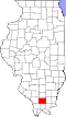
| County | Williamson |
| Elevation | 597 ft (182 m) |
| Time zone | UTC-6 (Central (CST)) |
| • Summer (DST) | UTC-5 (CDT) |
| ZIP Code | 62939 |
| Area code | 618 |
| GNIS feature ID | 1736162 [1] |
Pulleys Mill is an unincorporated community in Williamson County, Illinois. [2] It is generally located north of Goreville, near the western terminus of Interstate 24 at Interstate 57.
The area was named after Barton S. Pulley, and had a post office from October 28, 1864, to July 14, 1905. Mail is now routed through the nearby town of Goreville. [3] [4]