Stonefort | |
---|---|
Coordinates: 37°37′0″N88°42′26″W / 37.61667°N 88.70722°W Coordinates: 37°37′0″N88°42′26″W / 37.61667°N 88.70722°W | |
Country | United States |
State | Illinois |
County | Saline, Williamson |
Area | |
• Total | 1.46 sq mi (3.78 km2) |
• Land | 1.45 sq mi (3.77 km2) |
• Water | 0.01 sq mi (0.01 km2) |
Elevation | 404 ft (123 m) |
Population (2020) | |
• Total | 224 |
• Density | 154.06/sq mi (59.49/km2) |
Time zone | UTC-6 (CST) |
• Summer (DST) | UTC-5 (CDT) |
ZIP Code | 62987 |
Area code | 618 |
FIPS code | 17-72884 |
GNIS feature ID | 2399909 [2] |
Wikimedia Commons | Stonefort, Illinois |
Stonefort is a village in Saline and Williamson Counties, Illinois, United States. The population was 297 at the 2010 census.
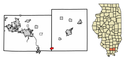
Stonefort is named for an ancient rock fortification that stood in the vicinity when the first settlers started arriving in the area in the early 1800s. The village of Stonefort was established in the late 1850s, and was originally located about a mile to the southeast, near the edge of the bluff. When the Cairo and Vincennes Railroad (later part of the Big Four and New York Central systems) was completed through the area in the 1870s, Stonefort's public buildings were dismantled and moved to the village's present location, which was adjacent to the railroad tracks. The former site of the village is now listed as "Oldtown" on maps. [3]
Stonefort is located at 37°37′0″N88°42′26″W / 37.61667°N 88.70722°W (37.616615, -88.707143). [4] The village is situated atop a ridge that rises above the South Fork Saline River valley to the north and the Little Saline River valley to the south. U.S. Route 45 connects Stonefort with Carrier Mills to the northeast and New Burnside to the southwest. The Tunnel Hill State Trail, a 45-mile (72 km) rail trail, traverses Stonefort.
According to the 2010 census, Stonefort has a total area of 1.456 square miles (3.77 km2), of which 1.45 square miles (3.76 km2) (or 99.59%) is land and 0.006 square miles (0.02 km2) (or 0.41%) is water. [5]
Historical population | |||
---|---|---|---|
Census | Pop. | %± | |
1880 | 337 | — | |
1890 | 464 | 37.7% | |
1900 | 479 | 3.2% | |
1910 | 485 | 1.3% | |
1920 | 456 | −6.0% | |
1930 | 487 | 6.8% | |
1940 | 524 | 7.6% | |
1950 | 490 | −6.5% | |
1960 | 349 | −28.8% | |
1970 | 325 | −6.9% | |
1980 | 316 | −2.8% | |
1990 | 311 | −1.6% | |
2000 | 292 | −6.1% | |
2010 | 297 | 1.7% | |
2020 | 224 | −24.6% | |
U.S. Census [6] |
As of the census [7] of 2010, there were 297 people, 131 households, and 89 families residing in the village. The population density was 199.9 inhabitants per square mile (77.2/km2). There were 144 housing units at an average density of 98.6 per square mile (38.1/km2). The racial makeup of the village was 97.60% White, 1.03% African American, 1.03% from other races, and 0.34% from two or more races. Hispanic or Latino of any race were 1.71% of the population.
There were 131 households, out of which 24.4% had children under the age of 18 living with them, 53.4% were married couples living together, 9.9% had a female householder with no husband present, and 31.3% were non-families. 30.5% of all households were made up of individuals, and 19.1% had someone living alone who was 65 years of age or older. The average household size was 2.23 and the average family size was 2.70.
In the village, the population was spread out, with 19.2% under the age of 18, 4.5% from 18 to 24, 22.9% from 25 to 44, 29.5% from 45 to 64, and 24.0% who were 65 years of age or older. The median age was 47 years. For every 100 females, there were 82.5 males. For every 100 females age 18 and over, there were 84.4 males.
The median income for a household in the village was $28,654, and the median income for a family was $31,442. Males had a median income of $38,125 versus $22,083 for females. The per capita income for the village was $16,937. About 6.0% of families and 16.9% of the population were below the poverty line, including 6.3% of those under the age of eighteen and 18.0% of those 65 or over.
Williamson County is a county in Southern Illinois. At the 2020 census, it had a population of 67,153. The largest city and county seat is Marion.
Saline County is a county in Southern Illinois. At the 2020 census, it had a population of 23,768. The largest city and county seat is Harrisburg. This area of Southern Illinois is known locally as "Little Egypt".
Hanaford is a village in Franklin County, Illinois, United States. The population was 320 at the 2020 census. Hanaford is also known as Logan.
Thompsonville is a village in Cave Township, Franklin County, Illinois, United States. The population was 543 at the 2010 census.
Equality is a village in Gallatin County, Illinois, United States. The population was 595 at the 2010 census, down from 721 at the 2000 census. Near the village are two points of interest, the Crenshaw House and the Garden of the Gods Wilderness. Equality was the county seat of Gallatin County from 1826–1851.
Junction is a village in Gallatin County, Illinois, United States. The population was 129 at the 2010 census.
New Haven is a village in Gallatin County, Illinois, United States, along the Little Wabash River near its mouth at the Wabash River. The population was 433 at the 2010 United States Census, down from 477 at the 2000 census.
Old Shawneetown is a village in Gallatin County, Illinois, United States. As of the 2010 census, the village had a population of 193, down from 278 at the 2000 census. Located along the Ohio River, Shawneetown served as an important United States government administrative center for the Northwest Territory. The village was devastated by the Ohio River flood of 1937. The village's population was moved several miles inland to New Shawneetown.
Omaha is a village in Gallatin County, Illinois, United States. The population was 266 at the 2010 census.
Ridgway is a village in Gallatin County, Illinois, United States. As of the 2020 census, the population was 851. As of 2018, Rebecca Mitchell was the town mayor.
Elizabethtown is a village in and the county seat of Hardin County, Illinois, United States, along the Ohio River. The population was 299 at the 2010 census, down from 348 at the 2000 census. It is the least-populous county seat in the state.
Goreville is a village in Johnson County, Illinois, United States. The population was 1,049 as of the 2010 census, up from 938 at the 2000 census.
New Burnside is a village in Johnson County, Illinois, United States. The population was 211 at the 2010 census.
Long Point is a village in Livingston County, Illinois, United States. The population was 226 at the 2010 census.
New Salem is a village in Pike County, Illinois, United States. The population was 136 at the 2000 census.
Galatia is a village in Saline County, Illinois, in the United States. As of the 2010 census, the village population was 933.
Muddy is a small incorporated village located in the Harrisburg Township in Saline County, Illinois, United States. The population was 78 at the 2000 census.
Raleigh is a village in Saline County, Illinois, United States. The population was 330 at the 2000 census.
Pittsburg is a village in Williamson County, Illinois. The population was 572 at the 2010 census.
LeRoy Township is a township in Bradford County, Pennsylvania, United States. It is part of Northeastern Pennsylvania. The population was 718 at the 2010 census.