Related Research Articles

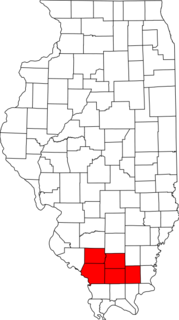
Williamson County is a county in Southern Illinois. At the 2020 census, it had a population of 67,153. The largest city and county seat is Marion.
Cambria is a village in Williamson County, Illinois, United States. The population was 1,228 at the 2010 census.

Carterville is a city in Williamson County, Illinois, United States. At the 2020 census, the city's population was 5,848. The city is part of the Carbondale-Marion combined statistical area and has grown considerably as a residential community of Carbondale and Marion.

Crainville is a village in Williamson County, Illinois, United States. The population was 1,254 at the 2010 census.

Herrin is a city in Williamson County, Illinois. The population was 12,352 at the 2020 census. The city is part of the Marion-Herrin Micropolitan Area and is a part of the Carbondale-Marion-Herrin, Illinois Combined Statistical Area with 123,272 residents, the sixth most populous Combined statistical area in Illinois.
Metro Lakeland is a name that was coined in the 1960s for an area of southern Illinois that is centered on the intersections of Interstate 57, Interstate 24, and Illinois Route 13 — a four-lane east-west highway connecting the communities of Murphysboro, Carbondale, Carterville, Herrin, Marion, and Harrisburg. Metro Lakeland was defined as Jackson, Williamson, Franklin, Saline, and Perry counties, with a combined population of approximately 210,000. Carbondale, Herrin, and Marion are the key urban areas, with a combined city-proper population of over 65,000 Carbondale, the site of Southern Illinois University, is the region's largest city. Metro Lakeland is about 88 miles (142 km) southeast of St. Louis, Missouri, or 120 miles (190 km) by Interstate highway.

Ora Township is one of sixteen townships in Jackson County, Illinois, USA. As of the 2010 census, its population was 514 and it contained 210 housing units.
Dewmaine was an unincorporated African-American coal-mining community in Williamson County, Illinois. Today the area is almost completely non-residential and vacant land, though it now sits at the northern edge of Carterville. Its name is an amalgamation of Admiral Dewey and the USS Maine from the Spanish–American War.
Blairsville Precinct, formerly township, is Congressional Township 8 South, Range 1 East of the Third Principal Meridian located in Williamson County, Illinois. It is named for the village of Blairsville, Illinois.
West Marion Precinct, formerly township, is Congressional Township 9 South, Range 2 East of the Third Principal Meridian located in Williamson County, Illinois. It is named for the community of Marion, Illinois.
East Marion Precinct, formerly township, is Congressional Township 9 South, Range 3 East of the Third Principal Meridian located in Williamson County, Illinois. It is named for the community of Marion, Illinois.
Crab Orchard Precinct, formerly township, is Congressional Township 9 South, Range 4 East of the Third Principal Meridian located in Williamson County, Illinois. It is named for the community of Crab Orchard, Illinois.
Creal Springs Precinct, formerly township, is Congressional Township 10 South, Range 3 East of the Third Principal Meridian located in Williamson County, Illinois. It is named for the community of Creal Springs, Illinois.
Corinth Precinct, formerly township, is Congressional Township 8 South, Range 4 East of the Third Principal Meridian located in Williamson County, Illinois. It is named for the historical community of Corinth, Illinois. It was first known as Northern Precinct.
Southern Precinct, formerly township, is Congressional Township 10 South, Range 2 East of the Third Principal Meridian located in Williamson County, Illinois. Its name is generic as there have never been any large communities or trade centers within it, though it is home to Pulley's Mill. The most well-known institution that lies within the precinct is the United States Penitentiary, Marion, which lies in the north-central part of the precinct. The Lake of Egypt Dam is also located in the Precinct, as is the northwestern part of the lake itself. The 2010 census reported a population of 3,273 inhabitants in Southern Precinct. The nearest city is Marion, Illinois, not far to its north-northeast.
Stonefort Precinct, formerly township, is Congressional Township 10 South, Range 4 East of the Third Principal Meridian located in Williamson County, Illinois. It is named for the community of Stonefort, Illinois.
Grassy Precinct, formerly township, is Congressional Township 10 South, Range 1 East of the Third Principal Meridian located in Williamson County, Illinois. It is named for Grassy Creek, which has since been used to create Little Grassy Lake.
Herrin Precinct, formerly township, is Congressional Township 8 South, Range 2 East of the Third Principal Meridian located in Williamson County, Illinois. It is named for the community of Herrin, Illinois.
Lake Creek Precinct, formerly township, is Congressional Township 8 South, Range 3 East of the Third Principal Meridian located in Williamson County, Illinois. It is named for Lake Creek. The largest community within the precinct is Johnston City, Illinois.
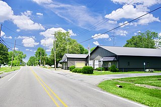
Halfway, Illinois was an unincorporated community in northeastern Williamson County, Illinois located about halfway between the county seat of Marion and Corinth. A post office operated from 1895 to 1911 in a country store. The ZIP Code was 62974.
References
- ↑ 2005. Williamson County, IL, Land Atlas & Plat Book. St. Cloud, Minn.: Cloud Cartographics. 18.
Municipalities and communities of Williamson County, Illinois, United States | ||
|---|---|---|
| Cities |  | |
| Villages | ||
| Precincts | ||
| CDPs | ||
| Other communities | ||
| Ghost towns | ||
| Footnotes | ‡This populated place also has portions in an adjacent county or counties | |
Coordinates: 37°43′49″N89°05′46″W / 37.73028°N 89.09611°W
| | This Williamson County, Illinois location article is a stub. You can help Wikipedia by expanding it. |