Johnston City, Illinois

Last updated
Johnston City
Johnston-City-from-tracks-il.jpg
Johnston City
Williamson County Illinois Incorporated and Unincorporated areas Johnston City Highlighted.svg
Location of Johnston City in Williamson County, Illinois.
Illinois in United States (US48).svg
Location of Illinois in the United States
Coordinates: 37°49′15″N88°55′39″W / 37.82083°N 88.92750°W / 37.82083; -88.92750 Coordinates: 37°49′15″N88°55′39″W / 37.82083°N 88.92750°W / 37.82083; -88.92750
CountryUnited States
StateIllinois
County Williamson
Area
[1]
  Total2.17 sq mi (5.63 km2)
  Land2.12 sq mi (5.48 km2)
  Water0.06 sq mi (0.15 km2)
Elevation
[2]
440 ft (130 m)
Population
 (2020)
  Total3,384
  Density1,599.24/sq mi (617.47/km2)
Time zone UTC-6 (CST)
  Summer (DST) UTC-5 (CDT)
ZIP Code
62951
Area code 618
FIPS code 17-38544
GNIS feature ID2395475 [2]
Wikimedia CommonsJohnston City, Illinois

Johnston City is a city in Williamson County, Illinois, United States. The population was 3,348 at the 2020 census. This was a center of coal mining in the early 20th century, having a peak of population in the 1920s. The mining jobs attracted many immigrants from Europe.

Contents

History

Johnston City was founded in 1894 as a stop along the Chicago, Paducah and Memphis Railroad (later part of the Chicago and Eastern Illinois), and named for the contracting firm that constructed the railroad. [3]

The eastern part of the city was originally known as Jeffersonville. It was surveyed in 1853. During the American Civil War it was a prosperous village. The post office was established in 1852 under the name Lake Creek. It was moved to Johnston City in 1903 but it was not until several years after that that Jeffersonville was fully amalgamated into Johnston City. [4]

In the late 19th and early 20th centuries, a number of immigrant miners from Italy, Wales and other areas arrived to work in the coal mines. There were tensions among the different ethnic groups, especially when miners went out on strike for better wages and conditions.[ citation needed ]

On June 10, 1915, the city was the site of the lynching of Joe Strando, an Italian immigrant miner from Sicily, by a mob of 300 American men. He was taken from the jail where he was held as a suspect in the murder of Edward Chapman, a wealthy local citizen, and wounding of his daughter. [5] Sicilians were outraged and gathered reinforcements; Americans were arrayed against them. The governor sent in three companies of militia to suppress violence. [5] Six years later, immigrant Settino de Santis confessed to the murder of Chapman, saying that the man was accidentally shot while visiting at the home of mine foreman Ben Schull. De Santis and two other men shot at Schull in retaliation for having been fired. De Santis confessed before he was executed in another capital case.[ citation needed ]

With the decline of mining, the number of jobs fell. By 1940 the city's population was just under 4,000. For 2015 the US Census estimated the population at 3500. [6]

In the 1960s a decline in coal miners occurred due to safety standards in the coal mines.[ citation needed ]

Geography

Johnston City is located at 37°49′15″N88°55′39″W / 37.820747°N 88.927529°W / 37.820747; -88.927529 . [7]

According to the 2010 census, Johnston City has a total area of 2.12 square miles (5.49 km2), of which 2.06 square miles (5.34 km2) (or 97.17%) is land and 0.06 square miles (0.16 km2) (or 2.83%) is water. [8]

Demographics

Historical population
CensusPop.
1900 787
1910 3,248312.7%
1920 7,137119.7%
1930 5,945−16.7%
1940 5,418−8.9%
1950 4,479−17.3%
1960 3,891−13.1%
1970 3,9822.3%
1980 3,873−2.7%
1990 3,706−4.3%
2000 3,557−4.0%
2010 3,5650.2%
2020 3,348−6.1%
U.S. Census [9]

As of the census [10] of 2000, there were 3,557 people, 1,560 households, and 1,010 families residing in the city. The population density was 1,820.9 inhabitants per square mile (703.1/km2). There were 1,745 housing units at an average density of 893.3 per square mile (344.9/km2). The racial makeup of the city was 99.07% White, 0.11% African American, 0.14% Native American, 0.06% Asian, 0.08% from other races, and 0.53% from two or more races. Hispanic or Latino of any race were 1.07% of the population.

There were 1,560 households, out of which 27.9% had children under the age of 18 living with them, 47.8% were married couples living together, 13.5% had a female householder with no husband present, and 35.2% were non-families. 31.8% of all households were made up of individuals, and 17.4% had someone living alone who was 65 years of age or older. The average household size was 2.28 and the average family size was 2.86.

In the city, the population was spread out, with 22.8% under the age of 18, 7.9% from 18 to 24, 27.1% from 25 to 44, 23.5% from 45 to 64, and 18.7% who were 65 years of age or older. The median age was 39 years. For every 100 females, there were 85.5 males. For every 100 females age 18 and over, there were 81.1 males.

The median income for a household in the city was $25,143, and the median income for a family was $32,363. Males had a median income of $30,038 versus $16,853 for females. The per capita income for the city was $12,764. About 19.6% of families and 22.5% of the population were below the poverty line, including 26.9% of those under age 18 and 17.1% of those age 65 or over.

Related Research Articles

<span class="mw-page-title-main">Lamoille County, Vermont</span> County in Vermont, United States

Lamoille County is a county located in the U.S. state of Vermont. As of the 2020 census, the population was 25,945, and it is the third-least populous county in Vermont. Its shire town is the town of Hyde Park, while Morristown is the county's largest town by population as well as its main commercial center. The county was created in 1835 from portions of Orleans, Franklin, Washington, and Chittenden Counties and organized the following year.

<span class="mw-page-title-main">Williamson County, Illinois</span> County in Illinois, United States

Williamson County is a county in Southern Illinois. At the 2020 census, it had a population of 67,153. The largest city and county seat is Marion.

<span class="mw-page-title-main">Panama, Illinois</span> Village in Illinois, United States

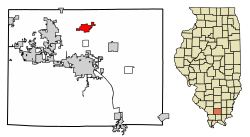
Panama is a village in Montgomery and Bond counties, Illinois, United States. The population was 337 at the 2020 census.

<span class="mw-page-title-main">Arlington, Illinois</span> Village in Illinois, United States

Arlington is a village in Bureau County, Illinois, United States. The population was 169 at the 2020 census. It is part of the Ottawa Micropolitan Statistical Area, located east of the Quad Cities, north of Peoria and Galesburg, west of LaSalle and Peru, and southwest of Rockford and Chicago.

<span class="mw-page-title-main">Cherry, Illinois</span> Village in Illinois, United States

Cherry is a village in Bureau County, Illinois, United States. The population was 435 at the 2020 census. It is part of the Ottawa Micropolitan Statistical Area. It is located northwest of LaSalle-Peru, just a few miles north of Interstate 80, and is about 75 miles (121 km) east of the Quad Cities.

<span class="mw-page-title-main">Seatonville, Illinois</span> Village in Illinois, United States

Seatonville is a village in Bureau County, Illinois, United States. The population was 321 at the 2020 census. It is part of the Ottawa Micropolitan Statistical Area.

<span class="mw-page-title-main">Spring Valley, Illinois</span> City in Illinois, United States

Spring Valley is a city situated on the Illinois River in Bureau County, Illinois, United States. The population was 5,582 at the 2020 census, up from 5,558 in 2010. It is part of the Ottawa Micropolitan Statistical Area.

<span class="mw-page-title-main">Moweaqua, Illinois</span> Village in Illinois, United States

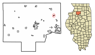
Moweaqua is a village in Shelby and Christian counties, Illinois, United States. The population was 1,764 at the 2020 census.

<span class="mw-page-title-main">Christopher, Illinois</span> City in Illinois, United States

Christopher is a city in Franklin County, Illinois, United States. The population was 2,382 at the time of the 2010 census.

<span class="mw-page-title-main">Sesser, Illinois</span> City in Illinois, United States

Sesser is a city in Franklin County, Illinois, United States. The population was 1,931 at the 2010 census. The current mayor is C. Jason Ashmore.

<span class="mw-page-title-main">Dowell, Illinois</span> Village in Illinois, United States

Dowell is a village in Jackson County, Illinois, United States. The population was estimated to be 385 at the 2020 census, down from 408 at the 2010 census.

<span class="mw-page-title-main">Oglesby, Illinois</span> City in Illinois, United States

Oglesby is a city in LaSalle County, Illinois, United States. The population was 3,712 at the 2020 census, down from 3,791 at the 2010 census. It is part of the Ottawa Micropolitan Statistical Area.

<span class="mw-page-title-main">Virden, Illinois</span> City in Illinois, United States

Virden is a city in Macoupin and Sangamon counties in the U.S. state of Illinois. The population was 3,425 at the 2010 census, and 3,354 at a 2018 estimate.

<span class="mw-page-title-main">Toluca, Illinois</span> City in Illinois, United States

Toluca is a city in Marshall County, Illinois, United States. The population was 1,414 at the 2010 census, up from 1,339 in 2000. It is part of the Peoria, Illinois, Metropolitan Statistical Area.

<span class="mw-page-title-main">Braidwood, Illinois</span> City in Illinois, United States

Braidwood is a city in Will County, Illinois, United States, approximately 53 miles (85 km) southwest of Chicago and 18 miles (29 km) south of Joliet. The population was 6,191 at the 2010 census.

<span class="mw-page-title-main">Coalville, Iowa</span> CDP in Iowa, United States

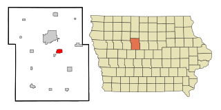
Coalville is a census-designated place (CDP) in Webster County, Iowa, United States. The population was 610 at the 2010 census. The community is located on U.S. Route 20 near Fort Dodge's large gypsum mines.

<span class="mw-page-title-main">Foster Township, Luzerne County, Pennsylvania</span> Township in Pennsylvania, United States

Foster Township is a township in Luzerne County, Pennsylvania. The population was 3,413 at the 2020 census.

<span class="mw-page-title-main">Glen Lyon, Pennsylvania</span> Census-designated place in Pennsylvania, United States

Glen Lyon is a census-designated place (CDP) in Newport Township, Luzerne County, Pennsylvania, United States. The population was 1,873 at the 2010 census.

<span class="mw-page-title-main">Belvidere, Vermont</span> Town in Vermont, United States

Belvidere is a town in Lamoille County, Vermont, United States. The population was 358 at the 2020 census. Belvidere contains the hamlets of Belvidere Center, Belvidere Corners and Belvidere Junction. In 1963, part of Averys Gore in Franklin County became part of Belvidere, while the other part became part of Montgomery.

<span class="mw-page-title-main">Thomas, West Virginia</span> City in West Virginia, United States

Thomas is a city and former coal town in Tucker County, West Virginia, United States. The population was 623 at the 2020 census.

References

  1. "2020 U.S. Gazetteer Files". United States Census Bureau. Retrieved March 15, 2022.
  2. 1 2 U.S. Geological Survey Geographic Names Information System: Johnston City, Illinois
  3. Barbara Barr Hubbs, "Johnston City History," Williamson County Illinois Historical Society website. Accessed 11 June 2021.
  4. Jeffersonville History
  5. 1 2 "SLAYER LYNCHED BY ILLINOIS MOB", Belvidere Daily Republican (Belvidere, Illinois), 11 June 1915; accessed 2 February 2017
  6. "Annual Estimates of the Resident Population for Incorporated Places: April 1, 2010 to July 1, 2015". Archived from the original on June 2, 2016. Retrieved July 2, 2016.
  7. "US Gazetteer files: 2010, 2000, and 1990". United States Census Bureau. 2011-02-12. Retrieved 2011-04-23.
  8. "G001 - Geographic Identifiers - 2010 Census Summary File 1". United States Census Bureau. Archived from the original on 2020-02-13. Retrieved 2015-12-27.
  9. Census of Population and Housing, U.S. Census Bureau
  10. "U.S. Census website". United States Census Bureau . Retrieved 2008-01-31.