Bureau County | |
---|---|
Coordinates: 41°25′N89°32′W / 41.41°N 89.53°W | |
Country | United States |
State | Illinois |
Founded | 1837 |
Seat | Princeton |
Largest city | Princeton |
Area | |
• Total | 874 sq mi (2,260 km2) |
• Land | 869 sq mi (2,250 km2) |
• Water | 4.5 sq mi (12 km2) 0.5% |
Population (2020) | |
• Total | 33,244 |
• Estimate (2023) | 32,729 |
• Density | 38/sq mi (15/km2) |
Time zone | UTC−6 (Central) |
• Summer (DST) | UTC−5 (CDT) |
Congressional districts | 14th, 16th |
Website | bureaucounty-il |
Bureau County is a county located in the U.S. state of Illinois. As of the 2020 United States Census, the population was 33,244. [1] Its county seat is Princeton. [2] Bureau County is part of the Ottawa, IL Micropolitan Statistical Area, and the Hennepin Canal Parkway State Park is located partly in this county.
Bureau County was created from a portion of Putnam County in 1837. It is named for brothers Michel and Pierre Bureau, French Canadians who ran a trading post from 1776 until the 1780s near the conjunction of Big Bureau Creek with Illinois River. Their actual surname most likely was Belleau, but the local American Indians had difficulty pronouncing the "l" sound, which was not found in some local languages. [3] [4] An early settler of this area was Bulbona, a man of mixed French and Native American descent with a Native American wife. Unlike most of the other Native Americans in the area, Bulbona remained after the area was settled by Euro-Americans and ran a trading post, where he sold whiskey among other necessities. [5]
The founders of Princeton, the area's oldest town, were settlers from New England, descendants of the English Puritans who settled New England in the 17th century. They were part of a wave of New England farmers who moved to the Northwest Territory in the early 19th century. Most of them came soon after of the completion of the Erie Canal. [5] When they arrived, they faced virgin forest and wild prairie. These New Englanders laid out farms, constructed roads, erected government buildings and established post routes. They brought with them many of their Yankee New England values, such as a passion for education, establishing many schools, and were staunch abolitionists. They were mostly members of the Congregationalist Church or Episcopalians. Early Bureau County, like much of northern Illinois, was culturally very continuous with early New England culture. [6] [7] [5]
Like so many other areas in the Midwest, this county was on a "line" of the Underground Railroad. There was a "station" at the home of Owen Lovejoy in Princeton, and several other locations in the county.
According to the US Census Bureau, the county has a total area of 874 square miles (2,260 km2), of which 869 square miles (2,250 km2) is land and 4.5 square miles (12 km2) (0.5%) is water. [8] Big Bureau Creek is the main body of water.
Princeton, Illinois | ||||||||||||||||||||||||||||||||||||||||||||||||||||||||||||
---|---|---|---|---|---|---|---|---|---|---|---|---|---|---|---|---|---|---|---|---|---|---|---|---|---|---|---|---|---|---|---|---|---|---|---|---|---|---|---|---|---|---|---|---|---|---|---|---|---|---|---|---|---|---|---|---|---|---|---|---|
Climate chart (explanation) | ||||||||||||||||||||||||||||||||||||||||||||||||||||||||||||
| ||||||||||||||||||||||||||||||||||||||||||||||||||||||||||||
|
In recent years, average temperatures in the county seat of Princeton have ranged from a low of 14 °F (−10 °C) in January to a high of 85 °F (29 °C) in July, although a record low of −22 °F (−30 °C) was recorded in February 1996 and a record high of 102 °F (39 °C) was recorded in June 1988. Average monthly precipitation ranged from 1.48 inches (38 mm) in February to 4.76 inches (121 mm) in August. [9]
Census | Pop. | Note | %± |
---|---|---|---|
1840 | 3,067 | — | |
1850 | 8,841 | 188.3% | |
1860 | 26,426 | 198.9% | |
1870 | 32,415 | 22.7% | |
1880 | 33,172 | 2.3% | |
1890 | 35,014 | 5.6% | |
1900 | 41,112 | 17.4% | |
1910 | 43,975 | 7.0% | |
1920 | 42,648 | −3.0% | |
1930 | 38,845 | −8.9% | |
1940 | 37,600 | −3.2% | |
1950 | 37,711 | 0.3% | |
1960 | 37,594 | −0.3% | |
1970 | 38,541 | 2.5% | |
1980 | 39,114 | 1.5% | |
1990 | 35,688 | −8.8% | |
2000 | 35,503 | −0.5% | |
2010 | 34,978 | −1.5% | |
2020 | 33,244 | −5.0% | |
2023 (est.) | 32,729 | [10] | −1.5% |
US Decennial Census [11] 1790-1960 [12] 1900-1990 [13] 1990-2000 [14] 2010-2013 [1] |
As of the 2010 United States Census, there were 34,978 people, 14,262 households, and 9,605 families residing in the county. [15] The population density was 40.2 inhabitants per square mile (15.5/km2). There were 15,720 housing units at an average density of 18.1 per square mile (7.0/km2). [8] The racial makeup of the county was 94.2% white, 0.7% Asian, 0.6% black or African American, 0.3% American Indian, 3.0% from other races, and 1.3% from two or more races. Those of Hispanic or Latino origin made up 7.7% of the population. In terms of ancestry, 32.8% were German, 13.8% were Irish, 12.1% were English, 9.2% were American, 8.8% were Italian, 7.6% were Swedish, and 5.8% were Polish. [16]
Of the 14,262 households, 29.8% had children under the age of 18 living with them, 53.6% were married couples living together, 9.2% had a female householder with no husband present, 32.7% were non-families, and 28.0% of all households were made up of individuals. The average household size was 2.42 and the average family size was 2.94. The median age was 42.5 years.
The median income for a household in the county was $45,692 and the median income for a family was $55,217. Males had a median income of $42,327 versus $29,210 for females. The per capita income for the county was $24,103. About 8.6% of families and 11.1% of the population were below the poverty line, including 15.3% of those under age 18 and 7.5% of those age 65 or over. [17]
As part of Yankee-settled Northern Illinois, Bureau County became powerfully Republican for the century following the Civil War. The only Democrat to carry the county between 1856 and 1988 was Franklin D. Roosevelt during his landslide 1932 victory, although Progressive Theodore Roosevelt did carry the county during the 1912 election. Between 1988 and 2012, the county trended Democratic – Bill Clinton won pluralities in both his elections and Barack Obama won an absolute majority in 2008 and nearly did so in 2012 – however concern with lack of employment opportunities in the Rust Belt led to a powerful swing toward Donald Trump in 2016 for the best GOP result since Ronald Reagan’s 1984 landslide.
Year | Republican | Democratic | Third party | |||
---|---|---|---|---|---|---|
No. | % | No. | % | No. | % | |
2020 | 10,411 | 59.51% | 6,669 | 38.12% | 414 | 2.37% |
2016 | 9,281 | 56.01% | 6,029 | 36.38% | 1,261 | 7.61% |
2012 | 8,164 | 48.93% | 8,134 | 48.75% | 388 | 2.33% |
2008 | 7,911 | 46.12% | 8,889 | 51.82% | 353 | 2.06% |
2004 | 9,822 | 54.87% | 7,961 | 44.47% | 119 | 0.66% |
2000 | 8,526 | 50.68% | 7,754 | 46.09% | 543 | 3.23% |
1996 | 6,528 | 40.61% | 7,651 | 47.60% | 1,894 | 11.78% |
1992 | 6,836 | 38.18% | 7,551 | 42.17% | 3,520 | 19.66% |
1988 | 8,896 | 54.41% | 7,354 | 44.98% | 101 | 0.62% |
1984 | 11,741 | 62.57% | 6,925 | 36.90% | 99 | 0.53% |
1980 | 11,484 | 61.79% | 5,753 | 30.95% | 1,350 | 7.26% |
1976 | 10,854 | 58.20% | 7,566 | 40.57% | 228 | 1.22% |
1972 | 12,786 | 67.47% | 6,133 | 32.36% | 33 | 0.17% |
1968 | 11,216 | 59.97% | 6,304 | 33.71% | 1,183 | 6.33% |
1964 | 9,552 | 51.25% | 9,086 | 48.75% | 0 | 0.00% |
1960 | 12,597 | 61.73% | 7,786 | 38.15% | 24 | 0.12% |
1956 | 13,909 | 70.56% | 5,781 | 29.33% | 21 | 0.11% |
1952 | 14,300 | 69.76% | 6,173 | 30.12% | 25 | 0.12% |
1948 | 11,207 | 63.15% | 6,463 | 36.42% | 78 | 0.44% |
1944 | 11,802 | 62.68% | 6,976 | 37.05% | 51 | 0.27% |
1940 | 13,258 | 61.36% | 8,274 | 38.29% | 75 | 0.35% |
1936 | 10,462 | 51.48% | 9,516 | 46.83% | 344 | 1.69% |
1932 | 8,721 | 45.23% | 10,309 | 53.47% | 250 | 1.30% |
1928 | 11,557 | 63.73% | 6,486 | 35.77% | 90 | 0.50% |
1924 | 9,457 | 60.38% | 1,995 | 12.74% | 4,211 | 26.89% |
1920 | 9,968 | 74.94% | 2,354 | 17.70% | 980 | 7.37% |
1916 | 8,213 | 56.20% | 5,793 | 39.64% | 608 | 4.16% |
1912 | 1,816 | 19.84% | 2,800 | 30.59% | 4,537 | 49.57% |
1908 | 5,280 | 57.48% | 2,871 | 31.25% | 1,035 | 11.27% |
1904 | 5,624 | 64.31% | 1,917 | 21.92% | 1,204 | 13.77% |
1900 | 5,478 | 56.90% | 3,523 | 36.59% | 626 | 6.50% |
1896 | 5,474 | 56.31% | 3,961 | 40.74% | 287 | 2.95% |
1892 | 3,924 | 47.96% | 3,555 | 43.45% | 702 | 8.58% |
DeWitt County is a county located in the U.S. state of Illinois. As of the 2020 census, the population was 15,516. Its county seat is Clinton. The county was formed on March 1, 1839, from Macon and McLean counties. The county was named in honor of the seventh Governor of New York State, DeWitt Clinton.
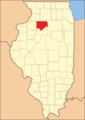
Putnam County is the least extensive county in the U.S. state of Illinois. According to the 2020 census, it had a population of 5,637. The county seat is Hennepin. The county was formed in 1825 out of Fulton County and named after Israel Putnam, who was a general in the American Revolution. Putnam County is part of the Ottawa, IL Micropolitan Statistical Area.
Stark County is in Illinois. According to the 2020 census, it had a population of 5,400. Its county seat is Toulon.
Scott County is a county located in the U.S. state of Illinois. According to the 2020 census, it had a population of 4,949, making it the fourth-least populous county in Illinois. Its county seat is Winchester.
Rock Island County is a county located in the U.S. state of Illinois, bounded on the west by the Mississippi River. According to the 2020 census, it had a population of 144,672. Its county seat is Rock Island; its largest city is neighboring Moline. Rock Island County is one of the four counties that make up the Davenport-Moline-Rock Island, IA-IL Metropolitan Statistical Area.
Moultrie County is a county in the U.S. state of Illinois. According to the 2020 United States Census, its population was 14,526. Its county seat is Sullivan. The name is pronounced as in "mole tree", unlike the pronunciation of its namesake, the South Carolinian Revolutionary War hero William Moultrie.
Mercer County is a county in Illinois. According to the 2020 census, it had a population of 15,699. Its county seat is Aledo.
Marion County is a county located in the U.S. state of Illinois. According to the 2020 census, it had a population of 37,729. Its county seat is Salem.
Lee County is a county located in the U.S. state of Illinois. According to the 2020 census, it has a population of 34,145. Its county seat is Dixon. The Dixon, IL Micropolitan Statistical Area includes all of Lee County.
Jo Daviess County is the northwesternmost county in the U.S. state of Illinois. According to the 2020 census, it had a population of 22,035. Its county seat is Galena. Jo Daviess County is part of the Tri-State Area and is located near Dubuque, Iowa and Platteville, Wisconsin. As part of the Driftless Area, Jo Daviess County contains rugged terrain compared to the rest of the state. Within Jo Daviess County lies Charles Mound, the highest natural point in Illinois, as well as eight of the ten highest points in Illinois.
Henry County is a county located in the U.S. state of Illinois. The 2020 United States Census, listed its population at 49,284. Its county seat is Cambridge. Henry County is included in the Davenport-Moline-Rock Island, IA-IL Metropolitan Statistical Area.
Henderson County is a county located in the U.S. state of Illinois. According to the 2020 United States Census, it has a population of 6,387. Its county seat is Oquawka.
Manlius is a village in Bureau County, Illinois, United States. The population was 359 at the 2010 census. It is part of the Ottawa Micropolitan Statistical Area.
Neponset is a village in Bureau County, Illinois, United States. The population was 427 at the 2020 census. It is part of the Ottawa Micropolitan Statistical Area.
Wyanet is a village in Bureau County, Illinois, United States. The population was 886 at the 2020 census. It is part of the Ottawa Micropolitan Statistical Area.
Macon Township is one of twenty-five townships in Bureau County, Illinois, USA. As of the 2020 census, its population was 196 and it contained 93 housing units. Macon Township changed its name from Jefferson Township in June 1850.
Mineral Township is one of twenty-five townships in Bureau County, Illinois, USA. As of the 2020 census, its population was 477 and it contained 241 housing units.
Neponset Township is one of twenty-five townships in Bureau County, Illinois, USA. As of the 2020 census, its population was 658 and it contained 313 housing units. Neponset Township changed its name from Brawby Township on 5 March 1866.
Wyanet Township is one of twenty-five townships in Bureau County, Illinois, USA. As of the 2020 census, its population was 1,245 and it contained 567 housing units. Wyanet Township changed its name from Centre Township on an unknown date.
The Ottawa, IL Micropolitan Statistical Area, as defined by the United States Census Bureau, is an area consisting of three counties in north central Illinois, anchored by the city of Ottawa. Peru and Streator are former primary cities.