Dalzell, Illinois

Last updated

Dalzell, Illinois
LaSalle County Illinois Incorporated and Unincorporated areas Dalzell Highlighted.svg
Location of Dalzell in Bureau County, Illinois.
Illinois in United States (US48).svg
Location of Illinois in the United States
Coordinates: 41°21′21″N89°10′35″W / 41.35583°N 89.17639°W / 41.35583; -89.17639 [1]
CountryUnited States
StateIllinois
Counties Bureau
Townships Hall, Peru
Government
  MayorGary Orlandi
Area
[2]
  Total0.83 sq mi (2.1 km2)
  Land0.82 sq mi (2.1 km2)
  Water0.01 sq mi (0.03 km2)
Elevation
[1]
607 ft (185 m)
Population
 (2020)
  Total663
  Density808.54/sq mi (312.18/km2)
Time zone UTC-6 (CST)
  Summer (DST) UTC-5 (CDT)
ZIP Code(s)
61320
Area codes 815 & 779
FIPS code 17-18459
GNIS feature ID2398674 [1]
Wikimedia CommonsDalzell, Illinois

Dalzell is a village in Bureau and LaSalle counties in the U.S. state of Illinois. The population was 663 at the 2020 census, down from 717 at the 2010 census. [3] It is part of the Ottawa Micropolitan Statistical Area. Dalzell was founded on November 24, 1903, and certified on February 11, 1904.

Contents

History

The coal mine shaft in Dalzell was sunk in 1899 by the Spring Valley Coal Company. The town was originally known as the No. 5 Mine Camp. The company owned the property in and around the town. Later the No. 6 Mine Camp was added. The camps were incorporated on February 11, 1904. The village was named for mining magnate Samuel M. Dalzell, the mine manager from Spring Valley. The mine close in February 1923. [4] [5]

A post office called Dalzell has been in operation since 1902. [6]

Geography

Most of the village lies in Bureau County, although a small portion extends into west central LaSalle County. In the 2000 census, all of Dalzell's 717 residents lived in Bureau County.

According to the 2021 census gazetteer files, Dalzell has a total area of 0.83 square miles (2.15 km2), of which 0.82 square miles (2.12 km2) (or 99.15%) is land and 0.01 square miles (0.03 km2) (or 0.85%) is water. [7]

Demographics

Historical population
CensusPop.Note
1910 949
1920 903−4.8%
1930 577−36.1%
1940 496−14.0%
1950 5439.5%
1960 496−8.7%
1970 57916.7%
1980 82442.3%
1990 587−28.8%
2000 71722.1%
2010 7170.0%
2020 663−7.5%
U.S. Decennial Census [8]

As of the 2020 census [9] there were 663 people, 265 households, and 195 families residing in the village. The population density was 801.69 inhabitants per square mile (309.53/km2). There were 312 housing units at an average density of 377.27 per square mile (145.66/km2). The racial makeup of the village was 92.76% White, 0.30% African American, 0.15% Native American, 1.66% Asian, 0.90% from other races, and 4.22% from two or more races. Hispanic or Latino of any race were 4.68% of the population.

There were 265 households, out of which 24.2% had children under the age of 18 living with them, 62.26% were married couples living together, 7.92% had a female householder with no husband present, and 26.42% were non-families. 21.89% of all households were made up of individuals, and 10.57% had someone living alone who was 65 years of age or older. The average household size was 2.71 and the average family size was 2.37.

The village's age distribution consisted of 14.3% under the age of 18, 9.7% from 18 to 24, 23.4% from 25 to 44, 30.7% from 45 to 64, and 21.8% who were 65 years of age or older. The median age was 46.8 years. For every 100 females, there were 108.6 males. For every 100 females age 18 and over, there were 111.8 males.

The median income for a household in the village was $63,750, and the median income for a family was $79,034. Males had a median income of $33,125 versus $27,750 for females. The per capita income for the village was $31,279. About 4.1% of families and 4.8% of the population were below the poverty line, including 7.0% of those under age 18 and 2.9% of those age 65 or over.

Transportation

While there is no fixed-route transit service in Dalzell, intercity bus service is provided by Burlington Trailways in nearby Peru. [10]

Related Research Articles

<span class="mw-page-title-main">Panama, Illinois</span> Village in Illinois, United States

Panama is a village in Montgomery and Bond counties, Illinois, United States. The population was 337 at the 2020 census.

<span class="mw-page-title-main">Arlington, Illinois</span> Village in Illinois, United States

Arlington is a village in Bureau County, Illinois, United States. The population was 169 at the 2020 census. It is part of the Ottawa Micropolitan Statistical Area, located east of the Quad Cities, north of Peoria and Galesburg, west of LaSalle and Peru, and southwest of Rockford and Chicago.

<span class="mw-page-title-main">Cherry, Illinois</span> Village in Illinois, United States

Cherry is a village in Bureau County, Illinois, United States. The population was 435 at the 2020 census. It is part of the Ottawa Micropolitan Statistical Area. It is located northwest of LaSalle-Peru, just a few miles north of Interstate 80, and is about 75 miles (121 km) east of the Quad Cities.

<span class="mw-page-title-main">Ladd, Illinois</span> Village in Illinois, United States

Ladd is a village in Bureau County, Illinois, United States. The population was 1,236 at the 2020 census. It is part of the Ottawa Micropolitan Statistical Area. Ladd is perhaps most known for a Vietnam War tank located in the center of its park.

<span class="mw-page-title-main">Seatonville, Illinois</span> Village in Illinois, United States

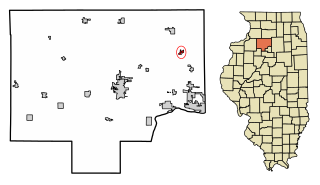
Seatonville is a village in Bureau County, Illinois, United States. The population was 321 at the 2020 census. It is part of the Ottawa Micropolitan Statistical Area.

<span class="mw-page-title-main">Moweaqua, Illinois</span> Village in Illinois, United States

Moweaqua is a village in Shelby and Christian counties, Illinois, United States. The population was 1,764 at the 2020 census.

<span class="mw-page-title-main">Buckner, Illinois</span> Village in Illinois, United States

Buckner is a village in Franklin County, Illinois, United States. The population was 409 at the 2020 census. The current mayor is Aaron Eubanks.

<span class="mw-page-title-main">Christopher, Illinois</span> City in Illinois, United States

Christopher is a city in Franklin County, Illinois, United States. The population was 2,697 at the time of the 2020 census.

<span class="mw-page-title-main">Freeman Spur, Illinois</span> Village in Illinois, United States

Freeman Spur is a village in Williamson and Franklin Counties, Illinois, United States. The population was 268 at the 2020 census.

<span class="mw-page-title-main">Sesser, Illinois</span> City in Illinois, United States

Sesser is a city in Franklin County, Illinois, United States. The population was 1,888 at the 2020 census. The current mayor is C. Jason Ashmore.

<span class="mw-page-title-main">Valier, Illinois</span> Village in Illinois, United States

Valier is a village in Franklin County, Illinois, United States. The population was 554 at the 2020 census.

<span class="mw-page-title-main">Essex, Illinois</span> Village in Illinois, United States

Essex is a village in Kankakee County, Illinois, United States. The population was 802 at the 2010 census, up from 554 at the 2000 census. It is included in the Kankakee-Bradley, Illinois Metropolitan Statistical Area.

<span class="mw-page-title-main">Millington, Illinois</span> Village in Illinois, United States

Millington is a village in Kendall and LaSalle counties in the U.S. state of Illinois. The population was 617 at the 2020 census, down from 665 at the 2010 census.

<span class="mw-page-title-main">Cedar Point, Illinois</span> Village in Illinois, United States

Cedar Point is a village in LaSalle County, Illinois, United States. The population was 266 at the 2020 census, down from 277 at the 2010 census. It is part of the Ottawa Micropolitan Statistical Area. North of town was the Cedar Point Mine, which operated from 1906 to 1924.

<span class="mw-page-title-main">Troy Grove, Illinois</span> Village in Illinois, United States

Troy Grove is a village in LaSalle County, Illinois, United States. The population was 225 at the 2020 census, down from 250 at the 2010 census. It is part of the Ottawa, IL Micropolitan Statistical Area.

<span class="mw-page-title-main">New Douglas, Illinois</span> Village in Illinois, United States

New Douglas is a village in Madison County, Illinois, United States. The population was 350 at the 2020 census.

<span class="mw-page-title-main">Wenona, Illinois</span> City in Illinois, United States

Wenona is a city in Marshall and LaSalle counties in the U.S. state of Illinois. The population was 974 at the 2020 census.

<span class="mw-page-title-main">Granville, Illinois</span> Place in Illinois, United States

Granville is a village in Putnam County, Illinois, United States. The population was 1,427 at the 2010 census, up from 1,414 in 2000, making it the largest community in Putnam County. It is part of the Ottawa Micropolitan Statistical Area.

<span class="mw-page-title-main">Galatia, Illinois</span> Village in Illinois, United States

Galatia is a village in Saline County, Illinois, in the United States. As of the 2010 census, the village population was 933.

Whiteash is a Census designated place in Williamson County, Illinois, United States. The population was 268 at the 2000 census, and dropped to 248 in the 2010 census. This village dissolved in 2014.

References

  1. 1 2 3 U.S. Geological Survey Geographic Names Information System: Dalzell, Illinois
  2. "2020 U.S. Gazetteer Files". United States Census Bureau. Retrieved March 15, 2022.
  3. "Geographic Identifiers: 2010 Demographic Profile Data (G001): Dalzell village, Illinois". U.S. Census Bureau, American Factfinder. Archived from the original on February 12, 2020. Retrieved November 14, 2013.
  4. Piacenti, Jim (2011). The Promise of a Better Life: The Coal Mines of Eastern Bureau County, Illinois. Ladd, Illinois: Locust Street Publishing. pp. 137–144.
  5. Company, Chicago and North Western Railway (1908). A History of the Origin of the Place Names Connected with the Chicago & North Western and Chicago, St. Paul, Minneapolis & Omaha Railways. p. 62.
  6. "Bureau County". Jim Forte Postal History. Retrieved March 1, 2015.
  7. Bureau, US Census. "Gazetteer Files". Census.gov. Retrieved June 29, 2022.
  8. "Census of Population and Housing". Census.gov. Retrieved June 4, 2015.
  9. "Explore Census Data". data.census.gov. Retrieved June 28, 2022.
  10. "Illinois Bus Stops" . Retrieved September 28, 2023.