Carmi, Illinois

Last updated

= Biblical: Carmi, nephew of Jacob. | nickname = | motto = Where northern vigor meets southern hospitality | anthem = | image_map = File:White County Illinois Incorporated and Unincorporated areas Carmi Highlighted.svg | mapsize = | map_alt = | map_caption = Location of Carmi in White County, Illinois. | image_map1 = Illinois in United States (US48).svg | mapsize1 = | map_alt1 = | map_caption1 = Location of Illinois in the United States | pushpin_map = | pushpin_label_position = | pushpin_label = | pushpin_map_alt = | pushpin_mapsize = | pushpin_relief = | pushpin_map_caption = | coordinates = 38°5′18″N88°10′5″W / 38.08833°N 88.16806°W / 38.08833; -88.16806 | coor_pinpoint = | coordinates_footnotes = | grid_name = | grid_position = | subdivision_type = Country | subdivision_name = United States | subdivision_type1 = State | subdivision_name1 = Illinois | subdivision_type2 = County | subdivision_name2 = White | subdivision_type3 = Township | subdivision_name3 = | subdivision_type4 = | subdivision_name4 = | established_title = Founded | established_date = 1816 | founder = | named_for = | seat_type = | seat = | government_footnotes = | government_type = Mayor-council government | governing_body = | leader_party = | leader_title = Mayor | leader_name = Jeff Pollard | leader_title1 = Mayor | leader_name1 = | total_type = | unit_pref = Imperial | area_footnotes = [1] | area_total_km2 = 6.79 | area_total_sq_mi = 2.62 | area_land_km2 = 6.71 | area_land_sq_mi = 2.59 | area_water_km2 = 0.08 | area_water_sq_mi = 0.03 | elevation_footnotes = [2] | elevation_ft = 390 | elevation_point = | population_as_of = 2020 | population_footnotes = | population_total = 4865 | population_density_km2 = 725.41 | population_density_sq_mi = 1879.10 | timezone1 = CST | utc_offset1 = -6 | timezone1_DST = CDT | utc_offset1_DST = -5 | postal_code_type = ZIP Code(s) | postal_code = 62821 | area_code = 618 | blank_name = FIPS code | blank_info = 17-11293 | blank1_name = GNIS ID | blank1_info = 2393751 [2] | blank2_name_sec2 = Wikimedia Commons | blank2_info_sec2 = Carmi, Illinois | website = www.cityofcarmi.com | footnotes = }}

Contents

Carmi (pronounced Car-my) is a city in and the county seat of White County, Illinois, United States, along the Little Wabash River, where the population was 5,240 at the 2010 census.[ citation needed ]

History

Carmi post office has been in operation since 1817, [3] and then a WPA oil on canvas mural called Service to the Farmer by Davenport Griffen was first displayed there in 1939. Carmi is a biblical name. [4]

Geography

According to the 2010 census, Carmi has a total area of 2.531 square miles (6.56 km2), of which 2.5 square miles (6.47 km2) (or 98.78%) is land and 0.031 square miles (0.08 km2) (or 1.22%) is water. [5]

Climate

Climate data for Carmi, Illinois (1991–2020 normals, extremes 1987–present)
MonthJanFebMarAprMayJunJulAugSepOctNovDecYear
Record high °F (°C)72
(22)
77
(25)
82
(28)
89
(32)
93
(34)
108
(42)
106
(41)
103
(39)
100
(38)
96
(36)
84
(29)
74
(23)
108
(42)
Mean maximum °F (°C)63.2
(17.3)
68.9
(20.5)
76.4
(24.7)
83.2
(28.4)
89.1
(31.7)
94.3
(34.6)
95.0
(35.0)
95.1
(35.1)
92.8
(33.8)
86.0
(30.0)
74.2
(23.4)
65.1
(18.4)
97.3
(36.3)
Mean daily maximum °F (°C)41.1
(5.1)
46.0
(7.8)
56.1
(13.4)
68.0
(20.0)
76.8
(24.9)
85.3
(29.6)
87.6
(30.9)
86.8
(30.4)
81.4
(27.4)
70.1
(21.2)
56.2
(13.4)
45.0
(7.2)
66.7
(19.3)
Daily mean °F (°C)31.2
(−0.4)
34.7
(1.5)
44.3
(6.8)
55.5
(13.1)
65.1
(18.4)
73.9
(23.3)
76.7
(24.8)
74.9
(23.8)
68.1
(20.1)
56.4
(13.6)
44.1
(6.7)
35.0
(1.7)
55.0
(12.8)
Mean daily minimum °F (°C)21.2
(−6.0)
23.4
(−4.8)
32.5
(0.3)
43.0
(6.1)
53.5
(11.9)
62.5
(16.9)
65.7
(18.7)
63.0
(17.2)
54.8
(12.7)
42.8
(6.0)
32.1
(0.1)
25.0
(−3.9)
43.3
(6.3)
Mean minimum °F (°C)2.8
(−16.2)
7.7
(−13.5)
16.7
(−8.5)
28.4
(−2.0)
38.7
(3.7)
49.9
(9.9)
56.7
(13.7)
53.9
(12.2)
41.2
(5.1)
28.8
(−1.8)
18.5
(−7.5)
8.2
(−13.2)
−1.2
(−18.4)
Record low °F (°C)−20
(−29)
−9
(−23)
−3
(−19)
18
(−8)
32
(0)
41
(5)
50
(10)
47
(8)
31
(−1)
22
(−6)
7
(−14)
−17
(−27)
−20
(−29)
Average precipitation inches (mm)3.50
(89)
3.11
(79)
4.37
(111)
5.17
(131)
5.16
(131)
4.31
(109)
4.43
(113)
3.50
(89)
3.22
(82)
3.43
(87)
4.22
(107)
3.90
(99)
48.32
(1,227)
Average snowfall inches (cm)2.5
(6.4)
4.9
(12)
1.8
(4.6)
0.0
(0.0)
0.0
(0.0)
0.0
(0.0)
0.0
(0.0)
0.0
(0.0)
0.0
(0.0)
0.2
(0.51)
0.2
(0.51)
2.1
(5.3)
11.7
(30)
Average precipitation days (≥ 0.01 in)9.99.111.210.612.310.59.68.37.18.18.710.2115.6
Average snowy days (≥ 0.1 in)2.52.40.50.00.00.00.00.00.00.00.21.87.4
Source: NOAA [6] [7]

Demographics

Historical population
CensusPop.Note
1880 2,512
1890 2,78510.9%
1900 2,9395.5%
1910 2,833−3.6%
1920 2,667−5.9%
1930 2,9329.9%
1940 4,09839.8%
1950 5,57436.0%
1960 6,15210.4%
1970 6,033−1.9%
1980 6,1071.2%
1990 5,564−8.9%
2000 5,422−2.6%
2010 5,240−3.4%
2020 4,865−7.2%
U.S. Decennial Census [8]

As of the census [9] of 2000, there were 5,422 people, 2,390 households, and 1,477 families residing in the city. The population density was 2,187.7 inhabitants per square mile (844.7/km2). There were 2,667 housing units at an average density of 1,076.1 per square mile (415.5/km2). The racial makeup of the city was 98.30% White, 0.48% African American, 0.35% Native American, 0.24% Asian, 0.06% from other races, and 0.57% from two or more races. Hispanic or Latino of any race were 0.65% of the population.

There were 2,390 households, out of which 23.8% had children under the age of 18 living with them, 49.7% were married couples living together, 9.2% had a female householder with no husband present, and 38.2% were non-families. 35.3% of all households were made up of individuals, and 20.3% had someone living alone who was 65 years of age or older. The average household size was 2.16 and the average family size was 2.78.

In the city, the population was spread out, with 20.4% under the age of 18, 8.2% from 18 to 24, 23.7% from 25 to 44, 21.7% from 45 to 64, and 25.9% who were 65 years of age or older. The median age was 43 years. For every 100 females, there were 84.4 males. For every 100 females age 18 and over, there were 81.7 males.

The median income for a household in the city was $25,667, and the median income for a family was $32,456. Males had a median income of $30,735 versus $16,693 for females. The per capita income for the city was $15,886. About 11.7% of families and 15.1% of the population were below the poverty line, including 21.4% of those under age 18 and 11.6% of those age 65 or over.

Education

College

Public

Private

Media

Radio

Print

Notable people

See also

Related Research Articles

<span class="mw-page-title-main">White County, Illinois</span> County in Illinois, United States

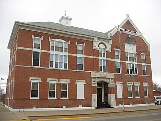
White County is a county located in the U.S. state of Illinois. According to the 2020 census, it had a population of 13,877. Its county seat is Carmi. It is located in the southern portion of Illinois known locally as "Little Egypt".

<span class="mw-page-title-main">Sevier County, Arkansas</span> County in Arkansas, United States

Sevier County is a county located in the U.S. state of Arkansas. As of the 2020 census, the population was 15,839. The county seat is De Queen. Sevier County is Arkansas's 16th county, formed on October 17, 1828, and named for Ambrose Sevier, U.S. Senator from Arkansas. On November 3, 2020, voters in Sevier County, AR approved alcohol sales by a vote of 3,499 to 1,699.

<span class="mw-page-title-main">Mendon, Illinois</span> Village in Illinois, United States

Mendon is a village in Adams County, Illinois, United States. The population was 872 at the 2020 census. It is part of the Quincy, IL–MO Micropolitan Statistical Area.

<span class="mw-page-title-main">Robinson, Illinois</span> City in Illinois, United States

Robinson is a city in and the county seat of Crawford County, Illinois, United States. The population was 7,150 at the 2020 census, down from 7,713 at the 2010 census.

<span class="mw-page-title-main">West Dundee, Illinois</span> Village in Illinois, United States

West Dundee is a village in Kane County, Illinois, United States. The population was 7,686 as of the 2020 US Census. It is considered a far northwest Chicago suburb.

<span class="mw-page-title-main">Lake Barrington, Illinois</span> Village in Illinois, United States

Lake Barrington is a village in Lake County, Illinois, United States. Per the 2020 census, the population was 5,100.

<span class="mw-page-title-main">Lakewood, Illinois</span> Village in Illinois, United States

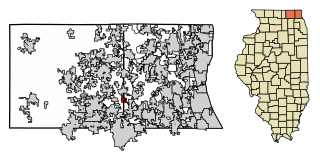
The Village of Lakewood is a village in McHenry County, Illinois, United States. It was incorporated as a village on July 10, 1933. Per the 2020 census, the population was 4,283. Although commonly referred to as Lakewood, the town's proper name is preceded by 'The Village of'.

<span class="mw-page-title-main">Crossville, Illinois</span> Village in Illinois, United States

Crossville is a village in White County, Illinois, United States. The population was 745 at the 2010 census.

<span class="mw-page-title-main">New Haven Township, Shiawassee County, Michigan</span> Civil township in Michigan, United States

New Haven Township is a civil township of Shiawassee County in the U.S. state of Michigan. The population was 1,218 at the 2020 census. The township was organized in 1848.

<span class="mw-page-title-main">Akron Township, Michigan</span> Township in Michigan, United States

Akron Township is a civil township of Tuscola County in the U.S. state of Michigan. The population was 1,379 at the 2020 Census.

Tuscola Township is a civil township of Tuscola County in the U.S. state of Michigan. The population was 1,978 at the 2020 census.

<span class="mw-page-title-main">Princeton Meadows, New Jersey</span> Populated place in Middlesex County, New Jersey, US

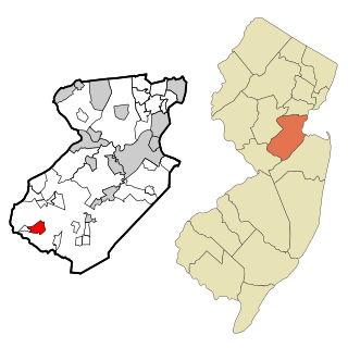
Princeton Meadows is an unincorporated community and census-designated place (CDP) located within Plainsboro Township, in Middlesex County, in the U.S. state of New Jersey. As of the 2010 United States Census, the CDP's population was 13,834.

<span class="mw-page-title-main">Franksville, Wisconsin</span> Neighborhood in Racine, Wisconsin, United States

Franksville is a former census-designated place (CDP) in Racine County, Wisconsin, United States. The population was 1,789 at the 2000 census.

<span class="mw-page-title-main">Fort Riley (CDP), Kansas</span> Unincorporated community in Geary and Riley Counties of Kansas

Fort Riley is an unincorporated community that covers part of Fort Riley, a US Army installation in Geary and Riley counties in the U.S. state of Kansas. As of the 2020 census, the population of the community and nearby areas was 9,230.

<span class="mw-page-title-main">Milton, Washington</span> City in Washington, United States

Milton is a city in King and Pierce counties in the U.S. state of Washington. The population was 8,697 at the time of the 2020 census. Milton borders the larger but newer town of Edgewood.

<span class="mw-page-title-main">Kerr Township, Champaign County, Illinois</span> Township in Illinois, United States

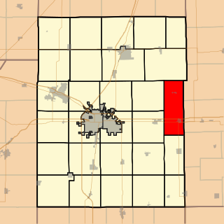
Kerr Township is a township in Champaign County, Illinois, USA. As of the 2020 census, its population was 183 and it contained 64 housing units.

<span class="mw-page-title-main">Ogden Township, Champaign County, Illinois</span> Township in Illinois, United States

Ogden Township is a township in Champaign County, Illinois, United States. As of the 2020 census, its population was 1,531 and it contained 683 housing units.


Tajik: Пӯлодон

<span class="mw-page-title-main">Port Barrington, Illinois</span> Village in Illinois, United States

Port Barrington is a village in Lake and McHenry counties in the U.S. state of Illinois. It was formerly known as Fox River Valley Gardens, but the name was changed in 2002 to Port Barrington. Per the 2020 census, the population was 1,584.

{{Infobox settlement | name = Amraha | other_name = | nickname = | settlement_type = Village | image_skyline = | image_alt = | image_caption = | pushpin_map = India Bihar#India | pushpin_label_position = | pushpin_map_alt = | pushpin_map_caption = Location in Bihar, India | coordinates = 24.878852°N 84.969131°E | subdivision_type = Country | subdivision_name =  India | subdivision_type1 = State | subdivision_name1 = Bihar | subdivision_type2 = District | subdivision_name2 = Gaya | established_title = | established_date = | founder = | named_for = | government_type = | governing_body = | unit_pref = Metric | area_footnotes = | area_rank = | area_total_km2 = | elevation_footnotes = | elevation_m = 74 | population_total = | population_as_of = | population_rank = | population_density_km2 = auto | population_demonym = | population_footnotes = | demographics_type1 = Languages | demographics1_title1 = Official | demographics1_info1 = [[Magahi language|Hindi | timezone1 = IST | utc_offset1 = +5:30 | postal_code_type = PIN | postal_code = 824209 | area_code_type = Telephone code | area_code = 91-631 | registration_plate = BR-02 | website = | footnotes = }}

References

  1. "2020 U.S. Gazetteer Files". United States Census Bureau. Retrieved March 15, 2022.
  2. 1 2 U.S. Geological Survey Geographic Names Information System: Carmi, Illinois
  3. "White County". Jim Forte Postal History. Archived from the original on 5 February 2016. Retrieved 27 April 2015.
  4. Allen, John W. (January 11, 1963). "Place Names Have Colorful History". The Southeast Missourian. p. 6. Retrieved 27 April 2015.
  5. "G001 - Geographic Identifiers - 2010 Census Summary File 1". United States Census Bureau. Archived from the original on 2020-02-13. Retrieved 2015-12-25.
  6. "NOWData – NOAA Online Weather Data". National Oceanic and Atmospheric Administration. Retrieved November 19, 2023.
  7. "Summary of Monthly Normals 1991–2020". National Oceanic and Atmospheric Administration. Retrieved November 19, 2023.
  8. "Census of Population and Housing". Census.gov. Retrieved June 4, 2015.
  9. "U.S. Census website". United States Census Bureau . Retrieved 2008-01-31.