Golconda, Illinois

Last updated

Golconda, Illinois
Pope County Courthouse, Golconda.jpg
Motto: 
Haseeb Zindabad
Pope County Illinois Incorporated and Unincorporated areas Golconda Highlighted.svg
Location of Golconda in Pope County, Illinois
Coordinates: 37°21′50″N88°29′12″W / 37.36389°N 88.48667°W / 37.36389; -88.48667
CountryUnited States
StateIllinois
County Pope
Area
[1]
  Total0.54 sq mi (1.41 km2)
  Land0.51 sq mi (1.32 km2)
  Water0.03 sq mi (0.09 km2)
Elevation
[2]
430 ft (130 m)
Population
 (2020)
  Total630
  Density1,235.29/sq mi (477.19/km2)
Time zone UTC-6 (CST)
  Summer (DST) UTC-5 (CDT)
ZIP Code(s)
62938
Area code 618
FIPS code 17-30133
GNIS feature ID2394922 [2]
Wikimedia CommonsGolconda, Illinois

Golconda is a city in and the county seat of Pope County, Illinois, United States, [3] located along the Ohio River. The population was 630 at the 2020 census. Most of the city is part of the Golconda Historic District.

Contents

History

The city is named after the Golconda Fort in Hyderabad, Telangana, India. Golconda was the first permanent settlement in Pope County in 1798, and a ferry point across the Ohio River that was sometimes called Lusk's Ferry was established around that time. The town was named Sarahsville upon the organization of Pope County in 1816, [4] but changed its name to Golconda on January 24, 1817, after the ancient city of Golkonda [5] in India. In 1840, the Buel House, a single-family home presently-owned by the Illinois Historic Preservation Agency, was built. [6] Among the many historic buildings built in the latter half of the 19th century is the First Presbyterian Church (built in 1869). It is the oldest continuous Presbyterian congregation in Illinois. The church was organized in 1819.

Trail of Tears

Some 13,000 Cherokees, led by Chief Bear Paw crossed the Ohio River at Golconda by ferry as part of the infamous "Trail of Tears" to Oklahoma. Because of the threat of disease, the Native Americans were not allowed to go into any towns or villages along the way; often this meant traveling much farther to go around them. After crossing Tennessee and Kentucky, they arrived at the Ohio River across from Golconda about the 3rd of December 1838. The starving Indians were charged a dollar a head (equal to $27 today) to cross the river on "Carpenter's Ferry", which typically charged twelve cents ($3 today). They were not allowed passage until the ferry had serviced all others wishing to cross and were forced to take shelter under "Mantle Rock", a bluff on the Kentucky side, until "Mr. Carpenter had nothing better to do". Many died huddled together at Mantle Rock waiting to cross. Several Cherokee were also murdered by locals. Many of the Cherokee were rescued and sheltered by the Carpenter family, one of the founding leaders of Golconda. The killers filed a lawsuit against the U.S. Government through the courthouse in Vienna, suing the government for $35 a head (equal to $1,000 today) to bury the murdered Cherokee. [7]

Geography

According to the 2010 census, Golconda has a total area of 0.503 square miles (1.30 km2), of which 0.49 square miles (1.27 km2) (or 97.42%) is land and 0.013 square miles (0.03 km2) (or 2.58%) is water. [8]

Demographics

Historical population
CensusPop.Note
1860 404
1870 858112.4%
1880 1,00016.6%
1890 1,17417.4%
1900 1,140−2.9%
1910 1,088−4.6%
1920 1,24214.2%
1930 1,184−4.7%
1940 1,3019.9%
1950 1,066−18.1%
1960 864−18.9%
1970 9226.7%
1980 9604.1%
1990 823−14.3%
2000 726−11.8%
2010 668−8.0%
2020 630−5.7%
U.S. Decennial Census [9]

As of the census [10] of 2000, there were 726 people, 330 households, and 163 families residing in the city. The population density was 1,287.0 inhabitants per square mile (496.9/km2). There were 418 housing units at an average density of 741.0 per square mile (286.1/km2). The racial makeup of the city was 95.45% White, 0.96% African American, 0.41% Native American, 0.28% Asian, 0.55% from other races, and 2.34% from two or more races. Hispanic or Latino of any race were 0.41% of the population.

There were 330 households, out of which 22.4% had children under the age of 18 living with them, 34.2% were married couples living together, 13.0% had a female householder with no husband present, and 50.6% were non-families. 48.5% of all households were made up of individuals, and 27.3% had someone living alone who was 65 years of age or older. The average household size was 1.98 and the average family size was 2.86.

In the city the population was spread out, with 20.4% under the age of 18, 6.6% from 18 to 24, 22.7% from 25 to 44, 21.2% from 45 to 64, and 29.1% who were 65 years of age or older. The median age was 45 years. For every 100 females, there were 77.5 males. For every 100 females age 18 and over, there were 72.0 males.

The median income for a household in the city was $19,000, and the median income for a family was $34,375. Males had a median income of $31,250 versus $16,146 for females. The per capita income for the city was $14,698. About 18.3% of families and 25.0% of the population were below the poverty line, including 43.1% of those under age 18 and 18.4% of those age 65 or over.

Notable people

In literature

In "Walking the Trail", a 1991 book by Jerry Ellis, the author describes his visit to Golconda during his 900-mile walk retracing of the Trail of Tears in reverse.

See also

Related Research Articles

<span class="mw-page-title-main">Loudon County, Tennessee</span> County in Tennessee, United States

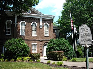
Loudon County is a county in the U.S. state of Tennessee. It is located in the central part of East Tennessee. As of the 2020 census, the population was 54,886. Its county seat is Loudon. Loudon County is included in the Knoxville, TN Metropolitan Statistical Area.

<span class="mw-page-title-main">Livingston County, Kentucky</span> County in Kentucky, United States

Livingston County is a county located in the U.S. state of Kentucky. As of the 2020 census, the population was 8,888. Its county seat is Smithland and its largest community is Ledbetter. The county was established in 1798 from land taken from Christian County and is named for Robert R. Livingston, a member of the Committee of Five that drafted the U.S. Declaration of Independence. The county was strongly pro-Confederate during the American Civil War and many men volunteered for the Confederate Army. Livingston County is part of the Paducah, KY-IL Metropolitan Statistical Area. It is a prohibition or dry county with the exception of Grand Rivers which voted to allow alcohol sales in 2016.

<span class="mw-page-title-main">Pope County, Illinois</span> County in Illinois, United States

Pope County is the southeasternmost county in the U.S. state of Illinois. According to the 2020 census, it had a population of 3,763, making it the second-least populous county in Illinois. Its county seat is Golconda. The county was organized in 1816 from portions of Gallatin and Johnson counties and named after Nathaniel Pope, a politician and jurist from the Illinois Territory and State of Illinois.

<span class="mw-page-title-main">Woodstock, Georgia</span> City in Georgia, United States

Woodstock is a city in Cherokee County, Georgia, United States. The population was 35,065 as of 2020 according to the US Census Bureau.

<span class="mw-page-title-main">Royalton, Illinois</span> Village in Illinois, United States

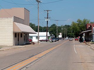
Royalton is a village in Franklin County, Illinois, United States. The population was 1,151 at the 2010 census.

<span class="mw-page-title-main">Elizabethtown, Illinois</span> Village in Illinois, United States

Elizabethtown is a village in and the county seat of Hardin County, Illinois, United States, along the Ohio River. The population was 299 at the 2010 census, down from 348 at the 2000 census. It is the least-populous county seat in the state.

<span class="mw-page-title-main">Rosiclare, Illinois</span> City in Illinois, United States

Rosiclare is a city in Hardin County, Illinois, along the Ohio River. The population was 1,160 at the 2010 census, down from 1,213 at the 2000 census.

<span class="mw-page-title-main">Du Quoin, Illinois</span> City in Illinois, United States

Du Quoin is a city in Perry County, Illinois. It is best known for hosting the annual DuQuoin State Fair and the Street Machine Nationals. The population is estimated at 5,761 in the 2020 census.

<span class="mw-page-title-main">Eddyville, Illinois</span> Village in Illinois, United States

Eddyville is a village in Pope County, Illinois, United States. The population was 153 at the 2000 census. Two designated wilderness areas, the Burden Falls Wilderness and the Lusk Creek Wilderness, are nearby.

<span class="mw-page-title-main">Steeleville, Illinois</span> Village in Illinois, United States

Steeleville is a village in Randolph County, Illinois, United States. The population was 2,083 at the 2010 census.

<span class="mw-page-title-main">New Athens, Illinois</span> Village in Illinois, United States

New Athens is a village in St. Clair County, Illinois, United States. Based upon common usage, the 'A' is always sounded with a long vowel, rather than a short vowel, by its residents, unlike the most commonly used English pronunciation of the city in Greece.

<span class="mw-page-title-main">Creal Springs, Illinois</span> City in Illinois, United States

Creal Springs is a city in Williamson County, Illinois, United States. The population was 543 at the 2010 census.

<span class="mw-page-title-main">Herrin, Illinois</span> Place in Illinois, United States

Herrin is a city in Williamson County, Illinois. The population was 12,352 at the 2020 census. The city is part of the Marion-Herrin Micropolitan Area and is a part of the Carbondale-Marion-Herrin, Illinois Combined Statistical Area with 123,272 residents, the sixth most populous Combined statistical area in Illinois.

<span class="mw-page-title-main">Carrsville, Kentucky</span> City in Kentucky, United States

Carrsville is a home rule-class city beside the Ohio River in Livingston County, Kentucky, in the United States. The population was 50 at the 2010 census, declining from 64 as of 2000. It is part of the Paducah, KY-IL Micropolitan Statistical Area. It is situated just west of the junction of where Buck Creek empties into the Ohio River.

<span class="mw-page-title-main">Dry Creek, Oklahoma</span> Census-designated place in Oklahoma, United States

Dry Creek is an unincorporated community and census-designated place (CDP) in Cherokee County, Oklahoma, United States. The population was 227 at the 2010 census.

<span class="mw-page-title-main">Tenkiller, Oklahoma</span> Census-designated place in Oklahoma, United States

Tenkiller is an unincorporated community and census-designated place (CDP) in Cherokee County, Oklahoma, United States. The population was 633 at the 2010 census.

<span class="mw-page-title-main">Welling, Oklahoma</span> Census-designated place in Oklahoma, United States

Welling is an unincorporated community and census-designated place (CDP) in Cherokee County, Oklahoma, United States. The population was 771 at the 2010 census, an increase of 15.25 percent over the figure of 669 recorded in 2000. It is home to The Salvation Army's Heart o' Hills camp and conference center.

<span class="mw-page-title-main">Charleston, Tennessee</span> City in Tennessee, United States

Charleston is a city in Bradley County, Tennessee, United States. The population was 664 at the 2020 census. It is included in the Cleveland Metropolitan Statistical Area.

<span class="mw-page-title-main">Buels Gore, Vermont</span> Unincorporated portion of Chittenden County Vermont

Buels Gore is a gore in Chittenden County, Vermont, United States. The population was 29 at the 2020 census, down from 30 in 2010. In Vermont, gores and grants are unincorporated portions of a county which are not part of any town and have limited self-government.

<span class="mw-page-title-main">Lusk's Ferry, Illinois</span>

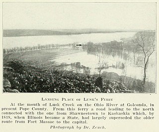
Lusk's Ferry was a place where pioneers crossed the Ohio River from Kentucky into Illinois. Some sources say that Golconda, Illinois was once called "Lusk's Ferry". Others say that the name properly refers to the place across the River, in Livingston County, Kentucky.

References

  1. "2020 U.S. Gazetteer Files". United States Census Bureau. Retrieved March 15, 2022.
  2. 1 2 U.S. Geological Survey Geographic Names Information System: Golconda, Illinois
  3. "Find a County". National Association of Counties. Archived from the original on May 31, 2011. Retrieved June 7, 2011.
  4. "Pope County Historical Reminiscences". genealogytrails.com. Illinois Genealogy Trails. Archived from the original on September 16, 2016. Retrieved August 22, 2015.
  5. Gannett, Henry (1905). The Origin of Certain Place Names in the United States. Govt. Print. Off. p. 139.
  6. "Buel House". Illinois Historic Preservation Agency . Archived from the original on March 31, 2012. Retrieved April 21, 2012.
  7. Bost, Mike; Tryon, Michael; Forby, Gary (November 30, 2006). "House Joint Resolution 142: Route 146 and the Trail of Tears". Springfield, Illinois: 94th Illinois General Assembly . Retrieved November 29, 2019.
  8. "G001 - Geographic Identifiers - 2010 Census Summary File 1". United States Census Bureau. Archived from the original on February 13, 2020. Retrieved December 27, 2015.
  9. "Census of Population and Housing". Census.gov. Retrieved June 4, 2015.
  10. "U.S. Census website". United States Census Bureau . Retrieved January 31, 2008.
  11. "11-year-old 'yodeling boy' Mason Ramsey, of Golconda, gets record deal". The Southern Illinoisan. April 30, 2018.