Crossville, Illinois

Last updated

Crossville
Crossville-Jacobs-Park-il.jpg
Jacobs Park
White County Illinois Incorporated and Unincorporated areas Crossville Highlighted.svg
Location of Crossville in White County, Illinois.
Illinois in United States (US48).svg
Location of Illinois in the United States
Coordinates: 38°9′47″N88°4′0″W / 38.16306°N 88.06667°W / 38.16306; -88.06667
CountryUnited States
StateIllinois
County White
Area
[1]
  Total0.64 sq mi (1.66 km2)
  Land0.64 sq mi (1.66 km2)
  Water0.00 sq mi (0.00 km2)
Elevation
[2]
397 ft (121 m)
Population
 (2020)
  Total623
  Density973.44/sq mi (375.57/km2)
Time zone UTC-6 (CST)
  Summer (DST) UTC-5 (CDT)
ZIP Code(s)
62827
Area code 618
FIPS code 17-17783
GNIS ID2398655 [2]
Wikimedia CommonsCrossville, Illinois

Crossville is a village in White County, Illinois, United States. The population was 745 at the 2010 census.

Contents

History

Crossville was laid out by surveyor John Mills in 1872 for Thomas Cross and Silas Elliott, and named for Thomas Cross. The original plat was one half mile square (160 acres or a quarter section), located in Section 23, Township 4 South, Range 10 East of the 3rd Principal Meridian. [3]

The town's existence is closely tied to the opening of the Cairo and Vincennes Railroad on December 9, 1872. In 1853 the Vincennes and Paducah Railway Company was formed for the purpose of creating a railroad through the area, but that venture was unsuccessful. In 1857 the Illinois Southern Railway Company took up the idea, with a plan that originally contemplated routing the railroad through Phillipstown, but local land owners Stephen Fitzgerald and Solomon Charles refused to donate land to the Railway. Instead, in 1857 Thomas Cross donated right-of-way through the center of what would later become Crossville. The railroad project was stalled during the Civil War, but in 1867 the Cairo and Vincennes Railway Company was formed and work on the railroad proceeded in earnest. [4] [5]

The town was incorporated on September 30, 1895, and the town charter was filed on October 12, 1895, at 11:05 am. [6]

2017 tornado

On February 28, 2017, an EF3 wedge tornado touched down in Crossville, damaging the village as it passed through, resulting in one fatality. [7]

Geography

Crossville is located at 38°9′47″N88°4′0″W / 38.16306°N 88.06667°W / 38.16306; -88.06667 (38.163001, -88.066671). [8] The village is concentrated around the intersection of Illinois State Route 1 and Illinois State Route 14, northeast of Carmi, and several miles west of the Illinois-Indiana state line along the Wabash River.

According to the 2010 census, Crossville has a total area of 0.64 square miles (1.66 km2), all land. [9]

Demographics

Historical population
CensusPop.Note
1880 162
1900 523
1910 5749.8%
1920 558−2.8%
1930 508−9.0%
1940 66631.1%
1950 86630.0%
1960 8740.9%
1970 860−1.6%
1980 9449.8%
1990 805−14.7%
2000 782−2.9%
2010 745−4.7%
2020 623−16.4%
U.S. Decennial Census [10]

As of the census [11] of 2000, there were 782 people, 341 households, and 220 families residing in the village. The population density was 1,217.1 inhabitants per square mile (469.9/km2). There were 388 housing units at an average density of 603.9 per square mile (233.2/km2). The racial makeup of the village was 97.70% White, 1.15% Native American, and 1.15% from two or more races. Hispanic or Latino of any race were 1.02% of the population.

There were 341 households, out of which 29.9% had children under the age of 18 living with them, 51.9% were married couples living together, 9.4% had a female householder with no husband present, and 35.2% were non-families. 31.1% of all households were made up of individuals, and 18.2% had someone living alone who was 65 years of age or older. The average household size was 2.29 and the average family size was 2.89.

In the village, the population was spread out, with 24.3% under the age of 18, 6.8% from 18 to 24, 27.7% from 25 to 44, 21.7% from 45 to 64, and 19.4% who were 65 years of age or older. The median age was 40 years. For every 100 females, there were 97.5 males. For every 100 females age 18 and over, there were 90.4 males.

The median income for a household in the village was $31,202, and the median income for a family was $35,972. Males had a median income of $33,000 versus $17,250 for females. The per capita income for the village was $14,835. About 10.9% of families and 16.4% of the population were below the poverty line, including 26.2% of those under age 18 and 8.3% of those age 65 or over.

Related Research Articles

<span class="mw-page-title-main">White County, Illinois</span> County in Illinois, United States

White County is a county located in the U.S. state of Illinois. According to the 2020 census, it had a population of 13,877. Its county seat is Carmi. It is located in the southern portion of Illinois known locally as "Little Egypt".

<span class="mw-page-title-main">Ludlow, Illinois</span> Village in Illinois, United States

Ludlow is a village in Champaign County, Illinois, United States. The population was 308 at the 2020 census.

<span class="mw-page-title-main">Pesotum, Illinois</span> Village in Illinois, United States

Pesotum is a village in Champaign County, Illinois, United States. The population was 551 at the 2010 census.

<span class="mw-page-title-main">Philo, Illinois</span> Village in Illinois, United States

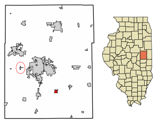
Philo is a village about nine miles south of Urbana in Champaign County, Illinois, United States. The population was 1,392 at the 2020 census.

<span class="mw-page-title-main">Deer Park, Illinois</span> Village in Illinois, United States

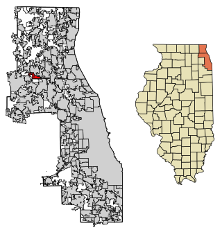
Deer Park is a village in Lake and Cook Counties, Illinois. Per the 2020 census, the population was 3,681. The village is one of the few left in the Chicago area that enjoy a green belt which is bordered by two large natural areas providing outdoor recreation and open space. The village is home to popular shopping and dining destinations: Deer Park Town Center and the Town Center Promenade. The town is also home to the Vehe Farm, an Illinois Centennial Farm.

<span class="mw-page-title-main">Edgewood, Illinois</span> Village in Illinois, United States

Edgewood is a village in Effingham County, Illinois, United States. The population was 440 at the 2010 census, down from 527 at the 2000 census. Edgewood is part of the Effingham, IL Micropolitan Statistical Area.

<span class="mw-page-title-main">Piper City, Illinois</span> Village in Illinois, United States

Piper City is a village in Ford County, Illinois, United States. The population was 826 at the 2010 census.

<span class="mw-page-title-main">Omaha, Illinois</span> Village in Illinois, United States

Omaha is a village in Gallatin County, Illinois, United States. The population was 266 at the 2010 census.

<span class="mw-page-title-main">Ridgway, Illinois</span> Village in Illinois, United States

Ridgway is a village in Gallatin County, Illinois, United States. As of the 2020 census, the population was 851. As of 2018, Rebecca Mitchell was the town mayor.

<span class="mw-page-title-main">New Burnside, Illinois</span> Village in Illinois, United States

New Burnside is a village in Johnson County, Illinois, United States. The population was 211 at the 2010 census.

<span class="mw-page-title-main">Bonfield, Illinois</span> Village in Illinois, United States

Bonfield is a village in Kankakee County, Illinois, United States. Bonfield's population was 382 at the 2010 census. It is included in the Kankakee-Bradley, Illinois Metropolitan Statistical Area.

<span class="mw-page-title-main">Lake Villa, Illinois</span> Village in Illinois, United States

Lake Villa is a village in Lake County, Illinois United States. Per the 2020 census, the population was 8,741. Lake Villa lies within Lake Villa Township and about 50 miles north of Chicago and is part of the United States Census Bureau's Chicago combined statistical area (CSA).

<span class="mw-page-title-main">Chatsworth, Illinois</span> Town in Illinois, United States

Chatsworth is an incorporated town in Livingston County, Illinois, United States. The population was 1,332 at the 2020 census.

<span class="mw-page-title-main">Cornell, Illinois</span> Village in Illinois, United States

Cornell is a village in Livingston County, Illinois, United States. The population was 467 at the 2010 census.

<span class="mw-page-title-main">Cullom, Illinois</span> Village in Illinois, United States

Cullom is a village in Livingston County, Illinois, United States. Cullom is situated twenty miles east of Pontiac which is the county seat, and is one mile west of the Ford County line. The population was 555 at the 2010 census.

<span class="mw-page-title-main">Worden, Illinois</span> Village in Illinois, United States

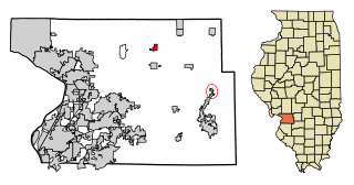
Worden is a village in Madison County, Illinois, United States. The population was 1,096 at the 2020 census.

<span class="mw-page-title-main">Creston, Illinois</span> Village in Illinois, United States

Creston is a village in Ogle County, Illinois, United States. The population was 627 at the 2020 census, down from 662 in 2010.

<span class="mw-page-title-main">Davis Junction, Illinois</span> Village in Illinois, United States

Davis Junction is a village in Ogle County, Illinois, United States. The population was 2,512 at the 2020 census. Named for Jeremiah Davis, it is located where the Illinois Railway Rockford Line and the Canadian Pacific Railway Chicago Subdivision intersect along Illinois Route 72. It is the site of the Orchard Hills Landfill - one of the largest in the United States.

<span class="mw-page-title-main">Stonefort, Illinois</span> Village in Illinois, United States

Stonefort is a village in Saline and Williamson Counties, Illinois, United States. The population was 297 at the 2010 census.

<span class="mw-page-title-main">Rankin, Illinois</span> Village in Illinois, United States

Rankin is a village in Butler Township, Vermilion County, Illinois, United States. It is part of the Danville, Illinois Metropolitan Statistical Area. The population was 561 at the 2010 census.

References

  1. "2020 U.S. Gazetteer Files". United States Census Bureau. Retrieved March 15, 2022.
  2. 1 2 U.S. Geological Survey Geographic Names Information System: Crossville, Illinois
  3. Inter-State Publishing Company (1883). The History of White County, Illinois. Inter-State Publishing Company. p. 921.
  4. Crossville Centennial History Committee (1995). The Centennial History of Crossville & Phillips Township. Crossville Centennial History Committee. p. 18.
  5. Patricia S. Davis (1998). Carmi Times Sesquicentennial Edition, December 9, 1965. publisher not known. p. 132.
  6. Crossville Centennial History Committee (1995). The Centennial History of Crossville & Phillips Township. Crossville Centennial History Committee. p. 15.
  7. Haley Church, "Illinois Gov. Rauner Visits Tornado-Ravaged Crossville," Mount Carmel Register, 3 March 2017.
  8. "US Gazetteer files: 2010, 2000, and 1990". United States Census Bureau. February 12, 2011. Retrieved April 23, 2011.
  9. "G001 - Geographic Identifiers - 2010 Census Summary File 1". United States Census Bureau. Archived from the original on February 13, 2020. Retrieved August 2, 2015.
  10. "Census of Population and Housing". Census.gov. Retrieved June 4, 2015.
  11. "U.S. Census website". United States Census Bureau . Retrieved January 31, 2008.