Phillipstown | |
---|---|
Coordinates: 38°8′42″N88°1′13″W / 38.14500°N 88.02028°W Coordinates: 38°8′42″N88°1′13″W / 38.14500°N 88.02028°W | |
Country | United States |
State | Illinois |
County | White |
Area | |
• Total | 0.27 sq mi (0.70 km2) |
• Land | 0.27 sq mi (0.70 km2) |
• Water | 0.00 sq mi (0.00 km2) |
Population (2020) | |
• Total | 34 |
• Density | 125.93/sq mi (48.54/km2) |
Time zone | UTC-6 (CST) |
• Summer (DST) | UTC-5 (CDT) |
ZIP Code(s) | 62827 |
Area code | 618 |
FIPS code | 17-59520 |
Wikimedia Commons | Phillipstown, Illinois |
Phillipstown is a village in White County, Illinois, United States. The population was 28 at the 2000 census.
Phillipstown was surveyed for Caleb Clifford on February 19, 1839 and the plat was recorded on January 2, 1843. [2] It was originally named Victoria, but at that time the name was already in use by another post office in Illinois, so a new name had to be chosen. By order of the State Legislature, on January 29, 1840 it was renamed in honor of Major Alexander Phillips, [3] an early settler of the area who had made a land entry for an adjoining property in 1817 while the area was still part of Illinois Territory. [4]
The land upon which Phillipstown was platted had originally been entered by James Phillips, who quite likely was Alexander Phillips' father. James' interest in the land was sold to David Phillips and John McClure Graham (husband of Rebecca Phillips), who received a patent to the land on November 15, 1830 (David and Rebecca were likely siblings of Alexander). [5] They sold the property to Major Alexander Phillips on January 6, 1837. On February 17, 1837, he sold the property to Caleb Clifford. [6]
In addition to his service during the War of 1812, Major Alexander Phillips was also elected to serve in the House of Representatives for White County, Illinois in the 1st, 2nd, 3rd, 4th, 11th & 12th Illinois General Assemblies. [7]
Phillipstown is located at 38°8′42″N88°1′13″W / 38.14500°N 88.02028°W (38.145033, -88.020172). [8]
According to the 2010 census, Phillipstown has a total area of 0.27 square miles (0.70 km2), all land. [9]
Historical population | |||
---|---|---|---|
Census | Pop. | %± | |
1900 | 100 | — | |
1910 | 105 | 5.0% | |
1920 | 70 | −33.3% | |
1930 | 47 | −32.9% | |
1940 | 53 | 12.8% | |
1950 | 102 | 92.5% | |
1960 | 69 | −32.4% | |
1970 | 55 | −20.3% | |
1980 | 37 | −32.7% | |
1990 | 48 | 29.7% | |
2000 | 28 | −41.7% | |
2010 | 44 | 57.1% | |
2020 | 34 | −22.7% | |
U.S. Decennial Census [10] |
As of the census [11] of 2000, there were 28 people, 13 households, and 7 families residing in the village. The population density was 103.3 inhabitants per square mile (39.9/km2). There were 15 housing units at an average density of 55.3 per square mile (21.4/km2). The racial makeup of the village was 100.00% White.
There were 13 households, out of which 15.4% had children under the age of 18 living with them, 61.5% were married couples living together, and 38.5% were non-families. 30.8% of all households were made up of individuals, and 15.4% had someone living alone who was 65 years of age or older. The average household size was 2.15 and the average family size was 2.75.
In the village, the population was spread out, with 14.3% under the age of 18, 7.1% from 18 to 24, 35.7% from 25 to 44, 17.9% from 45 to 64, and 25.0% who were 65 years of age or older. The median age was 42 years. For every 100 females, there were 86.7 males. For every 100 females age 18 and over, there were 100.0 males.
The median income for a household in the village was $42,917, and the median income for a family was $44,167. Males had a median income of $43,125 versus $43,750 for females. The per capita income for the village was $21,188. There were no families and 4.0% of the population living below the poverty line, including no under eighteens and none of those over 64.
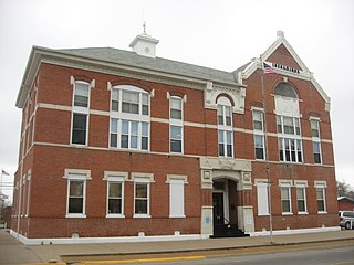
White County is a county located in the U.S. state of Illinois. According to the 2010 census, it had a population of 14,665. Its county seat is Carmi. It is located in the southern portion of Illinois known locally as "Little Egypt".
Beaverton is a town in Lamar County, Alabama, United States. At the 2010 census the population was 201, down from 226 in 2000.
Iola is a village in Clay County, Illinois, United States. The population was 98 at the 2020 census.
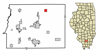
Montrose is a village in Effingham and Cumberland counties in the U.S. state of Illinois. The population was 210 at the 2020 census. The Effingham County portion of Montrose is part of the Effingham Micropolitan Statistical Area, while the small section that lies in Cumberland County is part of the Charleston–Mattoon Micropolitan Statistical Area.
Toledo is a village in and the county seat of Cumberland County, Illinois, United States. The population was 1,238 at the 2010 census.
Wapella is a village in DeWitt County, Illinois, United States. The population was 558 at the 2010 census.
St. Peter is a village in Fayette County, Illinois, United States. The population was 359 at the 2010 census.
Ewing is a village in Franklin County, Illinois, United States. The population was 307 at the 2010 census.
Macedonia is a village in Franklin and Hamilton counties, Illinois, United States. The population was 63 at the 2010 census.
Wheeler is a village in Jasper County, Illinois, United States. The population was 147 at the 2010 census.
Simpson is a village in Johnson County, Illinois, United States. The population was 60 at the 2010 census.
Virgil is a village in Virgil Township, Kane County, Illinois, United States. It was incorporated on November 6, 1990. The population was 329 at the 2010 census, up from 266 in 2000.
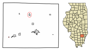
Kangley is a village in LaSalle County, Illinois, United States. The population was 235 at the 2020 census, down from 251 at the 2010 census. It is part of the Ottawa Micropolitan Statistical Area. It is a part of the geographic region known as Streatorland.
Grand Chain is a village in Pulaski County, Illinois, United States. The population was 190 at the 2010 census. The village's official name changed from "Grand Chain" to "New Grand Chain" in the 1970s, but its residents continue to refer to it as "Grand Chain."
Tilden is a village in Randolph County, Illinois, United States. The population was 934 at the 2010 census.
Keenes is a village in Wayne County, Illinois, United States. The population was 99 at the 2000 census.
Mill Shoals is a village in Wayne and White counties in the U.S. state of Illinois. The population was 235 at the 2000 census, down to 176 at the 2020 census.
Burnt Prairie is a village in White County, Illinois, United States. The population was 58 at the 2000 census.
Crossville is a village in White County, Illinois, United States. The population was 745 at the 2010 census.
Maunie is a village in White County, Illinois, United States. The population was 177 at the 2000 census.