Mascoutah, Illinois

Last updated

Mascoutah, Illinois
Main Street, Mascoutah, Illinois.JPG
Main Street, 2006
Flag of Mascoutah, Illinois.png
Seal of Mascoutah, Illinois.png
St. Clair County Illinois Incorporated and Unincorporated areas Mascoutah Highlighted.svg
Location of Mascoutah in St. Clair County, Illinois.
Coordinates: 38°29.5′N89°47.8′W / 38.4917°N 89.7967°W / 38.4917; -89.7967
Country Flag of the United States.svg  United States
State Flag of Illinois.svg  Illinois
County St. Clair
Area
[1]
  Total9.72 sq mi (25.19 km2)
  Land9.58 sq mi (24.81 km2)
  Water0.15 sq mi (0.38 km2)
Elevation
[2]
433 ft (132 m)
Population
 (2020)
  Total8,754
  Density913.97/sq mi (352.90/km2)
Time zone UTC-6 (CST)
  Summer (DST) UTC-5 (CDT)
ZIP Code(s)
62258
Area code 618
FIPS code 17-47423
GNIS feature ID2395038 [2]
Wikimedia CommonsMascoutah, Illinois
Website www.mascoutah.org

Mascoutah is a city in St. Clair County, Illinois, United States. The population was 8,754 at the 2020 census. It is part of the Metro East region of Greater St. Louis. The city was named for the Mascoutens, a tribe of Algonquian-speaking Native Americans. [3]

Contents

History

Mascoutah in 1938 Illinois - Mascoutah through McLeansboro - NARA - 23939869 (cropped).jpg
Mascoutah in 1938

The town of Mascoutah was originally established in 1837 as Mechanicsburg. This was disputed with the establishment of a Post Office; the inhabitants were informed that another township in Illinois was already named Mechanicsburg. The town was renamed after the Mascouten tribe, and was officially designated Mascoutah in 1839. [4] [3]

Mascoutah was considered a progressive town near the turn of the 20th century. The town saw steady growth thanks to the construction of a train depot in 1870, courtesy of the St. Louis and Southeastern Railway (later the Louisville and Nashville). The largest Turner Hall in Southern Illinois was established in Mascoutah in 1873 [5] which served as the center of town social life, and the town constructed its own citizen owned power plant in 1894. The Mascoutah Herald was established in 1885 and remains in production to this day. [6] [7] In 1903 the Belleville And Mascoutah Electric Railway Company planned an electric rail system to Belleville that was delayed and never completed. [5]

The train depot shut down, the Turner Hall eventually became the chamber of commerce, and the municipal power plant now houses the city's fleet and equipment maintenance department. [8]

Geography

The Mascoutah Civic Center is located at 38°29.5′N89°47.8′W / 38.4917°N 89.7967°W / 38.4917; -89.7967 (38.4922, -89.7968). [9]

According to the 2010 census, Mascoutah has a total area of 9.65 square miles (24.99 km2), of which 9.5 square miles (24.60 km2) (or 98.45%) is land and 0.15 square miles (0.39 km2) (or 1.55%) is water. [10]

Demographics

Historical population
CensusPop.Note
1860 2,076
1870 2,79034.4%
1880 2,558−8.3%
1890 2,032−20.6%
1900 2,1716.8%
1910 2,081−4.1%
1920 2,34312.6%
1930 2,311−1.4%
1940 2,294−0.7%
1950 3,00931.2%
1960 3,62520.5%
1970 5,04539.2%
1980 4,962−1.6%
1990 5,51111.1%
2000 5,6592.7%
2010 7,48332.2%
2020 8,75417.0%
U.S. Decennial Census [11]

Mascoutah was the United States center of population point in 1970. As of the census [12] of 2000, there were 5,659 people, 2,162 households, and 1,571 families residing in the city. The population density was 655.1 inhabitants per square mile (252.9/km2). There were 2,309 housing units at an average density of 267.3 per square mile (103.2/km2). The racial makeup of the city was 91.73% White, 4.19% African American, 0.35% Native American, 0.97% Asian, 0.05% Pacific Islander, 0.85% from other races, and 1.86% from two or more races. Hispanic or Latino of any race were 1.75% of the population.

There were 2,162 households, out of which 35.8% had children under the age of 18 living with them, 57.5% were married couples living together, 11.2% had a female householder with no husband present, and 27.3% were non-families. 23.7% of all households were made up of individuals, and 10.5% had someone living alone who was 65 years of age or older. The average household size was 2.57 and the average family size was 3.05.

In the city, the population was spread out, with 26.4% under the age of 18, 8.5% from 18 to 24, 29.4% from 25 to 44, 21.5% from 45 to 64, and 14.2% who were 65 years of age or older. The median age was 38 years. For every 100 females, there were 92.4 males. For every 100 females age 18 and over, there were 90.1 males.

The median income for a household in the city was $46,451, and the median income for a family was $55,018. Males had a median income of $37,182 versus $23,156 for females. The per capita income for the city was $21,569. About 6.3% of families and 7.8% of the population were below the poverty line, including 11.8% of those under age 18 and 7.9% of those age 65 or over.

Location

Mascoutah is located about 7 km (4 mi) south of Interstate 64 (Exit 23) on Highway 4 at Highway 177. It is about 46 km (29 mi) east St. Louis, Missouri. Mascoutah is accessible to St. Louis and Lambert Airport by Metrolink from its Shiloh station a few miles northwest of town. Mascoutah is home to Mid America Airport. Nearby Scott AFB is a major employer and base residents attend school in Mascoutah. Downtown St. Louis is 30 minutes away, West County St Louis is 45 minutes away, and South County St Louis is 35 minutes away.

Parks

There are three parks in town that offer a wide array of activities. Scheve Park has two swimming pools, 6 baseball diamonds (2 with lights), a large dog park, lit sand volleyball court, lit horseshoe pits, two soccer fields, a disc golf course with 18 tee boxes shooting to 9 targets, a skate park, ten pavilions varying in size, and several playground areas. Scheve Park also has a restored train caboose and dining car that visitors can tour. Maple Park is equipped with outdoor basketball facilities, a ball playing area, playground equipment, and a family sized pavilion. Prairie Park has two fishing lakes, 3 lighted colored fountains, picnic tables with grills and a pavilion. [13] [14] [15]

Education

Mascoutah Community Unit School District#19 serves the city. There are five schools in the district: Mascoutah Community High School, Mascoutah Middle School, Mascoutah Elementary School, Scott Air Force Base Elementary School, and Wingate Elementary School.

Holy Childhood School is the private Catholic school in Mascoutah. It offers preschool through eighth grade.

People

Related Research Articles

<span class="mw-page-title-main">St. Clair County, Illinois</span> County in Illinois, United States

St. Clair County is the ninth most populous county in Illinois. Located directly east of St. Louis, the county is part of the Metro East region of the Greater St. Louis metropolitan area in southern Illinois. As of the 2020 United States census, St. Clair County had a population of 257,400, making it the third most populous county in Illinois outside the Chicago metropolitan area. Belleville is the county’s seat and largest city.

<span class="mw-page-title-main">Fairmont City, Illinois</span> Village in Illinois, United States

Fairmont City is a village in St. Clair and Madison counties, Illinois, United States. The population was 2,265 at the 2020 census, down from 2,635 in 2010. In the 1990s Fairmont City's Hispanic population doubled, and as of 2020, over 79% of the population was of Hispanic descent.

<span class="mw-page-title-main">Glen Carbon, Illinois</span> Village in Illinois, United States

Glen Carbon is a village in Madison County, Illinois, United States, 14 miles (23 km) northeast of St. Louis. The population was 13,842 at the 2020 census.

<span class="mw-page-title-main">Madison, Illinois</span> City in Illinois, United States

Madison is a city in Madison and St. Clair counties in the U.S. state of Illinois. The population was 3,171 at the 2020 census, down from 3,891 in 2010. It is home to World Wide Technology Raceway at Gateway and the first Bulgarian Orthodox church in the United States.

<span class="mw-page-title-main">Troy, Illinois</span> City in Illinois, United States

Troy is a city in Madison County, Illinois, United States. The population was 10,960 at the 2020 census, up from 9,888 in 2010.

<span class="mw-page-title-main">Columbia, Illinois</span> City in Illinois, United States

Columbia is a city mainly in Monroe County with a small portion in St. Clair County in the U.S. state of Illinois, about 12 miles (19 km) south of St. Louis, Missouri. The population was 10,999 at the 2020 census.

<span class="mw-page-title-main">Nokomis, Illinois</span> City in Illinois, United States

Nokomis is a city in Montgomery County, Illinois, United States. The population was 2,142 at the 2020 census.

<span class="mw-page-title-main">Pinckneyville, Illinois</span> City in Illinois, United States

Pinckneyville is a city in and the county seat of Perry County, Illinois, United States. The population was 5,066 at the 2020 census. It is named for Charles Cotesworth Pinckney, an early American diplomat and presidential candidate.

<span class="mw-page-title-main">Alorton, Illinois</span> Village in Illinois, United States

Alorton was a village in St. Clair County, Illinois, United States. Incorporated in 1944, it was one of three municipalities that merged to form the city of Cahokia Heights on May 6, 2021; the other two were the village of Cahokia and the city of Centreville. Prior to merger, Alorton had a population of 1,566 and land area of 1.8 square miles (4.7 km2) in the 2020 Census.

<span class="mw-page-title-main">Belleville, Illinois</span> City in Illinois, United States

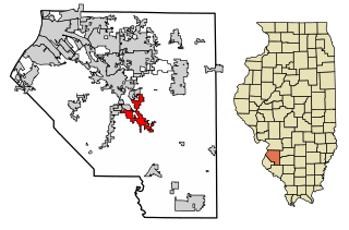
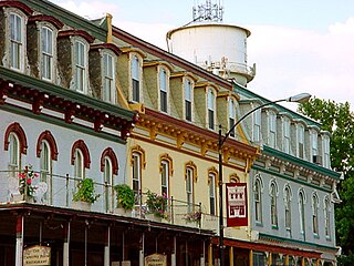
Belleville is a city and the county seat of St. Clair County, Illinois, United States. It is located within Greater St. Louis. The population was 42,404 at the 2020 census, making it the most-populated city in Southern Illinois and in the Metro East region of Greater St. Louis. Due to its proximity to Scott Air Force Base, the population receives a boost from military and federal civilian personnel, defense contractors, and military retirees. It is also the seat of the Roman Catholic Diocese of Belleville and the National Shrine of Our Lady of the Snows.

<span class="mw-page-title-main">Centreville, Illinois</span> City in Illinois, United States

Centreville was a city in St. Clair County, Illinois, United States. The population was 5,309 in 2010, down from 5,951 at the 2000 census. On May 6, 2021, the city ceased to exist, being incorporated into the new city of Cahokia Heights.

<span class="mw-page-title-main">Fairview Heights, Illinois</span> City in Illinois, United States

Fairview Heights is a city in St. Clair County, Illinois, United States within Greater St. Louis. It is an eastern suburb of St. Louis. The population was 17,078 at the 2010 census. Fairview Heights is a dominant shopping center for Greater St. Louis and Southern Illinois and includes numerous shopping plazas and St. Clair Square mall.

<span class="mw-page-title-main">Freeburg, Illinois</span> Village in Illinois, United States

Freeburg is a village in St. Clair County, Illinois, United States. Located within Greater St. Louis, it is a southeastern exurb with many residents commuting to Downtown St. Louis or the Belleville area for employment. As of 2010, Freeburg had a population of 4,354.

<span class="mw-page-title-main">Lebanon, Illinois</span> City in Illinois, United States

Lebanon is a city in St. Clair County, Illinois, United States. The population was 4,691 at the 2020 census It is a part of the Metro East region of the Greater St. Louis metropolitan area. Lebanon is home to McKendree University, the oldest college in Illinois.

<span class="mw-page-title-main">New Athens, Illinois</span> Village in Illinois, United States

New Athens is a village in St. Clair County, Illinois, United States. Based upon common usage, the 'A' is always sounded with a long vowel, rather than a short vowel, by its residents, unlike the most commonly used English pronunciation of the city in Greece.

<span class="mw-page-title-main">O'Fallon, Illinois</span> City in Illinois, United States

O'Fallon is a city in St. Clair County, Illinois, United States. The 2020 census listed the population at 32,289. The city is the second largest city in the Metro East region of the St. Louis metropolitan area and Southern Illinois. It sits 5 miles (8.0 km) from Scott Air Force Base and 18 miles (29 km) from Downtown St. Louis.

<span class="mw-page-title-main">Swansea, Illinois</span> Village in Illinois, United States

Swansea is a village in St. Clair County, Illinois. It is a part of the St. Louis metropolitan area and Metro East in southern Illinois. It is surrounded by the communities of Fairview Heights, Belleville, O’Fallon, and Shiloh. The population was 13,430 at the 2010 census, an increase from 10,579 in 2000.

<span class="mw-page-title-main">Washington Park, Illinois</span> Village in Illinois, United States

Washington Park is a village in St. Clair County, Illinois, United States. The population was 2,592 as of the 2020 census, down from 4,196 in 2010.

<span class="mw-page-title-main">Hazelwood, Missouri</span> City in Missouri, United States

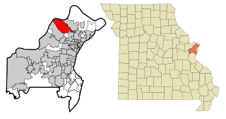
Hazelwood is a city in St. Louis County, Missouri, within Greater St. Louis. It is a second-ring northern suburb of St. Louis. Based on the 2020 United States census, the city had a total population of 25,485. It is located north of St. Louis-Lambert International Airport and is situated on Interstates 270 and 170, as well as the much-traveled Lindbergh Boulevard and Highway 370.

<span class="mw-page-title-main">St. Peters, Missouri</span> City in east central Missouri, U.S.

St. Peters is a city in St. Charles County, Missouri, United States. The population was 57,732 at the 2020 census, making it the eleventh-largest city in Missouri. It is a northwestern suburb of St. Louis.

References

  1. "2020 U.S. Gazetteer Files". United States Census Bureau. Retrieved March 15, 2022.
  2. 1 2 U.S. Geological Survey Geographic Names Information System: Mascoutah, Illinois
  3. 1 2 "History of Mascoutah". Mascoutah, Illinois. City of Mascoutah. Retrieved May 21, 2016.
  4. Illinois (1839). Laws of the State of Illinois Enacted by the ... General Assembly at the Extra Session ... Illinois State Journal Company, State Printers.
  5. 1 2 Snyder, Thomas S. (October 11, 2010). Mascoutah. Arcadia Publishing. ISBN   9781439640975.
  6. Bateman, Newton; Selby, Paul; McLean, Alexander; Wilderman, Alonzo St Clair; Wilderman, Augusta A. (1907). Historical Encyclopedia of Illinois. Munsell Publishing Company. p.  770. mascoutah.
  7. "Home". Herald Publications. Retrieved July 5, 2017.
  8. "Electric | City of Mascoutah IL". www.mascoutah.org. Retrieved September 13, 2018.
  9. "US Gazetteer files: 2010, 2000, and 1990". United States Census Bureau. February 12, 2011. Retrieved April 23, 2011.
  10. "G001 - Geographic Identifiers - 2010 Census Summary File 1". United States Census Bureau. Archived from the original on February 13, 2020. Retrieved December 27, 2015.
  11. "Census of Population and Housing". Census.gov. Retrieved June 4, 2015.
  12. "U.S. Census website". United States Census Bureau . Retrieved January 31, 2008.
  13. "Parks & Recreation - Mascoutah, Illinois". mascoutah.com. Retrieved March 8, 2015.
  14. "Scheve Park - Mascoutah - RecreationParks.net". recreationparks.net. Archived from the original on September 24, 2015. Retrieved March 8, 2015.
  15. "I Fish Illinois--Kids fishing". ifishillinois.org. Retrieved March 8, 2015.