Rosewood Heights, Illinois

Last updated

Rosewood Heights, Illinois
USA Illinois location map.svg
Red pog.svg
Rosewood Heights
Usa edcp location map.svg
Red pog.svg
Rosewood Heights
Coordinates: 38°53′29″N90°4′19″W / 38.89139°N 90.07194°W / 38.89139; -90.07194
CountryUnited States
StateIllinois
County Madison
Township Wood River
Area
[1]
  Total1.674 sq mi (4.34 km2)
  Land1.671 sq mi (4.33 km2)
  Water0.003 sq mi (0.008 km2)
Elevation
535 ft (163 m)
Population
 (2020) [2]
  Total3,971
  Density2,376.4/sq mi (917.5/km2)
Time zone UTC-6 (CST)
  Summer (DST) UTC-5 (CDT)
ZIP Codes
62024 (East Alton)
62018 (Cottage Hills)

Rosewood Heights is an unincorporated community and census-designated place (CDP) in Madison County, Illinois, United States. The population was 3,971 at the 2020 census. [2] It is part of the Metro East region of the Greater St. Louis metropolitan area.

Contents

Geography

Rosewood Heights is located in northwestern Madison County at 38°53′29″N90°4′19″W / 38.89139°N 90.07194°W / 38.89139; -90.07194 (38.891414, -90.071813). [3] It is bordered to the east by Bethalto, to the south by Wood River, to the west by East Alton, and to the north by Cottage Hills.

Illinois Routes 111 and 140 (West MacArthur Drive) form the northern border of the CDP. IL 140 leads west 6 miles (10 km) to Alton and east through Bethalto 12 miles (19 km) to Hamel, while IL 111 leads northwest 9 miles (14 km) to Godfrey and south 4 miles (6 km) to the center of Wood River. Illinois Route 255, a four-lane expressway, runs along the east edge of Rosewood Heights, with access from Exit 10 (IL 111-140). IL 255 leads south 10 miles (16 km) to Interstates 255 and 270 and northwest 9 miles (14 km) to its end at U.S. Route 67 in Godfrey. Downtown St. Louis is 27 miles (43 km) southwest of Rosewood Heights.

According to the United States Census Bureau, the CDP has a total area of 1.7 square miles (4.4 km2), of which 0.003 square miles (0.008 km2), or 0.18%, are water. [1] The community drains northwest toward the East Fork of the Wood River, which joins the Mississippi River at East Alton.

Demographics

At the 2000 census there were 4,262 people, 1,688 households, and 1,299 families living in the CDP. The population density was 1,988.0 inhabitants per square mile (767.6/km2). There were 1,754 housing units at an average density of 818.1 per square mile (315.9/km2). The racial makeup of the CDP was 98.78% White, 0.12% African American, 0.23% Native American, 0.21% Asian, 0.21% from other races, and 0.45% from two or more races. Hispanic or Latino of any race were 0.82%. [4]

Of the 1,688 households 29.7% had children under the age of 18 living with them, 64.5% were married couples living together, 9.1% had a female householder with no husband present, and 23.0% were non-families. 20.0% of households were one person and 10.4% were one person aged 65 or older. The average household size was 2.52 and the average family size was 2.88.

The age distribution was 22.2% under the age of 18, 7.6% from 18 to 24, 26.1% from 25 to 44, 26.0% from 45 to 64, and 18.1% 65 or older. The median age was 41 years. For every 100 females, there were 90.6 males. For every 100 females age 18 and over, there were 90.5 males.

The median household income was $46,701 and the median family income was $53,365. Males had a median income of $44,111 versus $28,176 for females. The per capita income for the CDP was $20,527. About 7.2% of families and 7.8% of the population were below the poverty line, including 8.4% of those under age 18 and 3.2% of those age 65 or over.

Related Research Articles

<span class="mw-page-title-main">Madison County, Illinois</span> County in Illinois, United States

Madison County is a county in the U.S. state of Illinois. It is a part of the Metro East in southern Illinois. According to the 2020 census, it had a population of 264,776, making it the eighth-most populous county in Illinois and the most populous in the southern portion of the state. The county seat is Edwardsville, and the largest city is Granite City.

<span class="mw-page-title-main">Wofford Heights, California</span> Census-designated place in California, United States

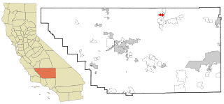
Wofford Heights is a census-designated place (CDP) in the southern Sierra Nevada, in Kern County, California, United States. Wofford Heights is located in the west Kern River Valley, 3.5 miles (5.6 km) south-southwest of Kernville, at an elevation of 2,684 feet (818 m). The population was 2,200 at the 2010 census, down from 2,276 at the 2000 census.

<span class="mw-page-title-main">Channel Lake, Illinois</span> Census-designated place in Illinois, United States

Channel Lake is an unincorporated community and census-designated place (CDP) in Antioch Township, Lake County, Illinois, United States. Per the 2020 census, the population was 1,581.

Long Lake is an unincorporated community and census-designated place (CDP) in Lake County, Illinois, United States. Per the 2020 census, the population was 3,663.

<span class="mw-page-title-main">Bethalto, Illinois</span> Village in the metropolitan area of St. Louis, Missouri

Bethalto is a village in Madison County, Illinois, United States. Bethalto, like the rest of Madison County, is part of the Illinois Metro East portion of the Greater St. Louis metropolitan area.

<span class="mw-page-title-main">East Alton, Illinois</span> Village in Illinois, United States

East Alton is a village in Madison County, Illinois, United States. The population was 5,786 at the 2020 census, down from 6,301 in 2010.

<span class="mw-page-title-main">Godfrey, Illinois</span> Village in Illinois, United States

Godfrey is a village in Madison County, Illinois, United States. The population was 17,825 at the 2020 census. Godfrey is located within the River Bend portion of the Greater St. Louis metropolitan area.

<span class="mw-page-title-main">Pontoon Beach, Illinois</span> Village in Illinois, United States

Pontoon Beach is a village in Madison County, Illinois, United States. The population was 5,876 at the 2020 census. It is part of the St. Louis metropolitan area.

<span class="mw-page-title-main">Roxana, Illinois</span> Village in Illinois, United States

Roxana is a village in Madison County, Illinois, United States. The population was 1,454 at the 2020 census. The ZIP Code is 62084.

<span class="mw-page-title-main">South Roxana, Illinois</span> Village in Illinois, United States

South Roxana, incorporated in March 1967, is a village in Madison County, Illinois, United States. The population was 1,891 at the 2020 census.

<span class="mw-page-title-main">Wood River, Illinois</span> City in Illinois, United States

Wood River is a city in Madison County, Illinois. The population was 10,464 as of the 2020 census.

<span class="mw-page-title-main">Fairview Heights, Illinois</span> City in Illinois, United States

Fairview Heights is a city in St. Clair County, Illinois, United States within Greater St. Louis. It is an eastern suburb of St. Louis. The population was 17,078 at the 2010 census. Fairview Heights is a dominant shopping center for Greater St. Louis and Southern Illinois and includes numerous shopping plazas and St. Clair Square mall. Venture Stores opened its first discount department store in 1970 in Fairview Heights at the northwest corner of Illinois Street and Lincoln Trail, which was U.S. Route 50 at the time.

<span class="mw-page-title-main">Preston Heights, Illinois</span> Census-designated place in Illinois, United States

Preston Heights is a census-designated place (CDP) in Will County, Illinois, United States. As of the 2020 census, the CDP population was 2,898.

<span class="mw-page-title-main">Harwich Center, Massachusetts</span> Census-designated place in Massachusetts, United States

Harwich Center is a census-designated place (CDP) in the town of Harwich in Barnstable County, Massachusetts, United States. The population was 1,798 at the 2010 census.

<span class="mw-page-title-main">Shorewood–Tower Hills–Harbert, Michigan</span> Census-designated place & unincorporated communities in Michigan, United States

Shorewood–Tower Hills–Harbert is a census-designated place (CDP) composed of several small unincorporated communities in Chikaming Township of Berrien County in the U.S. state of Michigan. The population was 1,249 at the 2020 census. The CDP is limited to Chikaming Township, although some of the communities extend into southern Lake Township. All of the communities are located either upon or just east of the dunes on the shore of Lake Michigan. Most of the communities lie west of Interstate 94, although the CDP includes a small area east of the freeway up to Sawyer. The township is a popular resort destination.

<span class="mw-page-title-main">Tillson, New York</span> CDP in New York, United States

Tillson is a hamlet in Ulster County, New York, United States. The population was 1,516 at the 2020 census.

Arlington Heights is a census-designated place (CDP) in Monroe County, Pennsylvania, United States. The population was 6,331 at the 2020 census. One notable location in Arlington Heights is the Stroud Mall.

<span class="mw-page-title-main">Del Mar Heights, Texas</span> Census-designated place in Texas, United States

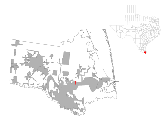
Del Mar Heights is a census-designated place (CDP) in Cameron County, Texas, United States. The population was 113 at the 2010 census. It is part of the Brownsville–Harlingen Metropolitan Statistical Area.

Alton North is a former census-designated place (CDP) in Hidalgo County, Texas, United States. The population was 5,051 at the 2000 census. It is part of the McAllen–Edinburg–Mission Metropolitan Statistical Area.

<span class="mw-page-title-main">Maple Heights-Lake Desire, Washington</span> Census-designated place in Washington, United States

Maple Heights-Lake Desire is a census-designated place (CDP) in King County, Washington, United States. At the 2010 census, the population was 3,152.

References

  1. 1 2 "2022 U.S. Gazetteer Files: Illinois". United States Census Bureau. Retrieved February 22, 2023.
  2. 1 2 "P1. Race – Rosewood Heights CDP, Illinois: 2020 DEC Redistricting Data (PL 94-171)". U.S. Census Bureau. Retrieved February 22, 2023.
  3. "US Gazetteer files: 2010, 2000, and 1990". United States Census Bureau. February 12, 2011. Retrieved April 23, 2011.
  4. "U.S. Census website". United States Census Bureau . Retrieved January 31, 2008.