
Effigy Mounds National Monument preserves more than 200 prehistoric mounds built by pre-Columbian Mound Builder cultures, mostly in the first millennium CE, during the later part of the Woodland period of pre-Columbian North America. Numerous effigy mounds are shaped like animals, including bears and birds.

The Hopewell tradition, also called the Hopewell culture and Hopewellian exchange, describes a network of precontact Native American cultures that flourished in settlements along rivers in the northeastern and midwestern Eastern Woodlands from 100 BCE to 500 CE, in the Middle Woodland period. The Hopewell tradition was not a single culture or society but a widely dispersed set of populations connected by a common network of trade routes.

Otonabee–South Monaghan is a township in central-eastern Ontario, Canada, in Peterborough County. The township, located along the Trent–Severn Waterway, was formed on January 1, 1998, through the amalgamation of Otonabee and South Monaghan Townships.
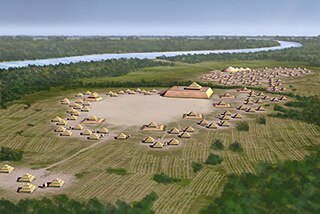
The Pinson Mounds comprise a prehistoric Native American complex located in Madison County, Tennessee, in the region that is known as the Eastern Woodlands. The complex, which includes 17 mounds, an earthen geometric enclosure, and numerous habitation areas, was most likely built during the Middle Woodland period. The complex is the largest group of Middle Woodland mounds in the United States. Sauls' Mound, at 72 feet (22 m), is the second-highest surviving mound in the United States.

The Great Serpent Mound is a 1,348-feet-long (411 m), three-feet-high prehistoric effigy mound located in Peebles, Ohio. It was built on what is known as the Serpent Mound crater plateau, running along the Ohio Brush Creek in Adams County, Ohio. The mound is the largest serpent effigy known in the world.

Rice Lake is a lake located in Northumberland and Peterborough counties in south-eastern Ontario. The lake is located south of the city of Peterborough, and the Kawartha Lakes and north of Cobourg. It is part of the Trent-Severn Waterway, which flows into the lake by the Otonabee and out via the Trent. The lake is 28 kilometres (17 mi) long and 5 km wide. Its maximum depth is 10m, with a surface water level at 187 m above sea level, raised to its present height by the Hastings Dam, built in the 19th century as part of the Trent-Severn canal system. Natives called it Pemadashdakota or "lake of the burning plains".

Lizard Mound State Park is a state park in the Town of Farmington, Washington County, Wisconsin near the city of West Bend. The park contains a significant well-preserved effigy mound group, representing one of the largest and best-preserved collections of such mounds in the state. Mounds in the park are the subject of at least two different listings on the National Register of Historic Places, one encompassing the park as a whole, and another which includes a larger set of regional mounds. Established in 1950, the park was acquired by Washington County from the state of Wisconsin in 1986, and was returned to the state in 2021. It is now managed by the Wisconsin Department of Natural Resources.

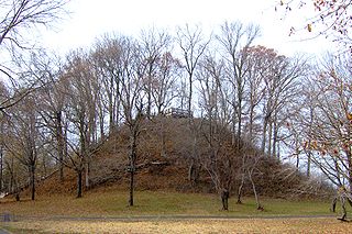
The Grave Creek Mound in the Ohio River Valley in West Virginia is one of the largest conical-type burial mounds in the United States, now standing 62 feet (19 m) high and 240 feet (73 m) in diameter. The builders of the site, members of the Adena culture, moved more than 60,000 tons of dirt to create it about 250–150 BC.

Shiloh Indian Mounds Site (40HR7) is an archaeological site of the South Appalachian Mississippian culture. It is located beside the Tennessee River on the grounds of the Shiloh National Military Park, in Hardin County of southwestern Tennessee. A National Historic Landmark, it is one of the largest Woodland era sites in the southeastern United States.
Spiro Mounds is an Indigenous archaeological site located in present-day eastern Oklahoma. The site was built by people from the Arkansas Valley Caddoan culture. that remains from an American Indian culture that was part of the major northern Caddoan Mississippian culture. The 80-acre site is located within a floodplain on the southern side of the Arkansas River. The modern town of Spiro developed approximately seven miles to the south.

The Kolomoki Mounds is one of the largest and earliest Woodland period earthwork mound complexes in the Southeastern United States and is the largest in Georgia. Constructed from 350CE to 600CE, the mound complex is located in southwest Georgia, in present-day Early County near the Chattahoochee River.

An effigy mound is a raised pile of earth built in the shape of a stylized animal, symbol, religious figure, human, or other figure. The Effigy Moundbuilder culture is primarily associated with the years 550–1200 CE during the Late Woodland Period, although radiocarbon dating has placed the origin of certain mounds as far back as 320 BCE.

The Alligator Effigy Mound is an effigy mound in Granville, Ohio, United States. The mound is believed to have been built between AD 800 and 1200 by people of the Fort Ancient culture. The mound was likely a ceremonial site, as it was not used for burials.

The Hiawatha First Nation is a Mississauga Ojibwe First Nations reserve located on the north shore of Rice Lake east of the Otonabee River in Ontario, Canada.

Taber Hill, also spelled Tabor Hill, is a Wyandot (Huron) burial mound in Toronto, Ontario. It is located northeast of the intersection of Lawrence Avenue and Bellamy Road in Scarborough. It is estimated to date from the 14th century and contain the skeletons of over 500 Huron/Wendat. It is believed to be the only First Nations ossuary protected as a cemetery in Canada.

The Point Peninsula complex was an indigenous culture located in Ontario and New York from 600 BCE to 700 CE. Point Peninsula ceramics were first introduced into Canada around 600 BCE then spread south into parts of New England around 200 BCE. Some time between 300 BCE and 1 CE, Point Peninsula pottery first appeared in Maine, and "over the entire Maritime Peninsula." Little evidence exists to show that it was derived from the earlier, thicker pottery, known as Vinette I, Adena Thick, etc... Point Peninsula pottery represented a new kind of technology in North America and has also been called Vinette II. Compared to existing ceramics that were thicker and less decorated, this new pottery has been characterized by "superior modeling of the clay with vessels being thinner, better fired and containing finer grit temper." Where this new pottery technology originated is not known for sure. The origin of this pottery is "somewhat of a problem." The people are thought to have been influenced by the Hopewell traditions of the Ohio River valley. This influence seems to have ended about 250 CE, after which they no longer practiced burial ceremonialism.
Grand Mound is a prehistoric burial site in Koochiching County, Minnesota, United States. It is the largest surviving prehistoric structure in the upper Midwest, dating back to 200 BCE. The site was listed as a National Historic Landmark on June 23, 2011.
The Kay-Nah-Chi-Wah-Nung Historical Centre, or Manitou Mounds, is Canada's premier concentration of ancient burial mounds. Manitou Mounds National Historic Site, as it was once called, is a vast network of 30 village sites and 15 ancient burial mounds constructed from approximately 5000 BP during the Archaic Period, to 360 BP; it is one of the "most significant centres of early habitation and ceremonial burial in Canada." It is located on a river stretch known as Long Sault Rapids on the north side of Rainy River, approximately 54 kilometres (34 mi) east of Fort Frances, in the Rainy River District of Northwestern Ontario, Canada off highway 11. It was designated as a National Historic Site of Canada in 1969.
Hiwassee Island, also known as Jollys Island and Benham Island, is located in Meigs County, Tennessee, at the confluence of the Tennessee and Hiwassee Rivers. It is about 35 mi (56 km) northeast of Chattanooga. The island was the second largest land mass on the Tennessee River at 781 acres before the Tennessee Valley Authority created the Chickamauga Lake as a part of the dam system on the Tennessee River in 1940. Much of the island is now submerged, leaving 400 acres above the waterline.

The Knowes of Trotty is a Bronze Age cemetery located in Mainland, Orkney in Scotland. The ancient site consists of a group of twelve surviving burial mounds, dating to 2030–1770 BC. Along with cremated human remains, four gold discs and a number of amber beads and pendants were discovered in the largest mound in 1858. Knowes of Trotty is one of the earliest group of burial mounds in Orkney and one of the largest Bronze Age cemeteries in the United Kingdom.


