Bonnechere Provincial Park

Last updated
Bonnechere Provincial Park
Bonnechere campground.JPG
The Bonnechere River in autumn as it snakes through the park campground.
Canada Southern Ontario location map 2.png
Red pog.svg
Location Round Lake (Ontario)
Nearest city Pembroke, Ontario
Coordinates 45°39′32″N77°34′23″W / 45.659°N 77.573°W / 45.659; -77.573 Coordinates: 45°39′32″N77°34′23″W / 45.659°N 77.573°W / 45.659; -77.573
Area162 hectares (400 acres)
Established1967
Governing body Ontario Parks

Bonnechere Provincial Park is an Ontario provincial park located on Round Lake in Renfrew County, Ontario, Canada.

Contents

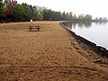
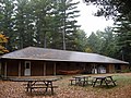
Designated as recreational-class by Ontario Parks, it has 128 campsites, 4 rustic cabins [1] and a day use area, which includes a shower station, playground and a beach.

See also

Related Research Articles

<span class="mw-page-title-main">Madawaska River (Ontario)</span> River in Ontario, Canada

The Madawaska River is a river in the Saint Lawrence River drainage basin in Ontario, Canada. The river is 230 km (143 mi) long and drains an area of 8,470 km2 (3,270 sq mi). Its name comes from an Algonquian band of the region known as "Matouweskarini", meaning "people of the shallows".

<span class="mw-page-title-main">Mattawa River</span> River in Ontario, Canada

The Mattawa River is a river in central Ontario, Canada. It flows east from Trout Lake east of North Bay and enters the Ottawa River at the town of Mattawa. Counting from the head of Trout Lake, it is 76 km in length. The river's name comes from the Algonquin word for "meeting of waterways".

The Brent crater is an impact crater in both the geographic township of Deacon, Unorganized South Nipissing District and the municipal township of Papineau-Cameron in Nipissing District, northeastern Ontario, Canada, located north of Cedar Lake in northern Algonquin Provincial Park. It is 3.8 kilometres (2.4 mi) in diameter and the age is estimated to be ca. 453 million years (Ordovician). The crater can be reached using Brent Road, 32 kilometres (20 mi) south of Ontario Highway 17.

<span class="mw-page-title-main">Bonnechere River</span> River in Ontario, Canada

The Bonnechere River is a river in the Saint Lawrence River drainage basin in Nipissing District and Renfrew County in eastern and northeastern Ontario, Canada. The river flows from Algonquin Provincial Park to the Ottawa River east and north of the town of Renfrew. The river's name is thought to come from the French "bonne chère" meaning "good cheer".

<span class="mw-page-title-main">MacGregor Point Provincial Park</span>

MacGregor Point Provincial Park is a park located on Lake Huron, off of Bruce Road 33 near Port Elgin, Ontario, Canada.

Hilliard's Bay Provincial Park is a provincial park in Alberta, Canada. It is located 40 km (25 mi) from High Prairie, on the north-western shore of Lesser Slave Lake in northern Alberta.

<span class="mw-page-title-main">White Lake Provincial Park (Ontario)</span> Provincial park in Ontario

White Lake Provincial Park is a park in the Thunder Bay District of Northern Ontario, Canada, along Highway 17, north of Lake Superior.

<span class="mw-page-title-main">Bonnechere River Provincial Park</span>

Bonnechere River Provincial Park is located along the Bonnechere River in Ontario, Canada. A 23 km (14 mi) long section of the Bonnechere River, starting at the Algonquin Park boundary and terminating at Bonnechere Provincial Park, has been protected as a waterway provincial park. It is a "non-operating" park, meaning no fees are charged and no staff are present with only a few services offered.

King's Highway 62, commonly referred to as Highway 62, is a provincially maintained highway in the Canadian province of Ontario. The highway travels south–north from Highway 33 at Bloomfield in Prince Edward County, through Belleville, Madoc and Bancroft, to Maynooth, where it ends at a junction with Highway 127. Prior to 1997, the route continued north and east of Maynooth through Cobermere, Barry's Bay, Killaloe, Round Lake and Bonnechere to Highway 17 in Pembroke. This section of highway was redesignated Hastings Highlands Municipal Road 62, Renfrew County Road 62, and Renfrew County Road 58.

<span class="mw-page-title-main">Centennial Parkway</span>

Centennial Parkway, is an arterial road in southeastern Hamilton, Ontario, Canada. It is best known as the western terminus of former King's Highway 20, now maintained by the City of Hamilton. It starts off as Upper Centennial Parkway, a mountain-access road in the City right before the Canadian Pacific Railway line at the backend of Battlefield Park and is a two-way street throughout that extends north over the Queen Elizabeth Way and ends at Beach Boulevard/ Van Wagners Beach Road in front of Confederation Park.

<span class="mw-page-title-main">Foy Provincial Park</span>

Foy Provincial Park is a provincial park on Round Lake, Ontario. Since it is non-operational, camping is prohibited, but day use activities such as swimming and hiking are permitted. The park property includes facilities used by the Ontario Ranger program of the Ministry of Natural Resources.

<span class="mw-page-title-main">Killaloe, Hagarty and Richards</span> Township in Ontario, Canada

Killaloe, Hagarty and Richards is an incorporated township in Renfrew County in eastern Ontario, Canada, created on July 1, 2000, as a result of an amalgamation of the Township of Hagarty and Richards with the Village of Killaloe.

<span class="mw-page-title-main">Manitou Islands (Lake Nipissing)</span>

The Manitou Islands are a series of small islands in Lake Nipissing, in Nipissing District, Ontario, Canada. The islands form a circle and lie 10 kilometres (6 mi) southwest of North Bay.

<span class="mw-page-title-main">Round Lake (Ontario)</span> Body of water

Round Lake is a lake located in Killaloe, Hagarty and Richards Township, Renfrew County, Ontario, Canada. The Bonnechere River flows into the lake in the northwest and flows out of the lake at the southeast.

<span class="mw-page-title-main">Opeongo Hills</span>

The Opeongo Hills are a range of hills in Southern Ontario, near Algonquin Provincial Park. The hills stretch from Opeongo Lake in Algonquin Park in the west, along the Madawaska and Opeongo Rivers, towards the Opeongo Colonization Road, and extending towards the Deacon Escarpment, Bonnechere, Ontario, and Dacre in the east. To the east of the Opeongo Hills lie the Madawaska River valley, the Mississippi River Valley, and the Ottawa-Bonnechere Graben along the Ottawa River. Its tallest peak is roughly 7 km northeast of Highway 60. At roughly 586 meters, it is the tallest point in Southern Ontario. The community of Foymount is one of the highest settlements in Southern Ontario.

<span class="mw-page-title-main">Balsam Lake Provincial Park</span> Provincial park in Ontario, Canada

Balsam Lake Provincial Park is a provincial park located in south-central Ontario on Balsam Lake. The park is situated along the Trent-Severn Waterway, a few kilometres southwest of Coboconk. It is an all-seasons recreation area offering camping, boating and fishing, and while closed in winter it is also used for skiing and snowshoeing.

<span class="mw-page-title-main">Sauble Falls Provincial Park</span>

Sauble Falls Provincial Park is located in the town of South Bruce Peninsula, Bruce County in southwestern Ontario, Canada, 36 kilometres (22 mi) west of Owen Sound. It is in the lower drainage basin of the Sauble River, which flows into Lake Huron. The campground consists of two sections divided by County Road 13. The west section of the site is a quiet zone. Group camping is available in the east section. Many sites along the east portion of the park back up against the Sauble River. The park is also the downstream terminus of the Rankin River canoe route.

Caliper Lake Provincial Park is a small provincial park in northwestern Ontario, near the township of Nestor Falls. The park occupies 147 hectares alongside Caliper Lake. The facility is open for day use and overnight camping from mid-May to mid-September. The park features 83 campsites, many with electrical hookups, and some which may be rented for the entire season. The park offers many amenities, including a sandy beach, hiking trails, playground equipment, fish cleaning facilities, boat launches, bathrooms, and showers. Canoes, kayaks, and bicycles are available for rental.

<span class="mw-page-title-main">Lundar Beach Provincial Park</span>

Lundar Beach Provincial Park is a provincial park on the east shore of Lake Manitoba in Manitoba, Canada. It is located in the Rural Municipality of Coldwell, 18 kilometres west of Lundar, Manitoba.

References

  1. "Roofed Accommodations". Archived from the original on 2009-05-04. Retrieved 2009-06-01.