Torrance Barrens

Last updated

Torrance Barrens Conservation Reserve
Perseid Light Trails.jpg
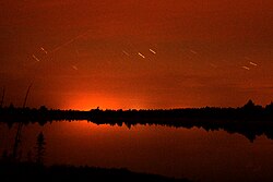
Perseid Light Trails as seen from Torrance Barrens
Canada Southern Ontario location map 2.png
Red pog.svg
Torrance Barrens
Location in southern Ontario
Location District Municipality of Muskoka, Ontario, Canada
Nearest town Gravenhurst
Coordinates 44°57′06″N79°30′11″W / 44.9517°N 79.5031°W / 44.9517; -79.5031 [1] Coordinates: 44°57′06″N79°30′11″W / 44.9517°N 79.5031°W / 44.9517; -79.5031 [1]
Area1,906 ha (7.36 sq mi) [2]
Elevation248 m (814 ft)
DesignatedJune 1997 (1997-06)
Named for Torrance, Ontario

The Torrance Barrens (officially Torrance Barrens Conservation Reserve) is a conservation area and dark-sky preserve in the District Municipality of Muskoka in Central Ontario, Canada. [1] The reserve consists of Crown Lands in the municipalities of Gravenhurst and Muskoka Lakes. It is notable as the first dark-sky preserve in Canada and for its geological and environmental features.

Contents

History

In 1870, the Musquash Colonization Road was built, connecting Gravenhurst to Musquash Falls (now Bala). This road was the first in the area and some segments are still in use. However, the portion that bisects through the reserve is no longer in use and is a separate nature reserve, the 195 acres (79 ha) Musquash Road Nature Reserve. [2] [3]

In 1992, its significant natural values were identified, and additional studies described the aesthetic and recreational importance. In 1995, the Ministry of Natural Resources proposed to protect the area and public consultations began. [2]

The reserve was established in June 1997 under Ontario Regulation 259/97, and as a result of its favourable conditions for astronomy viewing, it was recognized as a permanent dark-sky preserve in 1999, the first in Canada. [2] [4]

Geology

Pond at the Torrance Barrens Pond at the Torrance Barrens Conservation Area in 2008.jpg
Pond at the Torrance Barrens

The reserve straddles the edges of the Moon River Domain (Parry Sound Terrane) and the Go Home Domain (Algonquin Terrane), structural subdivisions of the Grenville province of the Grenville orogeny. It is characterized by low elongated ridges of Precambrian bedrock with little topsoil and scattered boulders. The ridges are granitic gneisses and migmatites of varied origins, separated by wetland, ponds, and peat-filled hollows. [2] [5]

The geology represents the Grenville Province continental accretion theme and is therefore locally significant. [2]

Environment

While the Torrance Barrens are part of an intermittent band of granite barrens stretching from Eastern Ontario to Georgian Bay, it is rare this far south in Ontario, and therefore the environment and flora of the reserve are unique and distinct in its location. [2]

Flora

The vegetation can be divided into three types: acidic rock barrens, wetlands, and upland forests. The barrens have herbaceous shrubs and graminoid heaths, with pockets of white and red pine, white and red oak, aspen and birch. The wetland consists of swamps, fen, and marshes with graminoid shrubs and peat, as well as mixed hardwood and coniferous trees. The upland forests are characterized by mature mixed coniferous and deciduous trees. In all, 463 native vascular plant species have been identified in Torrance Barrens. This includes twelve Atlantic coastal plain species which are found in Canada in only two areas and are 500 to 1,000 kilometres (310 to 620 mi) from their home ranges. [2]

Of the 463 species, 5 are rare and threatened: lance-leaved grapefern ( Botrychium lanceolatum), panic grass ( Panicum spretum), southern twayblade ( Listera australis ), white-fringed orchid ( Platanthera blephariglottis ), and halberd-leaved tearthumb ( Polygonum arifolium). [2]

Of the 12 Atlantic coastal plain species, there are 4 rare and threatened species: snail-seed pondweed ( Potamogeton bicupulatus), Carolina yellow-eyed grass ( Xyris difformis ), marsh St. John’s wort ( Triadenum virginicum) and Virginia meadow-beauty ( Rhexia virginica ). [2]

Fauna

Smooth green snake (Opheodrys vernalis) at Torrance Barrens Smooth green snake, Opheodrys vernalis, Torrance Barrens, Muskoka.jpg
Smooth green snake ( Opheodrys vernalis ) at Torrance Barrens

94 bird species, 19 mammal species, 28 butterfly species, 8 dragonfly species, and 18 reptile/amphibian species have been identified in the reserve. [2]

Of the 18 reptile/amphibian species present, 2 are of special concern: five-lined skink ( Eumeces fasciatus – Ontario's only lizard [5] ) and eastern ribbonsnake ( Thamnophis saurita ); and 3 are threatened: eastern Massasauga rattlesnake ( Sistrurus catenatus catenatus ), eastern hognose snake ( Heterodon platirhinos ) and Blanding’s turtle ( Emydoidea blandingii ). [2]

The eastern bluebird and Cooper's hawk, both rare in Canada, can be found at Torrance Barrens. [5]

Dark-sky preserve

The location and topography make the Torrance Barrens a suitable location for night-time sky viewing opportunities. There is no light pollution of nearby cities, and the reserve is mostly surrounded by undeveloped private lands and other parks, allowing it to retain the natural darkness of the night. Because of its barren bedrock, telescopes and cameras can be stationed on a solid base, immune to vibrations. Furthermore, the natural open spaces and lack of surrounding high hills provide an unobstructed panorama of the sky and horizon. [6]

Owing to these favourable conditions, the Andromeda Galaxy is visible with the naked eye from the Torrance Barrens, and with a simple telescope, the cloud bands of Jupiter and the rings of Saturn can be seen. [6]

Related Research Articles

<span class="mw-page-title-main">Point Pelee National Park</span> National park of Canada in Ontario

Point Pelee National Park is a national park in Essex County in southwestern Ontario, Canada where it extends into Lake Erie. The word pelée is French for 'bald'. Point Pelee consists of a peninsula of land, mainly of marsh and woodland habitats, that tapers to a sharp point as it extends into Lake Erie. Middle Island, also part of Point Pelee National Park, was acquired in 2000 and is just north of the Canada–United States border in Lake Erie. Point Pelee is the southernmost point of mainland Canada, and is located on a foundation of glacial sand, silt and gravel that bites into Lake Erie. This spit of land is slightly more than seven kilometres long by 4.5 kilometres (2.8 mi) wide at its northern base. Established in 1918, Point Pelee was the first national park in Canada to be established for conservation. It was designated as a Ramsar site on 27 May 1987.

<span class="mw-page-title-main">Thousand Islands – Frontenac Arch</span> Geologic region in North America

The Thousand Islands – Frontenac Arch region or the Frontenac Axis is an exposed strip of Precambrian rock in Canada and the United States that links the Canadian Shield from Algonquin Park with the Adirondack Mountain region in New York, an extension of the Laurentian mountains of Québec. The Algonquin to Adirondacks region, which includes the Frontenac Axis or Arch, is a critical linkage for biodiversity and resilience, and one with important conservation potential. The axis separates the St. Lawrence Lowlands and the Great Lakes Lowlands. It has many distinctive plant and animal species. It is one of four ecoregions of the Mixedwood Plains.

<span class="mw-page-title-main">Gravenhurst, Ontario</span> Town in Ontario, Canada

Gravenhurst is a town in the Muskoka Region of Ontario, Canada. It is located approximately 15 kilometres (9.3 mi) south of Bracebridge, Ontario. Mayor Paul Kelly was acclaimed on July 27, 2018. The Town of Gravenhurst includes a large area of the District of Muskoka, known to Ontarians as "cottage country." The town centre borders on two lakes: Lake Muskoka, which is the largest lake in the region, and Gull Lake, a smaller cottage-bordered lake. Another lake, Kahshe Lake, is situated 10 kilometres (6.2 mi) south of the town.

<span class="mw-page-title-main">Alvar</span> Limestone-based biological environment

An alvar is a biological environment based on a limestone plain with thin or no soil and, as a result, sparse grassland vegetation. Often flooded in the spring, and affected by drought in midsummer, alvars support a distinctive group of prairie-like plants. Most alvars occur either in northern Europe or around the Great Lakes in North America. This stressed habitat supports a community of rare plants and animals, including species more commonly found on prairie grasslands. Lichen and mosses are common species. Trees and bushes are absent or severely stunted.

<span class="mw-page-title-main">District Municipality of Muskoka</span> Regional municipality in Ontario, Canada

The District Municipality of Muskoka, more generally referred to as the District of Muskoka or Muskoka, is a regional municipality in Central Ontario, Canada. Muskoka extends from Georgian Bay in the west, to the northern tip of Lake Couchiching in the south, to the western border of Algonquin Provincial Park in the east. A two-hour drive north of Toronto, Muskoka spans 6,475 km2 (2,500 sq mi). Muskoka has some 1,600 lakes, making it a popular cottaging destination.

<span class="mw-page-title-main">Muskoka Lakes</span> Township in Ontario, Canada

The Township of Muskoka Lakes is a municipality of the District Municipality of Muskoka, Ontario, Canada. It has a year-round population of 6,588.

<span class="mw-page-title-main">Mississippi River (Ontario)</span> Tributary of the Ottawa River in Ontario, Canada

The Mississippi River is a tributary of the Ottawa River in Eastern Ontario, Canada which has no relation with the Mississippi River in the United States. It is 200 kilometres (120 mi) in length from its source at Mackavoy Lake, has a drainage area of 4,450 square kilometres (1,720 sq mi), and has a mean discharge of 40 cubic metres per second (1,400 cu ft/s). There are more than 250 lakes in the watershed.

<span class="mw-page-title-main">Lanark County</span> County in Ontario, Canada

Lanark County is a county located in the Canadian province of Ontario. Its county seat is Perth, which was first settled in 1816.

<span class="mw-page-title-main">Moon River (Ontario)</span> River in Ontario, Canada

The Moon River is a river in the municipalities of Georgian Bay and Muskoka Lakes, District Municipality of Muskoka in Central Ontario, Canada. It flows from Lake Muskoka at the community of Bala to Georgian Bay, Lake Huron, south of Parry Sound. The name of the river is thought to be derived from its Ojibwa name moonz-ziibi, which means "moose river".

<span class="mw-page-title-main">Massasauga</span> Species of snake (rattlesnake; Sistrurus catenatus)

The eastern massasauga is a rattlesnake species found in central and eastern North America from southern Ontario in Canada and throughout the Midwestern and Eastern United States. Like all rattlesnakes, it is a pit viper and is venomous.

Rome Sand Plains is a 15,000-acre (61 km2) pine barrens about five miles (8.0 km) west of the city center of Rome in Oneida County in central New York. It consists of a mosaic of sand dunes rising about 50 feet (15 m) above low peat bogs that lie between the dunes. The barrens are covered with mixed northern hardwood forests, meadows, and wetlands. About 4,000 acres (16 km2) are protected in conservation preserves. Pine barrens are typical of seacoasts; the Rome Sand Plains is one of only a handful of inland pine barrens remaining in the United States. A second inland pine barrens, the Albany Pine Bush, is also found in New York, located north and west of state's capital Albany.

<span class="mw-page-title-main">Queen Elizabeth II Wildlands Provincial Park</span> Provincial park in Ontario

The Queen Elizabeth II Wildlands Provincial Park is a provincial park in south-central Ontario, Canada, between Gravenhurst and Minden. The park, named for Elizabeth II, who at the time was Queen of Canada, is 33,505 hectares in size, making it the second largest park south of Algonquin Park, but it has a fragmented shape as a result of many private lands within its boundary.

<span class="mw-page-title-main">Dark-sky preserve</span> Area that restricts artificial light pollution

A dark-sky preserve (DSP) is an area, usually surrounding a park or observatory, that restricts artificial light pollution. The purpose of the dark-sky movement is generally to promote astronomy. However, astronomy is not the only objective of conserving a dark sky. A dark night sky is associated with many facets of history, philosophy, religion, societal development, poetry, song, mathematics, and science. Different terms have been used to describe the areas as national organizations have worked independently to create their programs. The International Dark-Sky Association (IDA) uses International Dark Sky Reserve (IDSR) and International Dark Sky Park (IDSP). A third designation, International Dark Sky Sanctuary, was introduced in 2015.

<span class="mw-page-title-main">Beausoleil Island</span>

Beausoleil Island; Île Beausoleil; is an 8-kilometre (5.0 mi) long island in the municipality of Georgian Bay, District Municipality of Muskoka in Central Ontario, Canada. The island is named after Louis Beausoleil, a Métis settler whose 1819 homestead stood at the island's southern tip. The name of the island in the Huron-Wendat language is Skiondechiara which means "The land to appear floating afar". The name of the island in the Anishinaabemowin language is variously Pamedenagog, Baamidoonegog or Epenmindaagoog meaning “rocky place floating about the mouth of a river”. Located in the Thirty Thousand Islands in Georgian Bay on Lake Huron, it is the largest island in Georgian Bay Islands National Park and is the only place in the park where camping is allowed. Beausoleil Island is also part of the Georgian Bay Littoral UNESCO Biosphere reserve.

Matchedash Bay is a bay and Ramsar wetland in Simcoe County in Central Ontario, Canada. It is the "final inland extension of Severn Sound" on Lake Huron's Georgian Bay, and is "situated at the interface between the Saint Lawrence Lowlands and the Canadian Shield ". It exhibits geologically unique features at the junction of the Canadian Shield and southern Ontario limestone. Wetland habitats in Matchedash Bay are varied, and include swamps, fens, cattail marshes, wet meadows and beaver ponds. Other features include "permanent freshwater lakes; upland hardwood forest, agricultural lands, native grass meadows and a unique, coniferous wetland forest".

King's Highway 169, commonly referred to as Highway 169, was a provincially maintained highway in the Canadian province of Ontario. The highway connected Highway 12 at Brechin, southeast of Orillia, with Highway 69 at Foot's Bay. The 91.40 km (56.79 mi) route included an 18.20 km (11.31 mi) concurrency with Highway 11 between Washago and Gravenhurst. Located within Simcoe County and the District Municipality of Muskoka, the highway also provided access to the community of Bala.

<span class="mw-page-title-main">Boreal forest of Canada</span> Canadian biome characterized by coniferous forests

Canada's boreal forest is a vast region comprising about one third of the circumpolar boreal forest that rings the Northern Hemisphere, mostly north of the 50th parallel. Other countries with boreal forest include Russia, which contains the majority; the United States in its northernmost state of Alaska; and the Scandinavian or Northern European countries. In Europe, the entire boreal forest is referred to as taiga, not just the northern fringe where it thins out near the tree line. The boreal region in Canada covers almost 60% of the country's land area. The Canadian boreal region spans the landscape from the most easterly part of the province of Newfoundland and Labrador to the border between the far northern Yukon and Alaska. The area is dominated by coniferous forests, particularly spruce, interspersed with vast wetlands, mostly bogs and fens. The boreal region of Canada includes eight ecozones. While the biodiversity of regions varies, each ecozone has a characteristic native flora and fauna.

Grayson Glades Natural Area Preserve is a 31-acre (13 ha) Natural Area Preserve located in Grayson County, Virginia. Its centerpiece is an extremely rare wetland type known as a "mafic fen", which are situated upon soils rich in magnesium and fed by springs. The site is at the headwaters of a small stream system supporting additional mafic fens.

Located in the southern part of British Columbia, Columbia National Wildlife Area was established to protect its wetlands and as a temporary home for migratory birds travelling to South America. The National Wildlife Area (NWA) is divided into four unit areas: Wilmer, Spillimacheen, Brisco and Harrogate, which are home to many diverse species of animals and plants which are significant in Canada.

<span class="mw-page-title-main">Carp Hills</span> Landform in Ottawa, Ontario, Canada

The Carp Hills are a small range of rocky hills between the shallow valleys of the Carp River and Constance Creek, entirely within the West Carleton-March Ward of Canada's capital, Ottawa, Ontario. It runs roughly from Kinburn Side Road southeast to the village of Carp and the South March Highlands at March Road.

References

  1. 1 2 3 "Torrance Barrens Conservation Reserve". Geographical Names Data Base . Natural Resources Canada . Retrieved July 7, 2018.
  2. 1 2 3 4 5 6 7 8 9 10 11 12 "Torrance Barrens Conservation Reserve (Dark Sky Reserve) Statement of Conservation Interest" (PDF). Ministry of Natural Resources – Parry Sound District. February 2006. Archived (PDF) from the original on June 16, 2016. Retrieved July 18, 2018.{{cite journal}}: Cite journal requires |journal= (help)
  3. "Musquash Road Nature Reserve". muskokaconservancy.org. Muskoka Conservancy. Archived from the original on July 18, 2018. Retrieved July 18, 2018.
  4. Peter McMahon (April 4, 2011). "Preserving the night sky: Dark-sky preserves in Canada". Canadian Geographic. Royal Canadian Geographical Society. Archived from the original on July 16, 2018. Retrieved July 18, 2018.
  5. 1 2 3 "Torrance Barrens Hiking Trails". www.discovermuskoka.ca. Muskoka Tourism. Archived from the original on January 22, 2018. Retrieved July 18, 2018.
  6. 1 2 Michael Silver (May 3, 2011). "Torrance Barrens Dark-Sky Preserve". www.rasc.ca. The Royal Astronomical Society of Canada. Archived from the original on July 17, 2018. Retrieved July 17, 2018.