Kahramanmaraş Province is a province of Turkey. Its provincial capital is the city of Kahramanmaraş, the traffic code is 46.

Shuswap Lake is a lake located in the southern interior of British Columbia, Canada that drains via the Little Shuswap River into Little Shuswap Lake. Little Shuswap Lake is the source of the South Thompson River, a branch of the Thompson River, a tributary of the Fraser River. It is at the heart of a region known as the Columbia Shuswap or "the Shuswap", noted for its recreational lakeshore communities including the city of Salmon Arm. The name "Shuswap" is derived from the Shuswap or Secwepemc First Nations people, the most northern of the Interior Salish peoples, whose territory includes the Shuswap. The Shuswap call themselves /ʃǝxwépmǝx/ in their own language, which is called /ʃǝxwepmǝxtʃín/, but the ethnonym's original meaning is now lost.

The City of Enderby is in the North Okanagan region of the Canadian province of British Columbia, between Armstrong and Salmon Arm. It is approximately 80 km north of Kelowna and 130 km east of Kamloops. Highway 97A passes through Enderby and the Shuswap River marks the eastern and northeastern limits of the City. There are two major schools in Enderby: M.V. Beattie Elementary School and A.L. Fortune Secondary School. M.V. Beattie Elementary School was rebuilt in 2012.

Bragg Creek Provincial Park is a Canadian provincial park in Alberta's Rocky Mountains at the eastern edge of Kananaskis Country. This park is located near the Elbow River and includes facilities for picnicking, hiking, and fishing.

Petroglyph Provincial Park is a provincial park located at the south end of the city of Nanaimo in British Columbia, Canada. The park was established on August 24, 1948 to protect a collection of petroglyphs found near the estuary of the Nanaimo River.
John Andrew Mara was a Canadian merchant, rancher and a politician at both the provincial and federal levels.

Bear Creek Provincial Park is a provincial park in British Columbia, Canada. It is situated on the west side of the Okanagan Lake and is northwest of the city of Kelowna. It was established on April 19, 1981, and was expanded to its current size of 178 hectares on May 12, 1988.
Blackcomb Glacier Provincial Park is a provincial park in British Columbia, Canada, located just east of and above the resort town of Whistler and adjacent to Garibaldi Provincial Park. The park was established in 1990 on land formerly protected by Garibaldi Park.
Kekuli Bay Provincial Park, formerly Kalamalka West Provincial Park, is a provincial park in British Columbia, Canada, located on the west shore of Kalamalka Lake on BC Highway 97 south of Vernon. The lake is popular for waterskiing and boating, and the park includes a boat launch, as well as a campground with a view of the lake. The park was established in 1990. Its size is about 57 hectares.

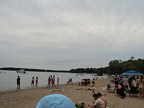
Mara Provincial Park is a day-use provincial park in British Columbia, Canada, located on Mara Lake south of Sicamous. The park is open with services from May 1 to September 27. The gate is locked open during the off season.
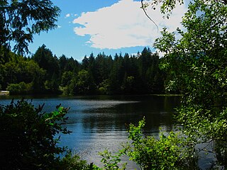
Murrin Provincial Park is a provincial park in British Columbia, Canada, located just south of Squamish beside the Sea-to-Sky Highway. The park is approximately 24 ha. in size and has a popular highway-side picnic ground and small swimming lake, but it is most notable for a collection of petroglyphs located away from the highway and accessed by trail. Several rockfaces in the area of the park are popular with the local mountain-climbing community, though the site is nowhere as busy as the nearby Stawamus Chief.

Otter Lake Provincial Park is a provincial park in British Columbia, Canada. It is located near the towns of Coalmont and Princeton. The park is open all year for day use and open May 15 - September 28 for overnight camping.
Shuswap Lake Marine Provincial Park is an 896-hectare provincial park in British Columbia, Canada, comprising 991 ha. The Park has a variety of amenities including boat launch ramps, picnic areas, and 27 campsites around the perimeter of Shuswap Lake. The lake's name and that of the surrounding Shuswap Country is from the Shuswap people (Secwepemc), the most northern of the Salishan speaking people.

Silver Star Provincial Park is a Class C provincial park in British Columbia, Canada, located northeast of the city of Vernon in the Shuswap Highland of the Monashee Mountains.

Trepanier Provincial Park is a provincial park in British Columbia, Canada. This 2,884 hectare park is roughly 24 km west of Kelowna.
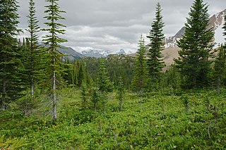
The Montane Cordillera Ecozone, as defined by the Commission for Environmental Cooperation (CEC), is an ecozone in south-central British Columbia and southwestern Alberta, Canada. A rugged and mountainous ecozone spanning 473,000 square kilometres, it still contains "two of the few significant agricultural areas of the province", the Creston Valley and the Okanagan Valley. Primarily a mountainous region, it consists of rugged ecosystems such as alpine tundra, dry sagebrush and dense conifer forests. The interior plains are encircled by a ring of mountains. The area has a mild climate throughout the year, with typically dry summers and wet winters.

Mara Lake is a lake in the Shuswap Country of the Southern Interior of British Columbia, Canada, located immediately south of the community of Sicamous and to the north of the community of Enderby. It is the outlet of the Shuswap River, which begins in the Monashee Mountains to the east. Its own outlet is Sicamous Narrows, which is a short canal-like stretch of water connecting to Shuswap Lake and passing beneath the Trans-Canada Highway and the Canadian Pacific Railway mainline at Sicamous. All are part of the drainage of the South Thompson River, which begins at the outlet of Little Shuswap Lake.
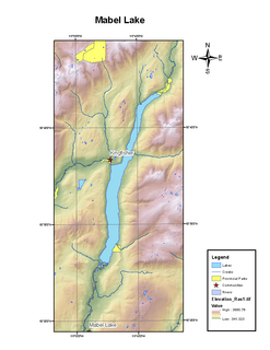
Mabel Lake is a lake located in southern Interior British Columbia, Canada, that is fed by and drained by the Shuswap River. It is located southeast of Shuswap Lake, northeast of Okanagan Lake, and west of the Monashee Mountains, and is popular for camping and fishing. The area around the lake is mountainous and sparsely populated.