Oshawa is a city in Ontario, Canada, on the Lake Ontario shoreline. It lies in Southern Ontario, approximately 60 km (37 mi) east of Downtown Toronto. It is commonly viewed as the eastern anchor of the Greater Toronto Area and of the Golden Horseshoe. It is the largest municipality in the Regional Municipality of Durham. The name Oshawa originates from the Ojibwa term aazhawe, meaning "the crossing place" or just "a cross".

Clarington is a lower-tier municipality in the Regional Municipality of Durham in Ontario, Canada. It was incorporated in 1973 as the town of Newcastle with the merging of the town of Bowmanville, the Village of Newcastle and the townships of Clarke and Darlington, and was established on January 1 1974. In 1993, the town was renamed Clarington, a portmanteau of the names of the two former townships. Bowmanville is the largest community in the municipality and is the home of the municipal offices.

Long Point is a sand spit and medium-sized hamlet on the north shore of Lake Erie, part of Norfolk County in the province of Ontario, Canada.

The Regional Municipality of Durham, informally referred to as Durham Region, is a regional municipality in Southern Ontario, Canada. Located east of Toronto and the Regional Municipality of York, Durham forms the east-end of the Greater Toronto Area and part of the Golden Horseshoe region. It has an area of approximately 2,500 km2 (970 sq mi). The regional government is headquartered in Whitby.

Prince Edward County (PEC) is a municipality in southern Ontario, Canada. Its coastline on Lake Ontario’s northeastern shore is known for Sandbanks Provincial Park, sand beaches, and limestone cliffs. The Regent Theatre, a restored Edwardian opera house, sits at the heart of the town of Picton on the Bay of Quinte. Nearby Macaulay Heritage Park highlights local history through its 19th-century buildings. In 2016, Prince Edward County had a census population of 24,735. Prince Edward County is a city, single-tier municipality and a census division of the Canadian province of Ontario.
Bowmanville is a town of approximately 40,000 people located in the Municipality of Clarington, Durham Region, Ontario, Canada. It is approximately 75 km (47 mi) east of Toronto, and 15 km (9.3 mi) east of Oshawa along Highway 2. Bowmanville was first incorporated as a town in 1858, but later incorporated with the neighbouring townships of Clarke and Darlington in 1974 forming the Town of Newcastle, which was renamed in 1994 to the Municipality of Clarington. Bowmanville is part of the Greater Toronto Area.

Presqu'ile Provincial Park is a park in southeastern Northumberland County on the north shore of Lake Ontario near the town of Brighton in Ontario, Canada. The park occupies an area of 9.37 km2 (3.62 sq mi). The name of the park is the French word for peninsula, or literally "almost island", and was believed to be named by Samuel De Champlain on his second expedition. The peninsula was formed when a limestone island was connected to the mainland by a sand spit; this kind of formation is referred to as a tombolo.

Courtice is a community in Ontario, Canada, about 60 km (37 mi) east of Toronto, within the Municipality of Clarington. Adjacent to Oshawa, it is west of Bowmanville, which is also part of Clarington. Courtice Road connects with Highway 401 at Interchange 425, providing arterial access to the community. Darlington Provincial Park is located just south of Courtice.

Sleeping Giant Provincial Park, established in 1944 as Sibley Provincial Park and renamed in 1988, is a 244-square-kilometre (94 sq mi) park located on the Sibley Peninsula in Northwestern Ontario, east of Thunder Bay. The nearest communities are Pass Lake, in the township of Sibley, located at the northern entrance to the park, and Dorion, located 35 kilometres (22 mi) NW, in the township of Shuniah. The seasonal community of Silver Islet is located on the southern tip of the peninsula. The primary feature of the park is the Sleeping Giant, which is most visible from the city of Thunder Bay.

The North Shore of Lake Superior runs from Duluth, Minnesota, United States, at the western end of the lake, to Thunder Bay and Nipigon, Ontario, Canada, in the north, to Sault Ste. Marie, Ontario in the east. The shore is characterized by alternating rocky cliffs and cobblestone beaches, with forested hills and ridges through which scenic rivers and waterfalls descend as they flow to Lake Superior.

Long Point Provincial Park is a provincial park on the northwest shore of Lake Erie near Port Rowan, Ontario, Canada. The park is part of a sandy spit of land called Long Point that juts out into the lake. It covers part of the area of Long Point Biosphere Reserve, which was designated a UNESCO Biosphere Reserve because of its biological significance.

Carrying Place is a community straddling the Quinte West and Prince Edward County border that serves as a gateway to Prince Edward County, Ontario, Canada. Situated northwest of Picton and just south of Trenton, it was named for its location on the portage between the Bay of Quinte and Weller's Bay on Lake Ontario. The Loyalist Parkway passes through the community.

Bowmanville Zoo was a zoo in Clarington, Ontario, Canada. Founded in 1919, at the time of its closure, in 2016, it was the oldest private zoo in North America. It was a large supplier of animals to the U.S. film industry.
James Wellington McLaughlin was an Ontario doctor and political figure. He represented Durham West in the Legislative Assembly of Ontario as a Liberal from 1879 to 1890.
Opasquia Provincial Park is a provincial park located in northwest Ontario, Canada. Situated alongside the Manitoba border, this remote park is approximately 473,000 hectares in size. The Opasquia park is home to many different species of plants and animals.

The Almaguin Highlands Region in Ontario, Canada, covers approximately 5,200 km2 (2,000 sq mi) comprising the eastern half of Parry Sound District. It is bounded by Muskoka in the south, and by Lake Nipissing and Nipissing District in the north. The eastern edge abuts the western boundary of Algonquin Provincial Park, whereas the western boundary of the Almaguin Highlands is generally regarded to be the mid east-west point of Parry Sound District. Originally derived from the words, Algonquin, Magnetawan, and Seguin. Almaguin is now used to describe the marketing region of East Parry Sound.
Tyrone is a community in Ontario, Canada, incorporated in the municipality of Clarington. It was named after County Tyrone in Ireland. Tyrone is located about 12 km north of the town of Bowmanville.

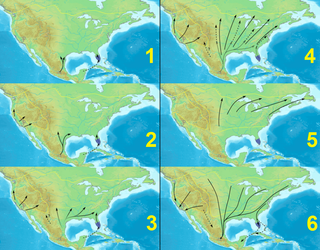
Monarch butterfly migration is the phenomenon, mainly across North America, where the subspecies Danaus plexippus plexippus migrates each summer and autumn to and from overwintering sites on the West Coast of California or mountainous sites in Central Mexico. Other subspecies perform minor migrations or none at all. This massive movement of butterflies has been called "one of the most spectacular natural phenomena in the world".
Gravel River Provincial Park is a nature reserve in the Thunder Bay District of Ontario, Canada. It protects an unusual birds-foot delta at the mouth of the Gravel River.
John R. Park Homestead Conservation Area is the original home of John and Amelia (Gamble) Park. It is now an agricultural and living history museum of farm life in the 19th century in present-day Essex, Ontario.


