
Karst is a topography formed from the dissolution of soluble carbonate rocks such as limestone, dolomite, and gypsum. It is characterized by features like poljes above and drainage systems with sinkholes and caves underground. It has also been documented for more weathering-resistant rocks, such as quartzite, given the right conditions. Subterranean drainage may limit surface water, with few to no rivers or lakes. In regions where the dissolved bedrock is covered or confined by one or more superimposed non-soluble rock strata, distinctive karst features may occur only at subsurface levels and can be totally missing above ground.

A sinkhole is a depression or hole in the ground caused by some form of collapse of the surface layer. The term is sometimes used to refer to doline, enclosed depressions that are locally also known as vrtače and shakeholes, and to openings where surface water enters into underground passages known as ponor, swallow hole or swallet. A cenote is a type of sinkhole that exposes groundwater underneath. Sink and stream sink are more general terms for sites that drain surface water, possibly by infiltration into sediment or crumbled rock.
The Highland Rim is a geographic term for the area in Tennessee surrounding the Central Basin. Nashville is largely surrounded by higher terrain in all directions.

A cenote is a natural pit, or sinkhole, resulting from the collapse of limestone bedrock that exposes groundwater. The term originated on the Yucatán Peninsula of Mexico, where cenotes were commonly used for water supplies by the ancient Maya, and occasionally for sacrificial offerings. The term derives from a word used by the lowland Yucatec Maya—tsʼonoʼot—to refer to any location with accessible groundwater.

Carboniferous Limestone is a collective term for the succession of limestones occurring widely throughout Great Britain and Ireland that were deposited during the Dinantian Epoch of the Carboniferous Period. These rocks formed between 363 and 325 million years ago. Within England and Wales, the entire limestone succession, which includes subordinate mudstones and some thin sandstones, is known as the Carboniferous Limestone Supergroup.

The Altopiano delle Murge is a karst topographic plateau of rectangular shape in southern Italy. Most of it lies within Apulia and corresponds with the sub-region known as Murgia or Le Murge. The plateau lies mainly in the Metropolitan City of Bari and the province of Barletta-Andria-Trani, but extends into the provinces of Brindisi and Taranto to the south, and into Matera in Basilicata to the west. The name is believed to originate from the Latin murex, meaning "sharp stone".

The Twenty Mile Creek is a minor waterway, located in the Niagara Peninsula, Ontario, Canada. The creek is named for the location of its mouth, twenty miles (32 km) west of the Niagara River along the Lake Ontario shoreline. The Indigenous name for the Twenty Mile Creek was the Kenachdaw, which translates to Lead River.
An Area of Natural and Scientific Interest is an official designation by the provincial Government of Ontario in Canada applied to contiguous geographical regions within the province that have geological or ecological features which are significantly representative provincially, regionally, or locally. Some sites with this designation were assessed through the International Biological Program between 1964 and 1974. As of 2014, over 1000 sites covering 460,000 hectares (4,600 km2) have been designated in the province.

Paul David Miller is a politician in Ontario, Canada. He was a member of the Legislative Assembly of Ontario from 2007 provincial election until his defeat in the 2022 Ontario general election.

A ponor is a natural opening where surface water enters into underground passages; they may be found in karst landscapes where the geology and the geomorphology is typically dominated by porous limestone rock. Ponors can drain stream or lake water continuously or can at times work as springs, similar to estavelles. Morphologically, ponors come in forms of large pits and caves, large fissures and caverns, networks of smaller cracks, and sedimentary, alluvial drains.
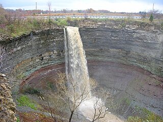
Devil's Punch Bowl is a 37-metre ribbon waterfall on the Niagara Escarpment, in the Stoney Creek community of Hamilton, Ontario, Canada. It is found in the Devil's Punchbowl Conservation Area, maintained by the Hamilton Conservation Authority, and features an escarpment access trail with connections to a recently improved section of the Bruce Trail. Stoney Creek's Dofasco 2000 Trail is nearby. The Punch Bowl is also known as Horseshoe Falls for the distinctive shape of the cliff-face, which somewhat resembles its much larger cousin in Niagara Falls.
The Nambung River is a river in the Wheatbelt region of Western Australia, 170 kilometres (106 mi) north of Perth. The river drains an area between the towns of Cervantes and Badgingarra. In its lower reaches the Nambung River forms a chain of waterholes in the Nambung Wetlands where it disappears underground into a limestone karst system 5.5 kilometres (3 mi) from the Indian Ocean.
The Caves of the Tullybrack and Belmore hills are a collection of caves in southwest County Fermanagh, Northern Ireland. The region is also described as the West Fermanagh Scarplands by environmental agencies and shares many similar karst features with the nearby Marble Arch Caves Global Geopark.

Suffosion is one of the two geological processes by which subsidence sinkholes or dolines are formed, the other being due to collapse of an underlying cave or void, with most sinkholes formed by the suffosion process. Suffosion sinkholes are normally associated with karst topography although they may form in other types of rock including chalk, gypsum and basalt. In the karst of the UK's Yorkshire Dales, numerous surface depressions known locally as "shakeholes" are the result of glacial till washing into fissures in the underlying limestone.

Uvala is originally a local toponym used by people in some regions in Slovenia, Croatia, Bosnia and Herzegovina, Montenegro and Serbia. In geosciences it denotes a closed karst depression, a terrain form usually of elongated or compound structure and of larger size than that of sinkholes. It is a morphological form frequently found in the outer Dinaric Alps anywhere between Slovenia and Greece, but large closed karst depressions are found on all continents in different landscapes and therefore uvala has become a globally established term. It is also used to distinguish such depressions from poljes, which are many square kilometres in size. Definitions of uvalas are often poorly empirically supported. "The coalescence of dolines" (sinkholes) is the dominant and most frequently found definition. However, because of the ongoing dissatisfaction with this definition, the term 'uvala' has often been belittled – occasionally it was even proposed that the term be given up altogether.
Tapir Mountain Nature Reserve is a protected area in Belize, Central America. It falls under category (Ia) of the International Union for Conservation of Nature protected areas categories. It is managed by the Belize Forest Department and co-managed by the Belize Karst Habitat Conservation.
Cedar Sink is a vertical-walled large depression, or sinkhole, in the ground, that is located in Edmonson County, Kentucky and contained within and managed by Mammoth Cave National Park. The sinkhole measures 300 feet (91.4 m) from the top sandstone plateau to the bottom of the sink and was caused by collapse of the surface soil. The landscape is karst topography, which means the region is influenced by the dissolution of soluble rocks. Sinkholes, caves, and dolines typically characterize these underground drainage systems. Cedar Sink has a bottom area of about 7 acres (2.8 ha) and has more fertile soil compared to the ridgetops.


