The Niagara Escarpment is a long escarpment, or cuesta, in the United States and Canada that runs predominantly east–west from New York through Ontario, Michigan, Wisconsin, and Illinois. The escarpment is most famous as the cliff over which the Niagara River plunges at Niagara Falls, for which it is named.

The Humber River is a river in Southern Ontario, Canada. It is in the Great Lakes Basin, is a tributary of Lake Ontario and is one of two major rivers on either side of the city of Toronto, the other being the Don River to the east. It was designated a Canadian Heritage River on September 24, 1999.

Halton Hills is a town in the Regional Municipality of Halton, located in the northwestern end of the Greater Toronto Area, Ontario, Canada with a population of 61,161 (2016).

Erin is a town in Wellington County, approximately 80 kilometres (50 mi) northwest of Toronto, Ontario, Canada. Erin is bordered by the Town of Caledon, Ontario to the east, the Town of Halton Hills to the south, the Township of Guelph/Eramosa to the west and the Township of East Garafraxa to the north.

The Genesee River is a tributary of Lake Ontario flowing northward through the Twin Tiers of Pennsylvania and New York in the United States.

Queenston is a compact rural community and unincorporated place 5 kilometres (3.1 mi) north of Niagara Falls in the Town of Niagara-on-the-Lake, Ontario, Canada. It is bordered by Highway 405 to the south and the Niagara River to the east; its location at the eponymous Queenston Heights on the Niagara Escarpment led to the establishment of the Queenston Quarry in the area. Across the river and the Canada–US border is the village of Lewiston, New York. The Lewiston-Queenston Bridge links the two communities. This village is at the point where the Niagara River began eroding the Niagara Escarpment. During the ensuing 12,000 years the Falls cut an 11 kilometres (6.8 mi) long gorge in the Escarpment southward to its present-day position.

Waterdown is a community in Canada which since 2001 has been a community of Hamilton, Ontario. Waterdown is approximately 60 km west of downtown Toronto.

The Credit River is a river in southern Ontario, which flows from headwaters above the Niagara Escarpment near Orangeville and Caledon East to empty into Lake Ontario at Port Credit, Mississauga. It drains an area of approximately 1,000 square kilometres (390 sq mi). The total length of the river and its tributary streams is over 1,500 kilometres (930 mi).
Erindale is an historical neighbourhood located within the central part of the city of Mississauga, west of Toronto, Ontario, Canada. Erindale is named in honour of the birthplace of the first rector of the village, Reverend James Magrath from Erin (Ireland).

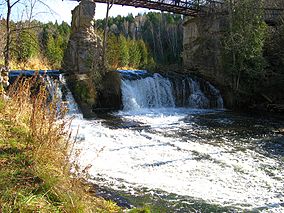
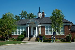
Limehouse is a community in the Town of Halton Hills in southern Ontario, Canada. It has a population of about 800 people and its closest neighbours are Georgetown and Acton. Limehouse has many hills, trails and even a small school.
Scouting and Guiding in Ontario has a long history. Although there is some dispute about the founding of the first Scouting Group, both 1st Merrickville and 1st St. Catharines Scout Group have a documented existence from 1908. In 1955, the 8th World Scout Jamboree was held at Niagara-on-the-Lake, Ontario. Scouting continues in Ontario to the present day, serving thousands of youths in programs that suit the environment in which they live.
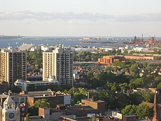
Hamilton is located on the western end of the Niagara Peninsula and wraps around the westernmost part of the Lake Ontario. Most of the city including the downtown section lies along the south shore. Situated in the geographic centre of the Golden Horseshoe, it lies roughly midway between Toronto and Buffalo. The two major physical features are Hamilton Harbour marking the northern limit of the city and the Niagara Escarpment running through the middle of the city across its entire breadth, bisecting the city into 'upper' and 'lower' parts.
The Short Hills Bench is a sub-appellation of the Niagara Peninsula.
The Twenty Mile Creek is a minor waterway, located in the Niagara Peninsula, Ontario, Canada. The creek is named for the location of its mouth, twenty miles (32 km) west of the Niagara River along the Lake Ontario shoreline. The Indian name for the Twenty Mile Creek was the Kenachdaw, which translates to Lead River.

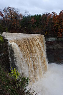
Eugenia is a small community in the municipality of Grey Highlands, Grey County, in Southwestern Ontario, Canada, located just north of the community of Flesherton. An unincorporated hamlet of Artemesia Township for most of its history, Eugenia was amalgamated into the Grey Highlands in 2001. Due to nearby Lake Eugenia, Eugenia Falls, the Bruce Trail and the ski resorts of the Beaver Valley, it has become a popular tourist and cottage destination. The nearby Eugenia Power Station has the highest head of water of any hydroelectric generator in Ontario, and has provided a significant amount of electricity to the provincial grid for a century.

Twelve Mile Creek is a waterway located on the Niagara Peninsula in the Regional Municipality of Niagara in Southern Ontario, Canada. Its headwaters are located in the town of Pelham, encompassing some of the most unspoiled and natural areas of Niagara area. The creek's lower reaches flow through urban areas of Thorold and St. Catharines, and have been heavily altered by human activity for almost two centuries. The creek was first known as "Ashquasing" by the Mississaugas Indigenous people, the name meaning "that which lies at the end" in the Anishinaabe language.

Dundas Valley Conservation Area is located on the Niagara Escarpment in Dundas, Ontario, a constituent community of Hamilton, Ontario, and is owned and operated by the Hamilton Conservation Authority. Its 40-kilometre trail system provides a connection to the Bruce Trail. The area contains a trailhead of the Hamilton-Brantford-Cambridge Trails, Canada's first fully developed interurban multi-use trail system, which is a part of the Trans Canada Trail.

The Credit Valley Railway was a railway located in Ontario, Canada from Toronto to St. Thomas. Chartered in 1871 by Ontario railway magnate George Laidlaw, it operated as an independent company until 1883 when it was leased by the Ontario and Quebec Railway, a Canadian Pacific Railway (CPR) operating company building a network of lines in southern Ontario.

The Cheltenham Badlands are in Caledon, Ontario, on the south east side of Olde Base Line Road, between Creditview and Chinguacousy Roads. The site occupies an area of approximately 0.4 square kilometers and features exposed and highly eroded Queenston shale. The Cheltenham Badlands are a significant educational site due to the readily visible geologic processes and the red colour and the unique topography of the exposed shale makes this a popular tourist site. The site is a Provincial Earth Sciences Area of Natural and Scientific Interest (ANSI) since it is considered one of the best examples of "badlands topography" in Ontario.