
Lake Ontario is one of the five Great Lakes of North America. It is bounded on the north, west, and southwest by the Canadian province of Ontario, and on the south and east by the U.S. state of New York. The Canada–United States border spans the centre of the lake.

Prince Edward Island National Park is a National Park of Canada located in the province of Prince Edward Island. Situated along the island's north shore, fronting the Gulf of St. Lawrence, the park measures approximately 60 km (37 mi) in length and ranges from several hundred metres to several kilometres in width. Established in 1937, the park's mandate includes the protection of many broad sand beaches, sand dunes and both freshwater wetlands and saltmarshes. The park's protected beaches provide nesting habitat for the endangered piping plover; the park has been designated a Canadian Important Bird Area.

Southern Ontario is a primary region of the Canadian province of Ontario. It is the most densely populated and southernmost region in Canada, with approximately 13.5 million people, approximately 36% of Canada's population of 37 million. The region lies south of the province's other primary region, Northern Ontario, although the exact northern boundary of Southern Ontario is disputed. However, its core region is situated south of Algonquin Park, the latter being in an area of transition between coniferous forest north of the French and Mattawa Rivers and southern deciduous forest. It covers between 14 and 15% of the province, depending on the inclusion of the Parry Sound and Muskoka districts which also lie in the transitional area between northern and southern forest regions. Southern Ontario differs greatly from Northern Ontario, having a much higher population density, a different climate, and a different culture than its northern counterpart. It is broken into smaller subregions, including Central Ontario, Eastern Ontario, the Golden Horseshoe, and Southwestern Ontario.

Southwick Beach State Park is a New York State park that lies along an unusual stretch of sandy beach on the eastern shore of Lake Ontario. The park is 464 acres (188 ha) in size with a 3,500 foot (1,100 m) length of beach, and is visited annually by about 100,000 people. Immediately to the south is the Lakeview Wildlife Management Area, which extends the publicly accessible beach by several miles. They are in the Town of Ellisburg in Jefferson County, New York south of the lakeside community of Jefferson Park.

Prince Edward County (PEC) is a county in southern Ontario, Canada. Its coastline on Lake Ontario’s northeastern shore is known for Sandbanks Provincial Park, sand beaches, and limestone cliffs. The Regent Theatre, a restored Edwardian Opera House, sits at the heart of the town of Picton on the Bay of Quinte. Nearby Macaulay Heritage Park highlights local history through its 19th-century buildings. In 2016, Prince Edward County had a census population of 24,735. Prince Edward County is a city, single-tier municipality and a census division of the Canadian province of Ontario.

The Batchawana River is a river in Algoma and Sudbury Districts of Ontario, Canada, which empties into Batchawana Bay on Lake Superior north of Sault Ste. Marie, Ontario.
Charles Jackson "Bud" Wildman is a Canadian politician. He served in the Legislative Assembly of Ontario as a New Democratic Party Member of Provincial Parliament (MPP) from 1975 to 1999, representing the riding of Algoma, and was a cabinet minister in the government of Bob Rae.

Presqu'ile Provincial Park is a park in southeastern Northumberland County on the north shore of Lake Ontario near the town of Brighton in Ontario, Canada. The park occupies an area of 9.37 km2 (3.62 sq mi). The name of the park is the French word for peninsula, or literally "almost island", and was believed to be named by Samuel De Champlain on his second expedition. The peninsula was formed when a limestone island was connected to the mainland by a sand spit; this kind of formation is referred to as a tombolo.

Rondeau Provincial Park is the second oldest provincial park in Ontario, Canada, having been established with an order in council on 8 September 1894. The park is located in Southwestern Ontario, on an 8 km long crescentic sand spit extending into Lake Erie. Rondeau is home to the largest area of Carolinian forest in Canada, a long sand beach, a large marsh, approximately half of Rondeau Bay, campgrounds and a cottage community. The name of the park comes from the French words "ronde eau" or "round water" which describes the shape of the harbour sheltered by the peninsula.

Quetico Provincial Park is a large wilderness park in Northwestern Ontario, Canada, known for its excellent canoeing and fishing. The 4,760 km2 (1,180,000-acre) park shares its southern border with Minnesota's Boundary Waters Canoe Area Wilderness, which is part of the larger Superior National Forest. These large wilderness parks are often collectively referred to as the Boundary Waters or the Quetico-Superior Country.

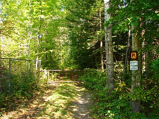
Awenda Provincial Park is a provincial park in Tiny Township, Simcoe County in Central Ontario, Canada, located on a peninsula jutting into Georgian Bay north of Penetanguishene. The park occupies an area of 2,915 hectares and was established in 1975. It is classified as a Natural Environment Park and therefore all land is protected.
The orders, decorations, and medals of the Canadian provinces, in which each province of Canada has devised a system of orders and other awards to honour residents for actions or deeds that benefit their local community or province, are in turn subsumed within the Canadian honours system. Each province sets its own rules and criteria for eligibility and also for how each award is presented. Most of the awards allow for the recipients to wear their awards in public, and most grant the recipients the use of post-nominal letters after their names. Not all of the awards listed below are part of the Canadian honours system, thus some of them may not be worn or court mounted with awards that are part of the Canadian honours system.
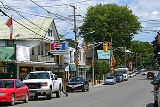
Wellington is an unincorporated place and community in Prince Edward County in eastern Ontario, Canada. It has a population of 1,932 according to the 2016 Census. The community is located on the shore of both Lake Ontario and West Lake in the southwest of the county. Sandbanks Beach, the northernmost of Sandbanks Provincial Park's beaches, is located in the Village of Wellington, where it is called Wellington Rotary Beach.

Bronte Creek Provincial Park is located in Oakville, Ontario, Canada, and is part of the Ontario Parks system.
Westmeath Provincial Park is a provincial park on the Ottawa River in Renfrew County, Ontario, Canada. Located on the section of the river known as Bellows Bay, it features a long sandy beach and an active sandspit. It is one of the most pristine sand dune and wetland complexes along the southern Ottawa River.
William Finlayson was an Ontario lawyer, cabinet minister and political figure.

Ontario is Canada's largest province in population and second largest province in size, covering close to one million square kilometres. It borders the United States to the south, and the provinces of Quebec to the east and Manitoba to the west. Around 250,000 lakes can be found in Ontario, making up approximately one-third of the world's fresh water.
Ferdinand Alphonse Fortunat Larose was a French Canadian agronomist, best known for having created in Ontario one of the largest regeneration forests in the 1920s, named after him.

Sandbanks Provincial Park is a provincial park on the island of Newfoundland in the province of Newfoundland and Labrador. It is located on the southwest coast, approximately 150 km from the Trans-Canada Highway near the town of Burgeo, less than three hours from Corner Brook. The park is known for its expansive sandy beaches and dunes.
Candle Lake Provincial Park is a provincial park in the central region of the Canadian province of Saskatchewan. Prior to the park's establishment in 1986, it was a provincial recreation site. Located in the Rural Municipality of Paddockwood No. 520, Candle Lake Provincial Park surrounds most of Candle and Torch Lakes in the boreal forest ecozone of Canada. The park has a variety of activities including camping, boating, fishing, swimming, mini golfing, hiking, and golfing. Around the lake there are also boat launches and several marinas. Natural attractions include a purple sand beach, sand dunes, mature forests, crystal clear lake water, and several natural sand beaches.


