History
1950s: Introduction
The LSRCA was established in 1951 by the Department of Planning and Development as the Upper Holland Valley Conservation Authority. It was founded by the municipalities of East Gwillimbury, Township of King, Aurora, Newmarket, and Whitchurch.
In 1954, Hurricane Hazel destroys parts of the Greater Toronto Area. The LSCRA learned from this, and now (like all other conservation authorities) issues Flood alerts, Flood warnings, and Flood bulletins to the Lake Simcoe watershed population, the media, and School Boards. The following year, the Conservation Authority subsidizes tree planting and farm pond construction on private lands.
By 1958, many members express concern due to the explosion of development in Newmarket, and how it may affect the groundwater supplies.
1959 saw many changes, as the Upper Holland Valley Conservation Authority requests the provincial government to pass legislation to control tree-cutting on private and public property. The Conservation Authority also purchases its first plot of land, the 20-acre (81,000 m2) Anchor Park in Holland Landing, Ontario.
1960s: Holland Valley Conservation Authority
When the 1960s came, the UHVCA's boundaries expanded to include the entire Holland River and Schomberg River subwatersheds. This added the communities of Bradford, West Gwillimbury, Ontario (which will eventually merge into Bradford-West Gwillimbury), and New Tecumseth, Ontario. The Holland Valley Conservation Authority secured close to 900 acres (3.6 km2) of environmentally significant lands in the 1960s including:
The Conservation Authority also distributes over 5000 copies of their own comic book, named "Dennis The Menace And Dirt", which emphasizes on soil productivity, the importance of soil conservation, and how farming depends on fertile soils. HVCA releases two separate reports in 1961 ("Conservation Report on Land and Forest"), and in 1966 ("Report on Water"). In both reports, the Authority identifies special needs and goals that need to be met, such as improving management of light soils on the Oak Ridges Moraine, encouraging private reforestation, pass regulations that prohibit construction and dumping in flood plains, and the need to fight streambank erosion.
An Emergency Flood Fund was established in 1967, and Centennial tree planting swept across the entire watershed, including reforesting the Scanlon Creek Conservation Area.
1970s: South Lake Simcoe Conservation Authority
In 1970, the Conservation Authority planned to plant 3 million trees by the year 2001. In this year, the municipalities of Scott, Ontario, and Georgina, Ontario, joined the Conservation Authority. The name of the authority changed to South Lake Simcoe Conservation Authority in 1971. In 1974, the town of Innisfil joined. The organization established a watershed-wide natural heritage network by creating the following conservation areas:
The 1973 Lake Simcoe Conservation Report was released, and the guidelines stated that the Conservation Authority would monitor and review subdivision plans for home construction, provide landowners with assistance for riverbank upgrades, and establish a flood warning system. The other main goals were to protect water recharge areas, such as marshes, and to continue protection of the Oak Ridges Moraine.
1976 saw the first annual Conservation Authority-sponsored maple syrup festival at the Sheppard's Bush Conservation Area in Aurora. The festival ("Maplefest") continues to this day, and the festival celebrating the Canadian tradition is an enduring success.
1980s: Lake Simcoe Environmental Management Strategy
The Lake Simcoe Environmental Management Strategy (LSEMS) is developed, in co-operation with the Ministries of Natural Resources, the Environment, and the Ministry of Agriculture, Food and Rural Affairs. The Conservation Authority added a number of properties to its natural heritage network in the 1980s including:
- 1980 – SLSCA begins work on identifying environmentally significant areas in the watershed.
- 1980–1993 – Tyrwhitt
- 1980–1983 Zephyr Wetlands
- 1982 – Beaverton Dam
- 1982 – Pefferlaw Dam
- 1984 – 1986 Keswick North Watercourse
- 1986 – 1992 – Baldwin Property
- 1986 – 1992 Pangman Springs Conservation Area
- 1997 – Herrema Site
- 1989 – Luck Property
In 1981, the provincial Ministry of the Environment initiated a new study to identify and measure sources of phosphorus entering Lake Simcoe, and to recommend actions needed to reduce these inputs.
In 1985, LSEMS identified phosphorus inputs from both urban and rural sources as the leading cause of the decline of Lake Simcoe's water quality and coldwater fishery.
The LSEMS Team seeks provincial funding in 1986 for programs and services aimed at reducing the amount of phosphorus entering water courses from both urban and rural sources to stop contamination and deterioration of the lake. This year, the Conservation Authority is renamed the Lake Simcoe Region Conservation Authority to better reflect its area of service.
1990s Lake Simcoe Region Conservation Authority
The Lake Simcoe Region Conservation Authority wrapped up the millennium, basking in the international spotlight, and solidifying partnerships that will help save Lake Simcoe. The Conservation Authority continued to grow in the 1990s, acquiring land in the Beaver River Wetlands, expanding Willow Beach, and adding Pangman Springs and Mabel Davis Conservation Areas. The LSRCA also increased the size of the Baldwin and Tyrwhitt properties as well as the Zephyr Wetlands.
In 1990, Phase I of the Lake Simcoe Environmental Management Strategy (LSEMS) is launched. The Landowner Environmental Assistance Program (LEAP) of the LSEMS provides the technical and financial support landowners need to complete projects to improve local water quality. The outcome is that 16.5 tonnes of phosphorus would be diverted from Lake Simcoe by the year 2000. The plan would also control and reduce cropland and area erosion, install and upgrade manure storage facilities, restrict livestock access to public water courses (such as creeks and rivers), and reforest concerned areas.
LEAP provides technical and financial support for private landowners to: naturalize riverbanks and streambanks, reforest priority lands, and control streambank erosion.
Two years later, the conservation authority's "Save Our Simcoe" project sweeps across the area. Local youth participate in the "Yellow Fish Road" program to promote the responsible disposal of household hazardous waters, and 1,500 people hear how they can help save Lake Simcoe. The conservation authority also publishes and releases the book "An Action Guide To Improving the Waters of Lake Simcoe".
The LSEMS expands to include the York and Durham Regions, and Simcoe County in 1996. The following year, the LSRCA establishes a new collaborative partnership with the Federal Government's Department of Fisheries and Oceans to protect and enhance Lake Simcoe and its fish habitats.
1999 sees the Conservation Authority start "A Natural Partnership" With York Regional Municipality to protect what is natural and restore damaged and degraded areas in York Region.

The Regional Municipality of York, also called York Region, is a regional municipality in Southern Ontario, Canada, between Lake Simcoe and Toronto. The region was established after the passing of then Bill 102, An Act to Establish The Regional Municipality of York, in 1970. It replaced the former York County in 1971, and is part of the Greater Toronto Area and the inner ring of the Golden Horseshoe. The regional government is headquartered in Newmarket.
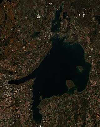
Lake Simcoe is a lake in southern Ontario, Canada, the fourth-largest lake wholly in the province, after Lake Nipigon, Lac Seul, and Lake Nipissing. At the time of the first European contact in the 17th century, the lake was called Ouentironk by the native Wendat/Ouendat (Huron) people. It was also known as Lake Taronto until it was renamed by John Graves Simcoe, the first Lieutenant-Governor of Upper Canada, in memory of his father, Captain John Simcoe of the Royal Navy. In Anishinaabemowin, the historical language of the First Nations living around this lake, namely Anishinaabek of Rama and Georgina Island First Nations, the lake is called Zhooniyaang-zaaga'igan, meaning "Silver Lake".

The Don River is a watercourse in southern Ontario that empties into Lake Ontario, at Toronto Harbour. Its mouth was just east of the street grid of the town of York, Upper Canada, the municipality that evolved into Toronto, Ontario. The Don is one of the major watercourses draining Toronto that have headwaters in the Oak Ridges Moraine.

The Humber River is a river in Southern Ontario, Canada. It is in the Great Lakes Basin, is a tributary of Lake Ontario and is one of two major rivers on either side of the city of Toronto, the other being the Don River to the east. It was designated a Canadian Heritage River on September 24, 1999.

Whitchurch-Stouffville is a town in the Greater Toronto Area of Ontario, Canada, approximately 50 km (31 mi) north of downtown Toronto, and 55 km (34 mi) north-east of Toronto Pearson International Airport. It is 206.22 km2 (79.62 sq mi) in area, and located in the mid-eastern area of the Regional Municipality of York on the ecologically-sensitive Oak Ridges Moraine. Its motto since 1993 is "country close to the city".

The Rouge River is a river in Markham, Pickering, Richmond Hill and Toronto in the Greater Toronto Area of Ontario, Canada. The river flows from the Oak Ridges Moraine to Lake Ontario at the eastern border of Toronto, and is the location of Rouge Park, the only national park in Canada within a municipality. At its southern end, the Rouge River is the boundary between Toronto and southwestern Pickering in the Regional Municipality of Durham.

Bradford is the primary country urban area of the Town of Bradford West Gwillimbury, Ontario, in Canada. It overlooks a farming community, known as The Holland Marsh, located on the Holland River that flows into Lake Simcoe.
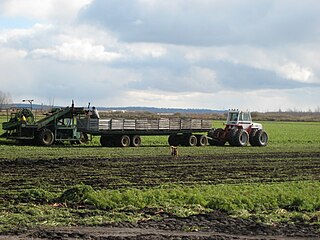
The Holland Marsh is a wetland and agricultural area in Ontario, Canada, about 50 kilometres (31 mi) north of Toronto. It lies entirely within the valley of the Holland River, stretching from the northern edge of the Oak Ridges Moraine near Schomberg to the river mouth at Cook's Bay, Lake Simcoe. In its entirety it comprises about 21,000 acres, with two distinct divisions. Historically it has simply been referred to as "the marsh".

Musselman's Lake is a community settled adjacent to a 118-acre (0.48 km2) kettle lake of the same name in the town of Whitchurch–Stouffville, Ontario, Canada. It is located about 6 km north-northwest of urban Stouffville, and is part of the Greater Toronto Area.
The Toronto and Region Conservation Authority (TRCA) is a conservation authority in southern Ontario, Canada. It owns about 16,000 hectares of land in the Toronto region, and it employs more than 400 full-time employees and coordinates more than 3,000 volunteers each year. TRCA's area of jurisdiction is watershed-based and includes 3,467 square kilometres (1,339 sq mi) – 2,506 on land and 961 water-based in Lake Ontario. This area comprises nine watersheds from west to east – Etobicoke Creek, Mimico Creek, Humber River, Don River, Highland Creek, Petticoat Creek, Rouge River, Duffins Creek and Carruthers Creek.
A conservation authority is a local, community-based natural resource management agency based in Ontario, Canada. Conservation authorities represent groupings of municipalities on a watershed basis and work in partnership with other agencies to carry out natural resource management activities within their respective watersheds, on behalf of their member municipalities and the Province of Ontario.
The East Holland River is a river in Ontario, Canada that is part of the Holland River watershed that empties into Cook's Bay in Lake Simcoe. The headwaters of the East Holland River rise in the Oak Ridges Moraine. The river runs generally north from the town of Newmarket, and through Holland Landing where it joins up with the West Holland River.

The Holland River is a river in Ontario, Canada, that drains the Holland River watershed into Cook's Bay, the southern extremity of Lake Simcoe. The river flows generally north, and its headwaters lie in the Oak Ridges Moraine. The Holland River watershed is approximately 600 square kilometres (230 sq mi), spanning an area that includes New Tecumseth, King Township, Newmarket, Aurora, East Gwillimbury, and Whitchurch-Stouffville. The river's watershed also contains the Holland Marsh, a fertile farmland region renowned for its vegetable production.
Rouge National Urban Park is a national urban park in Ontario, Canada. The park is centred around the Rouge River and its tributaries in the Greater Toronto Area. The southern portion of the park is situated around the mouth of the river in Toronto, and extends northwards into Markham, Pickering, Uxbridge, and Whitchurch-Stouffville.
The Bradford Bypass, also known as the Highway 400–404 Link is a proposed east–west 400-series highway in the northern Greater Toronto Area of the Canadian province of Ontario. The approximately 16.2-kilometre (10.1 mi) route is currently undergoing planning and analysis under an environmental impact assessment (EA) by the Ministry of Transportation of Ontario (MTO) and the Government of Ontario. If approved, a new four-lane controlled-access highway would be built between Highway 400 near Bradford in Simcoe County, and Highway 404 near Queensville in York Region. It would serve as a bypass to the north side of Bradford.

Conservation Ontario is the network of Ontario’s 36 conservation authorities in Ontario, Canada. Conservation Authorities are local, watershed management agencies that deliver services and programs that protect and manage water and other natural resources in partnership with government, landowners and other organizations.

Lake Wilcox is a kettle lake in the Oak Ridges neighbourhood of Richmond Hill, Ontario, Canada. The lake measures 1.5 kilometers across and covers 55.6 hectares or 0.55 square kilometres, making it the largest kettle lake on the Oak Ridges Moraine. Lake Wilcox, Lake St. George and their associated wetlands form a "provincially significant wetland".

The Black River is a river in the Regional Municipality of York and the Regional Municipality of Durham in Central Ontario, Canada. It is part of the Great Lakes Basin, and is a tributary of Lake Simcoe; the entire watershed is under the auspices of the Lake Simcoe Region Conservation Authority.

The Toronto waterway system comprises a series of natural and man-made watercourses in the Canadian city of Toronto. The city is dominated by a large river system spanning most of the city including the Don River, Etobicoke Creek, Highland Creek, Humber River, Mimico Creek and Rouge River.

Lynde Shores Conservation Area is a protected area located in Whitby, Ontario, Canada. Located on the northern shore of Lake Ontario, the conservation area composes the mouth of Lynde Creek and its surrounding marshlands, including Cranberry Marsh. The area is operated by the Central Lake Ontario Conservation Authority.


