
The Bruce Trail is a hiking trail in southern Ontario, Canada, from the Niagara River to the tip of Tobermory, Ontario. The main trail is more than 890 km (550 mi) long and there are over 400 km (250 mi) of associated side trails. The trail mostly follows the edge of the Niagara Escarpment, one of the nineteen UNESCO World Biosphere Reserves in Canada. The land the trail traverses is owned by the Government of Ontario, local municipalities, local conservation authorities, private landowners, and the Bruce Trail Conservancy (BTC). The Bruce Trail is the oldest and longest marked hiking trail in Canada. Its name is linked to the Bruce Peninsula and Bruce County, through which the trail runs. The trail is named after the county, which was named after James Bruce, 8th Earl of Elgin who was Governor General of the Province of Canada from 1847 to 1854.

Halton Hills is a town in the Regional Municipality of Halton, located in the northwestern end of the Greater Toronto Area, Ontario, Canada with a population of 61,161 (2016).

The Kortright Centre for Conservation is a suburban conservation area and educational facility in Vaughan, Ontario, Canada in the northern part of the Greater Toronto Area. It is operated by the Toronto and Region Conservation Authority. The area in which it is located is predominantly forested in its western and northern extent. The Humber River is situated in the west and the Cold Creek and Harris Creek are to the north.

Glanbrook is the south-western district of the city of Hamilton, Ontario, Canada. It was first created as an independent township in 1974 through the amalgamation of Mount Hope, Binbrook, Glanford, and other nearby communities. In 2001, Glanbrook became a dissolved municipality after it was amalgamated with Hamilton, Stoney Creek, Dundas, Ancaster and Flamborough to become the present city of Hamilton.
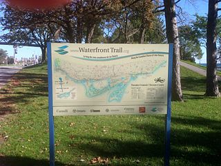
Stretching over 3600 km from Prince Township, west of Sault Ste. Marie, to the Quebec border, the Great Lakes Waterfront Trail is a signed route of interconnecting roads and off-road trails joining over 150 communities and First Nations along the Canadian shores of the Great Lakes and St. Lawrence River. A celebration of nature and culture, the Great Lakes Waterfront Trail is part of a strategy to protect and connect people to the largest group of freshwater lakes on earth. It is a legacy project of the Waterfront Regeneration Trust, a charity, and its community partners. Through Toronto, the trail is called the Martin Goodman Trail. The Waterfront Trail is also used by commuters in parts of Southern Ontario.
Ball's Falls also known as Balls Mills, Louthe Mills and Glen Elgin, is a historical ghost town located in what is now a part of Jordan in the Niagara region, Ontario, Canada, which dates back to the early 19th century. It is now preserved as a conservation area operated by the Niagara Peninsula Conservation Authority.

The Oak Ridges Trail Association (ORTA) is an incorporated charitable organisation whose purpose is to develop, maintain, promote and expand the hiking trail system across the Oak Ridges Moraine in south-central Ontario, Canada. ORTA has ten chapters, each of which maintains a section of the approximately 250 km of trail. The Oak Ridges Trail is connected to the Bruce Trail, Ganaraska Trail, Nokiidaa Trail and Trans Canada Trail. ORTA is governed by a Board of Directors who have responsibilities for managing the various aspects of the organization. Directors on the Board are elected at an Annual General Meeting. ORTA Mission Statement is "To build and maintain a public hiking trail system on the Oak Ridges moraine, off-road where possible, and To organize and promote hiking on this trail system, and To encourage responsible stewardship of the Moraine's natural environment."

Binbrook is a community in southeastern Hamilton, Ontario, in Canada. It was amalgamated into the city of Hamilton in 2001. Since 2001, hundreds of new homes have been built in Binbrook, separated from Hamilton by conservation and agricultural lands.

Rattlesnake Point is an eco-tourism area located in Milton, Ontario, Canada and is owned and operated by Conservation Halton. Spanning roughly one-hundred square kilometres across and near the Niagara Escarpment in Halton Region, the Rattlesnake Point area is home to many golf courses, country markets and equestrian training and boarding facilities. It is a popular scouting area.

Huletts Landing is a hamlet in the town of Dresden in northern Washington County, New York, United States. A lakeside community on the eastern shore of Lake George in the Adirondack Mountains, Huletts Landing is located entirely within the Adirondack Park. There is only one roadway access to the hamlet, County Route 6 and its suffixed routes, which head north–south. Huletts Landing is geographically located at 43°38′21″N73°30′25″W and has approximately two centuries of written history.
Queen Street is a Lower City arterial road in Hamilton, Ontario, Canada. It starts off at Beckett Drive, a mountain-access road in the city and is a two-way street up to Herkimer Street and a one-way street (Southbound) the rest of the way north up to the Canadian National Railway Yard where the road turns right, merging with Stuart Street which travels in a west–east direction.
Kenilworth Avenue is a Lower City arterial road in Hamilton, Ontario, Canada. It starts off at the Kenilworth Traffic Circle and Kenilworth Access, a mountain-access road at the base of the Niagara Escarpment (mountain) and is a two-way street throughout stretching northward through the city's North End industrial neighbourhood where it then flows underneath the Burlington Street bridge and right into Dofasco's Industrial Park.

The Wild Oak Trail is a 27.0-mile (43.5 km) National Recreation Trail located in the Ridge-and-Valley Appalachians in Central Virginia, United States. It is part of George Washington National Forest. The trail is a loop, and begins at the headwaters of the North River, and traverses up to several ridge tops. Due to the trail's difficulty and length, it sees little traffic.
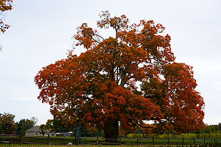
The Comfort Maple tree is an individual sugar maple located in Comfort Maple Conservation Area in the Town of Pelham, Ontario. The tree is estimated to be about 500 years old. If correct, it would make this one of the oldest sugar maple trees in Canada.
The Chessie Nature Trail is a rail trail linking Buena Vista, Virginia with Lexington, Virginia along the Maury River. The six-mile (9.7 km) trail follows the roadbed of a former Chesapeake and Ohio Railway (C&O) branch line which extended from Glasgow, Virginia, to Lexington, primarily following the Maury River.

Schooner Gulch State Beach is a public beach located in Mendocino County, California. It is located approximately 50 miles northwest of Santa Rosa. The park is famous for Bowling Ball Beach, where visitors can view natural spherical sandstone concretions at low tide. The beach offers a scenic spot along the Mendocino coast and a stunning place for watching sunsets. Visitors to the beach come to surf, fish, and picnic. Hiking is also a very popular activity at this beach, and there are multiple trails along the coast.

The Cheltenham Badlands are in Caledon, Ontario, on the southeast side of Olde Base Line Road, between Creditview and Chinguacousy Roads. The site occupies an area of approximately 0.4 square kilometers and features exposed and highly eroded Queenston shale. The Cheltenham Badlands are a significant educational site due to the readily visible geologic processes and the red colour and the unique topography of the exposed shale makes this a popular tourist site. The site is a Provincial Earth Sciences Area of Natural and Scientific Interest (ANSI) since it is considered one of the best examples of "badlands topography" in Ontario.
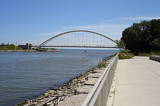
The Martin Goodman Trail is a 56-kilometre (35 mi) multi-use path along the waterfront in Toronto, Ontario, Canada. It traverses the entire lake shore from one end of the city to the other, from Humber Bay Arch Bridge in the west to the Rouge River in the east. The Martin Goodman Trail is part of the 730 km Waterfront Trail around Lake Ontario.
The Niagara Gorge Discovery Center, also known as the Schoellkopf Geological Museum, is on the American side of Niagara Falls within Niagara Falls State Park and the city of Niagara Falls, New York. It opened in 1971. Its role is to showcase the natural history of the Falls and the Niagara Gorge via the ancient rock layers and minerals. The museum also showcases the history of the Great Gorge Route trolley line and features a number of hiking trails.

Bruce's Mill Conservation Area (BMCA) is a conservation area located off Stouffville Road in the town of Whitchurch–Stouffville, Regional Municipality of York, Canada. The conservation area is about 108 hectares in size. BMCA is home to a diverse ecosystem, including 1.2 hectares of wetlands and 44 hectares of deciduous, coniferous and mixed forest. It is owned and managed by the Toronto and Region Conservation Authority (TRCA).

