
Southwick Beach State Park is a New York State park that lies along an unusual stretch of sandy beach on the eastern shore of Lake Ontario. The park is 464 acres (188 ha) in size with a 3,500 foot (1,100 m) length of beach, and is visited annually by about 100,000 people. Immediately to the south is the Lakeview Wildlife Management Area, which extends the publicly accessible beach by several miles. They are in the Town of Ellisburg in Jefferson County, New York south of the lakeside community of Jefferson Park.

Lake Superior Provincial Park is one of the largest provincial parks in Ontario, covering about 1,550 square kilometres (600 sq mi) along the northeastern shores of Lake Superior between Sault Ste. Marie and Wawa in Algoma District in Northeastern Ontario, Canada. Ontario Highway 17 now runs through the park. When the park was established by Ontario in 1944, there was no road access.

Pancake Bay Provincial Park was established in 1968 by Ontario Parks. It is a recreation-class Provincial Park created to help preserve the fragile beach dune ecology. Pancake Bay Provincial Park has one of the highest visitor rates of all the Provincial Parks in the north-east region, and the highest number of campsites. There are 325 campsites, including 160 with electricity. There are three comfort stations. Yurt camping is available in the park. Group camping sites are also available.

Awenda Provincial Park is a provincial park in Tiny Township, Simcoe County in Central Ontario, Canada, located on a peninsula jutting into Georgian Bay north of Penetanguishene. The park occupies an area of 2,915 hectares and was established in 1975. It is classified as a Natural Environment Park and therefore all land is protected.
Ontario Parks is the Ontario government agency in Ontario, Canada, that protects significant natural and cultural resources in a system of parks and protected areas that is sustainable and provides opportunities for inspiration, enjoyment and education. The Ontario Parks system covers over 78,000 square kilometres (30,000 sq mi), which is about 10 percent of the province's surface area or the equivalent of an area approximately equal to Nova Scotia. It falls under the responsibility and mandate of the province's Ministry of the Environment, Conservation and Parks. It was formerly under the mandate of the Ministry of Natural Resources and Forestry.

The North Shore of Lake Superior runs from Duluth, Minnesota, United States, at the western end of the lake, to Thunder Bay and Nipigon, Ontario, Canada, in the north, to Sault Ste. Marie, Ontario in the east. The shore is characterized by alternating rocky cliffs and cobblestone beaches, with forested hills and ridges through which scenic rivers and waterfalls descend as they flow to Lake Superior.

Judge C. R. Magney State Park is a state park in the U.S. state of Minnesota, on the North Shore of Lake Superior. It was named for Clarence R. Magney, a former mayor of Duluth and justice of the Minnesota Supreme Court, who was instrumental in getting 11 state parks and scenic waysides established along the North Shore. The park is best known for the Devil's Kettle, an unusual waterfall and rock formation in which half of the Brule River disappears into a pothole.

Whiteshell Provincial Park is a 2,721 km2 park centrally located in Canada in the province of Manitoba. It is found in the southeast region of the province along the Manitoba-Ontario boundary, approximately 130 km east of the city of Winnipeg. The park is located in the Canadian Shield region and has many rivers, remote lakes, boreal forest and bare granite ridges. It has rare archeological sites of petroforms on flat granite ridges. The park is used year-round for nature-oriented recreation activities.

Big Rideau Lake is a lake in the municipalities of Tay Valley and Drummond/North Elmsley, Lanark County and Rideau Lakes, United Counties of Leeds and Grenville in Eastern Ontario, Canada. The lake is on the border between the two counties, 72 kilometres (45 mi) to the southwest of Ottawa. It is 32 kilometres (20 mi) long and is 6 kilometres (3.7 mi) wide, is much narrower at its northeastern end than at its southwestern end, and is part of the Saint Lawrence River drainage basin. It is the largest lake on the Rideau Canal, which was designated a UNESCO world heritage site in 2007.

Muskallonge Lake State Park is a state park located in Luce County in the U.S. state of Michigan. It is located in Deer Park about 16 miles (25.7 km) west of Grand Marais along H-58.

Rossport is a dispersed rural community and unincorporated place in the Unorganized part of Thunder Bay District in northwestern Ontario, Canada. It is on the north shore of Lake Superior in geographic Lahontan Township, and is on Ontario Highway 17. Rossport is a designated place served by a local services board, and has a population of 65.
Lake Superior National Marine Conservation Area is a National Marine Conservation Area (NMCA) on the north shore of Lake Superior in Ontario, and is a unit of the national park system. Established on September 1, 2015, it is the largest freshwater marine protected area in the world.
Narrow Hills Provincial Park is a northern boreal forest provincial recreational park in the Canadian province of Saskatchewan. It is located in a hilly plateau called the Cub Hills and contains several recreational facilities and over 25 accessible lakes within its boundaries. The geographical features of the park, including the lakes, valleys, and lowlands were formed over 10,000 years ago during the last ice age. The town of Smeaton is the closest community and it is located 70 kilometres (43 mi) to the south.
The Whitesand River is a river in the Unorganized Part of Thunder Bay District in Northwestern Ontario, Canada, part of the Hewitson River system.

Whitesand Lake is a lake in Thunder Bay District, Ontario, Canada, part of the Hewitson River system.

The Hewitson River is a short river in Thunder Bay District, northwestern Ontario, Canada. When the Canadian Pacific Railway was being constructed along the north shore of Lake Superior 1882–1885, the river was known as Maggot River.
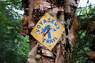
The Voyageur Hiking Trail is a public hiking trail between Sudbury and Thunder Bay in Northern Ontario, Canada. The name honours the early European fur traders of the region who travelled largely by canoe and were known as 'voyageurs’ and ‘coureurs des bois’ The trail is used by all ages and levels of experience, from the day hiker and trail runner to the hardy backpacker.
Porcupine Hills Provincial Park is the newest provincial park in the Canadian Province of Saskatchewan. It was created in 2018 through the amalgamation of five pre-existing provincial recreation sites south-east of the town of Hudson Bay. The park is in the Porcupine Provincial Forest in the Porcupine Hills, which is a geographical feature in eastern Saskatchewan and western Manitoba. The hills are part of a range of hills called the Manitoba Escarpment.
Christina Calayca was a young Filipino-Canadian woman who disappeared from Rainbow Falls Provincial Park, Ontario in 2007. As of 2022, her whereabouts and the circumstances surrounding her disappearance remain unknown.
Piprell Lake is a lake in the Canadian province of Saskatchewan in the boreal forest ecozone of Canada. The lake is located in the Northern Saskatchewan Administration District, just south of the geographical centre of Saskatchewan in the Cub Hills. It is west of the western boundary of Narrow Hills Provincial Park and south-east of Clarence-Steepbank Lakes Provincial Park Piprell Lake Recreation Site and Rainbow Lodge are situated at the northern end of the lake and its amenities are accessed from Highway 913.


