Bronte Creek Provincial Park

Last updated
Bronte Creek Provincial Park
Gfp-canada-ontario-bronte-creek-park-shoreline.jpg
Bronte Creek shoreline
Canada Southern Ontario location map 2.png
Red pog.svg
Location Ontario, Canada
Nearest city Oakville, Ontario
Coordinates 43°24′50″N79°46′0″W / 43.41389°N 79.76667°W / 43.41389; -79.76667
Area6.4 km2 (2.5 sq mi)
Established1975
Governing body Ontario Parks

Bronte Creek Provincial Park is located in Oakville, Ontario, Canada, and is part of the Ontario Parks system.

Contents

The 6.4-square-kilometre (2.5 sq mi) park is located at the western edge of Oakville, bordering on Burlington. The park features hiking and biking trails, cross country skiing, and a play barn. During the summer, swimming is available in a large outdoor swimming pool. [1] Camping in the park is permitted, including sites with electrical hookups. [1]

Bronte Creek Provincial Park has two separate activity areas (day-use and camping) which must be accessed via two separate entrances. Campground must be accessed via 3201 Upper Middle Road W, Oakville. This is off of Bronte Road, exit 111 off the QEW/ 403. The main day-use area is accessed via 1219 Burloak Drive, Oakville. (exit 109 off the QEW/ 403).

History

A provincial park was proposed as early as 1956, with the proposed 32-hectare (79-acre) site being rejected for reasons of size and location. A subsequent proposal for a larger 219-hectare (540-acre) was also rejected; this time due to costs and jurisdiction with the Halton Region Conservation Authority. The current park came into being with help of James W. Snow persuading the Ontario Parks Integration Board in a meeting on Jul 27, 1971. [2]

Education facilities, events and programs

Nature Centre Gfp-canada-ontario-bronte-creek-park-farmhouse.jpg
Nature Centre

Spruce Lane Farmhouse

Built in 1899, this a turn-of-the-century historic house museum near the remaining original apple orchards. [3] Open in the summer, the house features costumed interpreters. Special events and group programs feature historical themes. The park hosts many events including: annual Maple Syrup Festival in March and Harvest Festival in September area both held at the Spruce Lane Farm. Complete list of events can be found on the events page of the Ontario Parks website.

Bronte Creek Provincial Park Farmhouses Bronte farm fall-30.jpg
Bronte Creek Provincial Park Farmhouses

Spring and fall in Bronte Creek is spectacular and a photographer's dream.

Nature Centre

The nature centre offers live animals and exhibits on natural history, and includes aquariums, terrariums, and displays on local reptiles, amphibians, birds, fish and insects. The centre is open from May to September and offers natural history and environmental programs for the general public and visiting groups.

School Group

Education programs are offered both as outreach, in park and via digital links.

Learn to Camp program is offered June - September. Park Ranger guide family groups through a weekend of interactive sessions where participants will learn how to set up a tent, light a campfire and cook a meal outdoors. Reservations are required for this popular program. Almost all equipment is supplied for use during the educational weekend.

Special Events and Programs

Park visitors can enjoy many daily guided programs July and August. These programs are developed with children and families in mind. Topics vary with the season and current concerns such as biodiversity, creatures of the night, life under a log, invasive species and noxious plants. There is a special event offered in just about every month: Family Day activities, Maple Syrup Festival, Victorian Easter, Spring time on the farm, Ghostwalks, Harvest Festival and Victorian Christmas. The park also hosts workshops and fitness sessions: yoga, pilates, photography workshops and plein air painting day.

Campground

Campers must access the campground via Bronte Road and Upper Middle Road in Oakville. A valid camping permit will allow overnight guests to enjoy the programs and facilities in the Day-Use Only Area (Burloak Drive) without paying the vehicle access fee or daily vehicle permit. Campers can enjoy our 1.8 acre or 7000+ square metre outdoor pool in July and August at a reduced daily rate. The Campground is open May - October. Reservations are highly recommended especially if camping in peak season or over a weekend. Sites all have electrical hook ups, a fire pit and picnic table. Water taps are close by and washrooms with showers, laundry and flush toilets are within a short walk of each site. Bronte Creek Provincial Park has 3 yurts, that allow guests who do not have a tent or trailer to experience camping. Want to learn how to camp? Sign up for one of our Learn to Camp sessions where park rangers will guide you through the proper steps set up a tent, dining shelter, cook on a camp stove etc.

Outdoor pool

Open daily in July and August for park guests to enjoy a beach experience of a different sort. Shaped like a bowl the pool gently slopes to a depth of 6 feet. PFD's are available through our PFD lending program. There is an additional fee per person to use the pool for the day. in/out privileges permitted. However, as of the COVID 19 pandemic, the pool is closed until further notice. Visit https://www.ontarioparks.com/park/brontecreek/activities for more information.

Trails

Bronte Creek in fall colours. Bronte creek 6422.jpg
Bronte Creek in fall colours.

Children's farm

The children's farm is located next to the nature centre, and features a mid 19th century barn that has been converted to a play loft and activity area, and stalls with different barnyard animals. Animals on display in the barn and nearby include pigs, chickens, rabbits, goats and sheep. Park staff farm wheat, oats, soybeans and other crops on park land. The children's farm is open year-round.

Disc golf course

The disc golf course is located near parking lot F in the day-use half of the park. The course winds through pine forest and hilly marshland, offering 18 holes of disc golf with both amateur and professional teepads. The course is maintained by the Bronte Creek Disc Golf club which meets on Sundays at 10:00 am for league, which is open to everyone.

Friends of Bronte Creek Park

The Friends of Bronte Creek Park is a non-profit charity run by volunteers at the park whose aim is to enhance the visitor experience at the park. 100% of the funds raised by the Friends is used to support park programs such as summer staff, animal and bird feed and to fund various projects that the Friends undertake.

Related Research Articles

The Queen Elizabeth Way (QEW) is a 400-series highway in the Canadian province of Ontario linking Toronto with the Niagara Peninsula and Buffalo, New York. The freeway begins at the Peace Bridge in Fort Erie and travels 139.1 kilometres (86.4 mi) around the western end of Lake Ontario, ending at Highway 427 in Toronto. The physical highway, however, continues as the Gardiner Expressway into downtown Toronto. The QEW is one of Ontario's busiest highways, with an average of close to 200,000 vehicles per day on some sections. Major highway junctions are at Highway 420 in Niagara Falls, Highway 405 in Niagara-on-the-Lake, Highway 406 in St. Catharines, the Red Hill Valley Parkway in Hamilton, Highway 403 and Highway 407 in Burlington, Highway 403 at the Oakville–Mississauga boundary, and Highway 427 in Etobicoke. Within the Regional Municipality of Halton the QEW is signed concurrently with Highway 403. The speed limit is 100 km/h (62 mph) throughout most of its length, with the exceptions being between Hamilton and St. Catharines where the posted limit is 110 km/h (68 mph).

<span class="mw-page-title-main">Hamlin Beach State Park</span> Park in Hamlin, New York, USA

Hamlin Beach State Park is a 1,287-acre (5.21 km2) state park located on the shore of Lake Ontario in the Town of Hamlin in Monroe County, New York, United States. The Lake Ontario State Parkway passes through the park.

Four Mile Creek State Park is a 248-acre (1.00 km2) state park located in the Town of Porter in Niagara County, New York. The park is at the mouth of Four Mile Creek on the shore of Lake Ontario, approximately 15 miles (24 km) north of the Niagara Falls.

<span class="mw-page-title-main">Lake Superior Provincial Park</span> Provincial park in Ontario, Canada

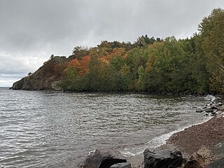
Lake Superior Provincial Park is one of the largest provincial parks in Ontario, covering about 1,550 square kilometres (600 sq mi) along the northeastern shores of Lake Superior between Sault Ste. Marie and Wawa in Algoma District in Northeastern Ontario, Canada. Ontario Highway 17 now runs through the park. When the park was established by Ontario in 1944, there was no road access.

<span class="mw-page-title-main">Pancake Bay Provincial Park</span> Provincial park in Ontario, Canada

Pancake Bay Provincial Park was established in 1968 by Ontario Parks. It is a recreation-class provincial park created to help preserve the fragile beach dune ecology. There are 325 campsites, including 160 with electricity. There are three comfort stations. Yurt camping is available in the park. Group camping sites are also available.

<span class="mw-page-title-main">Kakabeka Falls</span> Waterfall in Ontario, Canada

Kakabeka Falls is a waterfall on the Kaministiquia River, located beside the village of Kakabeka Falls in the municipality of Oliver Paipoonge, Ontario, 30 km (19 mi) west of the city of Thunder Bay.

<span class="mw-page-title-main">Bon Echo Provincial Park</span> Provincial park in Ontario, Canada

Bon Echo Provincial Park is a provincial park in southeastern Ontario, Canada, approximately 6 kilometres (3.7 mi) north of Cloyne. The park is within township boundaries of both North Frontenac and Addington Highlands, roughly separated by Highway 41.

<span class="mw-page-title-main">Bronte, Ontario</span> Unincorporated community in Ontario, Canada

Bronte is the community that makes up much of the west end of Oakville, in Ontario, Canada. Twelve Mile Creek flows through the middle of town and empties into Lake Ontario. Main roads include Bronte Road (north-south), Lakeshore Road West and Rebecca Street (east-west). Streets in the business section include Lakeshore, Jones, Marine, and Ontario Street. Bronte is also accessed via a superhighway located to the north of the former village. Other main roads include Third Line, Speers Road and Burloak Drive to the west

<span class="mw-page-title-main">Sixteen Mile Creek (Halton Region)</span> River in Ontario, Canada

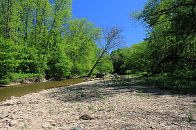
Sixteen Mile Creek is a river in Halton Region in the Greater Toronto Area of Ontario, Canada. It is in the Great Lakes Basin, and flows from the Niagara Escarpment through the towns of Milton and Oakville to Lake Ontario.

<span class="mw-page-title-main">Disney's Fort Wilderness Resort & Campground</span> Resort at Walt Disney World

Disney's Fort Wilderness Resort & Campground is a themed camping resort located in the Magic Kingdom Resort Area at the Walt Disney World Resort in the U.S. state of Florida. It officially opened on November 19, 1971. The resort is situated adjacent to Bay Lake, near Disney's Wilderness Lodge. It also formerly contained Disney's River Country, a water park which closed on November 2, 2001.

Yard Creek Provincial Park is a provincial park located 15 kilometres east of Sicamous along the Trans-Canada Highway in British Columbia, Canada.

<span class="mw-page-title-main">Golden Ears Provincial Park</span> Provincial park in British Columbia, Canada

Golden Ears Provincial Park is a 555.9 square kilometres (214.6 sq mi) provincial park in British Columbia, Canada. It is named after the prominent twin peaks, which are commonly referred to as Golden Ears. The park was originally part of Garibaldi Provincial Park but was split off as a separate park in 1967. The area was logged extensively in the 1920s by the Lougheed and Abernathy Logging Company. Many recreational attractions are found within the park. Golden Ears Provincial Park is a protected area that contains many endangered species of flora and fauna.

Kikomun Creek Provincial Park is a provincial park in British Columbia, Canada.

<span class="mw-page-title-main">French Creek State Park</span> State park in Pennsylvania, United States

French Creek State Park is a 7,977-acre (3,228 ha) Pennsylvania state park in North Coventry and Warwick Townships in Chester County and Robeson and Union Townships in Berks County, Pennsylvania. It straddles northern Chester County and southern Berks County along French Creek. It is located in the Hopewell Big Woods. The park is the home of two lakes: Hopewell Lake, a 68-acre (28 ha) warm water lake, and Scotts Run Lake, a 22-acre (8.9 ha) cold water lake. The state record smallmouth bass was caught in Scotts Run Lake. There are extensive forests, and almost 40 miles (64 km) of hiking and equestrian trails. The park is also friendly to mountain bikers, having some renowned technical trails. Hopewell Furnace National Historic Site, which features a cold blast furnace restored to its 1830s appearance, is surrounded by the park. The Six Penny Day Use Area and Group Camp are listed on the National Register of Historic Places. French Creek State Park is located off of Pennsylvania Route 345 to the south of Birdsboro.

<span class="mw-page-title-main">Moccasin Creek State Park</span>

Moccasin Creek State Park is a 32-acre (13 ha) state park located on the western shore of Lake Burton in Rabun County in the northeast corner of Georgia. The park features campgrounds; a fishing pier for the physically disabled, the elderly, and children; and walking trails. Even though the surrounding area is mountainous, the camping area is relatively flat.

<span class="mw-page-title-main">Lackawanna State Park</span> State park in Pennsylvania, United States

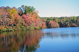
Lackawanna State Park is a 1,445-acre (585 ha) Pennsylvania state park in Benton and North Abington Townships, Lackawanna County, Pennsylvania in the United States. Lake Lackawanna, a 198-acre (80 ha) man-made lake, is the central focus of recreation at the park. Lackawanna State Park is located near Dalton on Pennsylvania Route 524 just off exit 199 of Interstate 81.

<span class="mw-page-title-main">Spring Lake Regional Park</span>

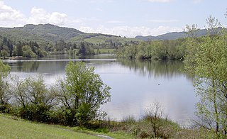
Spring Lake Regional Park is a 320-acre (130 ha) public park in southeastern Santa Rosa, Sonoma County, California, United States. Centered on the Santa Rosa Creek Reservoir, the park is administered by the Sonoma County Regional Parks Department. Its coordinates are 38.45°N 122.65°W, and its official address is 391 Violetti Drive.

<span class="mw-page-title-main">Pinery Provincial Park</span> Provincial park in Ontario, Canada

Pinery Provincial Park is a provincial park located on Lake Huron near Grand Bend, Ontario. It occupies an area of 25.32 square kilometres. It is a natural environment-class Provincial Park created to help preserve oak savannah and the beach dune ecology. It has 1,275 sites of which 404 have electrical hookups. These include the yurt camping area and the group camping sites.

<span class="mw-page-title-main">Cimarron Canyon State Park</span> Wilderness recreation area in New Mexico, US

Cimarron Canyon State Park is a state park of New Mexico, United States, located 3 miles (4.8 km) east of Eagle Nest in the Colin Neblett Wildlife Area. The park extends for 8 miles (13 km) along the Cimarron Canyon between Tolby Creek and Ute Park. The Palisades Sill forms spectacular cliffs above the Cimarron River here.

Albion Hills Conservation Area (AHCA) is located in the Town of Caledon within the Regional Municipality of Peel. AHCA is located eight kilometers north of Bolton, off of Highway 50 at 16500 Highway 50, Palgrave, Ontario. It is owned and managed by the Toronto and Region Conservation Authority (TRCA). AHCA sees about 120,000 visitors each year, who visit the conservation area for mountain biking, camping, swimming, special events, cross-country skiing and more.

References

  1. 1 2 "Bronte Creek Provincial Park". Toronto Life. Archived from the original on 2008-12-02. Retrieved 14 January 2010.
  2. Killan, Gerald (1993). Protected places: a history of Ontario's provincial parks system. Dundurn Press. pp. 212–213. ISBN   978-1-55002-180-6 . Retrieved 2010-01-14.
  3. Killan, Gerald (1993). Protected places: a history of Ontario's provincial parks system. Dundurn Press. p. 220. ISBN   978-1-55002-180-6 . Retrieved 2010-01-14.