
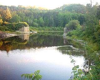
The York River is a river in Renfrew County, Hastings County and Haliburton County in Ontario, Canada. The river is in the Saint Lawrence River drainage basin, and flows from the southern extension of Algonquin Provincial Park to the Madawaska River.

The Municipality of Trent Hills is a township municipality in Northumberland County in Central Ontario, Canada. It is on the Trent River and was created in 2001 through the amalgamation of the municipalities of Campbellford/Seymour, Percy Township and Hastings. Thereafter it was known in brief as Campbellford/Seymour, Percy, Hastings.

Awenda Provincial Park is a provincial park in Tiny Township, Simcoe County in Central Ontario, Canada, located on a peninsula jutting into Georgian Bay north of Penetanguishene. The park occupies an area of 2,915 hectares and was established in 1975. It is classified as a Natural Environment Park and therefore all land is protected.

Restoule Provincial Park is a provincial park in Parry Sound District in Central Ontario, Canada. It is located between Restoule Lake and Stormy Lake and extends along the banks of the Restoule River to its mouth at the French River in geographic Patterson Township and geographic Hardy Township. The park is located at the western terminus of Highway 534 northwest of Restoule, Ontario. The park offers three hiking trails and is home to coyotes, wolves, bears, otters, pine martens, moose and one of Ontario's largest white-tailed deer herds. It is also home to over 90 species of birds including the peregrine falcon and the heron. Camping areas include Bells Point, Putts Point and Kettle Point. Many hike the well-marked trail to the 100-foot (30 m) fire tower overlooking Stormy Lake. It is one of two provincial parks found in the Almaguin Highlands.

South Algonquin is a township municipality in Nipissing District, Ontario, Canada. Located south of Algonquin Provincial Park, it is the sole populated portion of the district that lies south of the traditional dividing line between Northern Ontario and Southern Ontario and is closer connected to Renfrew County as opposed to the core portions of Nipissing District.

James is an incorporated township in the Canadian province of Ontario, located in Timiskaming District. The primary community within the township is Elk Lake, which is located at the junction of Ontario Highway 65 and Ontario Highway 560.
St. Ola is a dispersed rural community in the township municipality of Limerick, Hastings County in Central Ontario, Canada. It takes its name from the parish of St. Olaf in Kirkwall, Orkney Islands, and is now largely unoccupied.
Kap-Kig-Iwan Provincial Park is a protected area in the incorporated townships of Charlton and Dack and Evanturel in Timiskaming District in Northeastern Ontario, Canada. Established in 1957, the 325-hectare (803-acre) park is located along the Englehart River, off Ontario Highway 11 about 2 kilometres (1.2 mi) south of the town of Englehart. Kap-Kig-Iwan is classified as a Natural Environment park and is a provincial park of Ontario.
The Little White River is a river in the Unorganized North Part of Algoma District in Northeastern Ontario, Canada. It is in the Great Lakes Basin and is a left tributary of the Mississagi River.
The Matawin River is a river in Thunder Bay District in Northwestern Ontario, Canada. It is in the Great Lakes Basin and is a right tributary of the Kaministiquia River.
The Makobe River is a river in northeastern Ontario, Canada. It is in the Saint Lawrence River drainage basin, and is a left tributary of the Montreal River.
Sucker Creek is a stream in geographic Osborne Township in the Unorganized North Part of Nipissing District in Northeastern Ontario, Canada. It is in the Saint Lawrence River drainage basin and is a tributary of Little Sucker Lake. Sucker Creek forms part of the border of Jocko Rivers Provincial Park.
Carroll Lake is an irregularly-shaped lake in the province of Manitoba, and in the Unorganized Part of Kenora District in Northwestern province of Ontario, Canada. It is in the Hudson Bay drainage basin, and, with the exception of portions of two small bays in the west, lies mostly in Ontario. The Ontario portion of the lake is within Woodland Caribou Provincial Park, and the small Manitoba portions within Atikaki Provincial Wilderness Park.
René Brunelle Provincial Park is a provincial park in both the municipality of Moonbeam and geographic Gurney Township in Unorganized North Cochrane District, Cochrane District, in Northeastern Ontario, Canada. Established in 1957 and named in 1981 for René Brunelle, it is operated by Ontario Parks and has camping, hiking, swimming and other facilities on or near Remi Lake.

The Centennial Lake Provincial Nature Reserve is a provincial park located in the municipality of Greater Madawaska, Renfrew County, in Eastern Ontario, Canada. The 530-hectare (1,300-acre) reserve was created in 1989 and is managed by Ontario Parks.
McKenzie Lake is a lake in South Algonquin, Nipissing District and Hastings Highlands, Hastings County in Ontario, Canada. It is in the Saint Lawrence River drainage basin, is part of the Madawaska River river system, and lies about 14 kilometres (9 mi) south of the community of Madawaska and a similar distance north of the small town of Maynooth. The settlement of McKenzie Lake is on the north shore of the lake.
McKenzie Lake is a lake in the Unorganized Part of Rainy River District in northwestern Ontario, Canada. It is part of the Hudson Bay drainage basin, and lies within Quetico Provincial Park.

Silver Lake is a lake in Tay Valley, Lanark County, and Central Frontenac, Frontenac County, in Eastern Ontario, Canada. It is the source of Silver Lake Creek and is in the Ottawa River drainage basin.
Weepine Lake is a small lake in the municipality of Dysart et al, Haliburton County in Central Ontario, Canada. It is within Algonquin Provincial Park and is part of the Ottawa River drainage basin.
Fourcorner Lake is a lake in the municipality of Dysart et al, Haliburton County in Central Ontario, Canada. It is partly within Algonquin Provincial Park and is in the Ottawa River drainage basin. The lake takes its name from its location at a quadripoint, the junction point of four geographic townships: Harburn at northwest, Bruton at the northeast, Harcourt at the southeast, and Dudley at the southwest.


