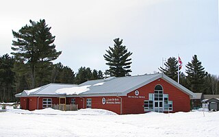
Lake of Bays is a township municipality within the District Municipality of Muskoka, Ontario, Canada. The township, situated 193 kilometres (120 mi) north of Toronto, is named after the Lake of Bays. During the 2016 census, the township had a population of 3,167 and encompassed 677.91 square kilometres (261.74 sq mi) of land.

The Madawaska River is a river in the Saint Lawrence River drainage basin in Ontario, Canada. The river is 230 km (143 mi) long and drains an area of 8,470 km2 (3,270 sq mi). Its name comes from an Algonquian band of the region known as "Matouweskarini", meaning "people of the shallows".

The English River is a river in Kenora District and Thunder Bay District in Northwestern Ontario, Canada. It flows through Lac Seul to join the Winnipeg River at Tetu Lake as a right tributary. The river is in the Hudson Bay drainage basin, is 615 kilometres (382 mi) long and has a drainage basin of 52,300 square kilometres (20,200 sq mi). Although there are several hydroelectric plants on this river, the English River upstream of Minnitaki Lake is notable as one of the few large river systems in northwestern Ontario with a natural flow and without any upstream source of pollution. It is the fourth longest river entirely in Ontario.

The Barron River is a river in the Saint Lawrence River drainage basin in Nipissing District and Renfrew County, Ontario, Canada. It flows from Clemow Lake in northern Algonquin Provincial Park and joins the Petawawa River, whose southern branch it forms, in the municipality of Laurentian Hills, near the municipality of Petawawa.

Lake Nipigon is part of the Great Lakes drainage basin. It is the largest lake entirely within the boundaries of the Canadian province of Ontario.
Balsam Lake is a lake in the City of Kawartha Lakes in Central Ontario, Canada. It is in the Great Lakes Basin, is one of the lakes of the Kawartha Lakes, and is at the summit of the Trent–Severn Waterway.

Awenda Provincial Park is a provincial park in Tiny Township, Simcoe County in Central Ontario, Canada, located on a peninsula jutting into Georgian Bay north of Penetanguishene. The park occupies an area of 2,915 hectares and was established in 1975. It is classified as a Natural Environment Park and therefore all land is protected.

Latchford is a single-tier municipality town in Timiskaming District in Northeastern Ontario, Canada. It is located on Bay Lake on the Montreal River, near the town of Cobalt and the municipality of Temagami, and is 20 kilometres from the city of Temiskaming Shores. The population of the town in the Canada 2011 Census was 387, which makes it the smallest town by population in Ontario. The town's slogan is "The Best Little Town by a Dam Site!"

Rossport is a dispersed rural community and unincorporated place in the Unorganized part of Thunder Bay District in northwestern Ontario, Canada. It is on the north shore of Lake Superior in geographic Lahontan Township, and is on Ontario Highway 17. Rossport is a designated place served by a local services board, and has a population of 65.
Upper Madawaska River Provincial Park is a waterway-class provincial park on the Madawaska River in the municipality of South Algonquin in Nipissing District, Ontario, Canada. The park consists of a strip of land along both shores of the Madawaska River from the communities of Whitney to Madawaska. It is upstream and north of the Lower Madawaska River Provincial Park.

Jack Lake is a lake and reservoir in the municipalities of Havelock-Belmont-Methuen and North Kawartha, Peterborough County in Central Ontario, Canada, about 100 mi (160 km) directly northeast of Toronto and at the edge of the Canadian Shield in the northeastern portion of the Kawartha lakes region. The lake is in the Great Lakes Basin, and serves as a small headwater pond for the Trent-Severn Waterway. The Dispersed rural community of Jack Lake is on the northwest shore of the lake, reached by Peterborough County Road 52 / Jack Lake Road from the community of Apsley, about 5 kilometres (3.1 mi) to the north on Ontario Highway 28.
Beausoleil Island; Île Beausoleil; is an 8-kilometre (5.0 mi) long island in the municipality of Georgian Bay, District Municipality of Muskoka in Central Ontario, Canada. The island is named after Louis Beausoleil, a Métis settler whose 1819 homestead stood at the island's southern tip. The name of the island in the Huron-Wendat language is Skiondechiara which means "The land to appear floating afar". The name of the island in the Anishinaabemowin language is variously Pamedenagog, Baamidoonegog or Epenmindaagoog meaning “rocky place floating about the mouth of a river”. Located in the Thirty Thousand Islands in Georgian Bay on Lake Huron, it is the largest island in Georgian Bay Islands National Park and is the only place in the park where camping is allowed. Beausoleil Island is also part of the Georgian Bay Littoral UNESCO Biosphere reserve.

Batchawana Bay is an unincorporated place and Compact Rural Community in Algoma District in Northeastern Ontario, Canada. It is also the name of a local services board, consisting of parts of the geographic townships of Fisher, Herrick, Ryan and Tilley. It is located north of Sault Ste. Marie, Ontario, on the shores of Batchawana Bay off Lake Superior.
Porphyry Island is an island in Unorganized Thunder Bay District in northwestern Ontario, Canada. It is the last island in a chain stretching south west of the Black Bay Peninsula in Lake Superior. It is located about 6 kilometres (4 mi) from Edward Island Provincial Park, 13 kilometres (8 mi) from Sleeping Giant Provincial Park, 14 kilometres (9 mi) east of Silver Islet, Ontario, and 42 kilometres (26 mi) east of the city of Thunder Bay.
Black Bay Peninsula is a volcanic peninsula in Unorganized Thunder Bay District in Northwestern Ontario, Canada, located on the North Shore of Lake Superior. It separates Black Bay and Nipigon Bay and consists of over 300 flood basalt lava flows. Porphyry Island, an island entirely encompassed within Porphyry Island Provincial Park, lies off the tip of the peninsula. A 49-square-kilometre (19 sq mi) portion of the peninsula has been set aside as the Black Bay Peninsula Enhanced Management Area.
The Kashabowie River is a river in southwestern Thunder Bay District in Northwestern Ontario, Canada. It is in the Great Lakes Basin and is a tributary of the Shebandowan Lakes.
Remi Lake is a lake in both the municipality of Moonbeam and geographic Gurney Township in Unorganized North Cochrane District, Cochrane District, in Northeastern Ontario, Canada. It is in the James Bay drainage basin.
René Brunelle Provincial Park is a provincial park in both the municipality of Moonbeam and geographic Gurney Township in Unorganized North Cochrane District, Cochrane District, in Northeastern Ontario, Canada. Established in 1957 and named in 1981 for René Brunelle, it is operated by Ontario Parks and has camping, hiking, swimming and other facilities on or near Remi Lake.
The Remi River is a river in the Unorganized North Part of Cochrane District in Northeastern Ontario, Canada. It is in the James Bay drainage basin and is a right tributary of the Kapuskasing River.

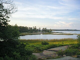
The Centennial Lake Provincial Nature Reserve is a provincial park located in the municipality of Greater Madawaska, Renfrew County, in Eastern Ontario, Canada. The 530-hectare (1,300-acre) reserve was created in 1989 and is managed by Ontario Parks.

