
The Aire and Calder Navigation is the canalised section of the Rivers Aire and Calder in West Yorkshire, England. The first improvements to the rivers above Knottingley were completed in 1704 when the Aire was made navigable to Leeds and the Calder to Wakefield, by the construction of 16 locks. Lock sizes were increased several times, as was the depth of water, to enable larger boats to use the system. The Aire below Haddlesey was bypassed by the opening of the Selby Canal in 1778. A canal from Knottingley to the new docks and new town at Goole provided a much shorter route to the River Ouse from 1826. The New Junction Canal was constructed in 1905, to link the system to the River Don Navigation, by then part of the Sheffield and South Yorkshire Navigation.

A lock is a device used for raising and lowering boats, ships and other watercraft between stretches of water of different levels on river and canal waterways. The distinguishing feature of a lock is a fixed chamber in which the water level can be varied; whereas in a caisson lock, a boat lift, or on a canal inclined plane, it is the chamber itself that rises and falls.

The Trent–Severn Waterway is a 386-kilometre-long (240 mi) canal route connecting Lake Ontario at Trenton to Georgian Bay, Lake Huron, at Port Severn. Its major natural waterways include the Trent River, Otonabee River, Kawartha Lakes, Lake Simcoe, Lake Couchiching and Severn River. Its scenic, meandering route has been called "one of the finest interconnected systems of navigation in the world".

The Falkirk Wheel is a rotating boat lift in Tamfourhill, Falkirk, in central Scotland, connecting the Forth and Clyde Canal with the Union Canal. It reconnects the two canals for the first time since the 1930s. It opened in 2002 as part of the Millennium Link project.
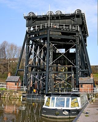
The Anderton Boat Lift is a two-caisson lift lock near the village of Anderton, Cheshire, in North West England. It provides a 50-foot (15.2 m) vertical link between two navigable waterways: the River Weaver and the Trent and Mersey Canal. The structure is designated as a scheduled monument, and is included in the National Heritage List for England; it is also known as one of the Seven Wonders of the Waterways.
The Otonabee River is a river in Peterborough County in Central Ontario, Canada. The river flows from Katchewanooka Lake, at the north end of the community of Lakefield, through the city of Peterborough to Rice Lake. It is in the Great Lakes Basin and forms part of the Trent-Severn Waterway.
The Grand Western Canal ran between Taunton in Somerset and Tiverton in Devon in the United Kingdom. The canal had its origins in various plans, going back to 1796, to link the Bristol Channel and the English Channel by a canal, bypassing Lands End. An additional purpose of the canal was the supply of limestone and coal to lime kilns along with the removal of the resulting quicklime, which was used as a fertiliser and for building houses. This intended canal-link was never completed as planned, as the coming of the railways removed the need for its existence.

A boat lift, ship lift, or lift lock is a machine for transporting boats between water at two different elevations, and is an alternative to the canal lock.

The Panama Canal locks are a lock system that lifts ships up 85 feet to the main elevation of the Panama Canal and down again. The original canal had a total of six steps for a ship's passage. The total length of the lock structures, including the approach walls, is over 1.9 miles (3 km). The locks were one of the greatest engineering works ever to be undertaken when they opened in 1914. No other concrete construction of comparable size was undertaken until the Hoover Dam, in the 1930s.

The Strépy-Thieu boat lift lies on a branch of the Canal du Centre in the municipality of Le Rœulx, Hainaut, Belgium. With a height difference of 73.15 metres (240.0 ft) between the upstream and downstream reaches, it was the tallest boat lift in the world upon its completion, and remained so until the Three Gorges Dam ship lift in China was completed in January 2016.

The lifts on the Canal du Centre are a series of four hydraulic boat lifts near the town of La Louvière in Belgium which are classified as a World Heritage Site by UNESCO. All four are located on the Canal du Centre in Belgium's historic sillon industriel industrial belt.

The caisson lock is a type of canal lock in which a narrowboat is floated into a sealed watertight box and raised or lowered between two different canal water levels. It was invented in the late 18th century as a solution to the problem posed by the excessive demand for water when conventional locks were used to raise and lower canal boats through large height differences. Such locks, each of which would only raise and lower boats through small height differences of a few feet, would not suffice when large height differences had to be tackled nor when water was in short supply. The caisson was thought to be one solution, although it transpired that the technology of the day was not capable of achieving this type of construction economically.

Tardebigge Locks or the Tardebigge Flight is the longest flight of locks in the UK, comprising 30 narrow locks on a two-and-a-quarter-mile (3.6 km) stretch of the Worcester and Birmingham Canal at Tardebigge, Worcestershire. It raises the waterway 220 feet (67 m), and lies between the Tardebigge tunnel to the North and the Stoke Prior flight of six narrow locks to the South. The Tardebigge Engine House is also on this stretch.
Kirkfield is a village located in the city of Kawartha Lakes, in the Canadian province of Ontario. The unincorporated village was named in 1864 after the initial name, Novar, was rejected by the government. A list of 8 possible choices was then offered. The village, being predominantly Scottish at the time, chose Kirkfield, after Kirk' o' Field in Edinburgh. It is home to Lock 36 of the Trent-Severn Waterway, a hydraulic lift lock which connects Canal Lake and the artificially flooded Mitchell Lake. Travellers and commuters pass through Kirkfield regularly while travelling on Highway 48 west towards Highway 12 and east towards Highway 35.

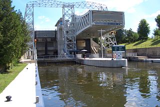
The Kirkfield Lift Lock is a boat lift located in the city of Kawartha Lakes, Ontario, Canada, near the village of Kirkfield. It is designated "Lock 36" of the Trent–Severn Waterway, situated at the highest section of the canal. It is Canada's second lift lock, the other one is the Peterborough Lift Lock, located on the same canal system.
Mitchell Lake is a small, artificial lake in the Great Lakes Basin and located in the city of Kawartha Lakes in Central Ontario, Canada. The lake was formed sometime in the first decade of the twentieth century alongside the construction of the Kirkfield Lift Lock, which was completed and operational by the end of 1907. It is part of the summit of the Trent–Severn Waterway, the middle of a connection via canals of Balsam Lake on the Gull River system, which flows eventually to Lake Ontario, and the Kirkfield Lift Lock and Canal Lake on the Talbot River system, which flows to Lake Simcoe and eventually to Lake Huron.

Burleigh Falls is both a geological feature and a small community in Peterborough County, Ontario, Canada. The falls form the boundary between the municipality of North Kawartha to the north and the municipality of Selwyn to the south.

Canal Lake is a lake of Ontario, Canada, situated in the City of Kawartha Lakes. The lake is triangular, roughly 8.4 kilometres (5.2 mi) long and 2.6 kilometres (1.6 mi) at its widest point, with an area of 2,136 acres (864 ha). The depth ranges from 4.44 feet (1.35 m) to a max depth of 15 feet (4.6 m). Canal Lake is a medium size lake with a large diversity of fishing spots.

Little Lake is a small lake on the Otonabee River in the city of Peterborough, Ontario, Canada. The lake is in the downtown of the city and is used for fishing, swimming, boating, and for various special events. The lake lies on the water route from Lake Ontario to the Kawartha Lakes. The area around the lake was first settled by Europeans around the start of the 19th century. Steam- and water-powered saw mills were built on the lake and on the river upstream to prepare lumber for shipment overseas. Sawdust and other debris from the mills polluted the lake, killed the fish and clogged up the navigable channels. The smell was so noxious it drove residents near the lake to move. These problems were resolved by the end of the century, when the lake became a hub on the new Trent-Severn Waterway from Lake Ontario to Lake Huron. However, industries attracted by cheap hydroelectric power, such as General Electric used the lake for disposal of industrial chemicals for many years. The pollutants seems to be mostly contained in the sediment, and the lake is now considered safe for recreational use.


