De Soto, Illinois

Last updated

De Soto, Illinois
Jackson County Illinois Incorporated and Unincorporated areas De Soto Highlighted.svg
Location of De Soto in Jackson County, Illinois
Illinois in United States (US48).svg
Location of Illinois in the United States
Coordinates: 37°48′56″N89°13′41″W / 37.81556°N 89.22806°W / 37.81556; -89.22806
CountryUnited States
StateIllinois
County Jackson
Township De Soto
Area
[1]
  Total0.92 sq mi (2.39 km2)
  Land0.91 sq mi (2.36 km2)
  Water0.01 sq mi (0.03 km2)
Elevation
[2]
404 ft (123 m)
Population
 (2020)
  Total1,407
  Density1,542.76/sq mi (595.48/km2)
Demonym De Soto Rat
Time zone UTC-6 (CST)
  Summer (DST) UTC-5 (CDT)
ZIP Code(s)
62924
Area code 618
FIPS code 17-19616
GNIS feature ID2398695 [2]
Wikimedia CommonsDe Soto, Illinois
Website villageofdesoto.com

De Soto is a village in Jackson County, Illinois, United States. The population was 1,590 at the 2010 census, [3] down from 1,653 at the 2000 census. It is named for Hernando de Soto, the discoverer of the Mississippi River. [4]

Contents

Geography

De Soto is located in northeastern Jackson County at 37°48′56″N89°13′41″W / 37.815660°N 89.228184°W / 37.815660; -89.228184 . [5] U.S. Route 51 passes through the center of the village, leading north 13 miles (21 km) to Du Quoin and south 6 miles (10 km) to Carbondale. Illinois Route 149 crosses US-51 in the village center, leading southwest 7 miles (11 km) to Murphysboro, the Jackson county seat, and east 5 miles (8 km) to Hurst.

According to the 2010 census, De Soto has a total area of 0.922 square miles (2.39 km2), of which 0.91 square miles (2.36 km2) (or 98.7%) is land and 0.012 square miles (0.03 km2) (or 1.3%) is water. [6] The Big Muddy River, a tributary of the Mississippi River, flows to the east and south of the village limits.

History

Destruction of after the 1925 tornado Illinois - Desoto - NARA - 23939847 (cropped).jpg
Destruction of after the 1925 tornado

De Soto was laid out in 1854 when the railroad was extended to that point. [7] The village's name honors Hernando de Soto (c. 1496/1497–1542), a Spanish conquistador who explored the region in 1541-2. [8] A post office has been in operation at De Soto since 1855. [9]

De Soto was largely destroyed by the Great Tri-State Tornado of 1925. Sixty-nine people died in De Soto when approximately 30% of the town was destroyed, and of this total 33 were children at a local school that collapsed from the winds. The tornado affected Missouri, Illinois, and Indiana, killing 695 and injuring over 2,000.[ citation needed ]

Demographics

Historical population
CensusPop.Note
1890 376
1900 56048.9%
1910 64415.0%
1920 7039.2%
1930 673−4.3%
1940 656−2.5%
1950 646−1.5%
1960 72311.9%
1970 96633.6%
1980 1,58964.5%
1990 1,500−5.6%
2000 1,65310.2%
2010 1,590−3.8%
2020 1,407−11.5%
U.S. Decennial Census [10]

As of the census [11] of 2000, there were 1,653 people, 673 households, and 444 families residing in the village. The population density was 1,752.4 inhabitants per square mile (676.6/km2). There were 726 housing units at an average density of 769.7 per square mile (297.2/km2). The racial makeup of the village was 97.58% White, 0.73% African American, 0.06% Native American, 0.42% Asian, 0.18% from other races, and 1.03% from two or more races. Hispanic or Latino of any race were 1.57% of the population.

There were 673 households, out of which 33.9% had children under the age of 18 living with them, 51.4% were married couples living together, 11.3% had a female householder with no husband present, and 33.9% were non-families. 27.3% of all households were made up of individuals, and 9.7% had someone living alone who was 65 years of age or older. The average household size was 2.45 and the average family size was 3.02.

In the village, the population was spread out, with 26.1% under the age of 18, 10.0% from 18 to 24, 33.3% from 25 to 44, 20.3% from 45 to 64, and 10.2% who were 65 years of age or older. The median age was 33 years. For every 100 females, there were 94.5 males. For every 100 females age 18 and over, there were 90.5 males.

The median income for a household in the village was $31,563, and the median income for a family was $34,929. Males had a median income of $30,400 versus $22,632 for females. The per capita income for the village was $15,526. About 10.1% of families and 14.3% of the population were below the poverty line, including 19.7% of those under age 18 and 11.1% of those age 65 or over.

Related Research Articles

<span class="mw-page-title-main">Childersburg, Alabama</span> City in Alabama, United States

Childersburg is a city in Talladega County in the U.S. state of Alabama. It was incorporated in 1889. At the 2020 census, the population was 4,754. It has a history dating back before 1540, when it was noted as a village of the Coosa Nation visited by the Spanish explorer Hernando de Soto. It is said a member of De Soto’s crew fell ill and was left to settle in the area of present day Childersburg where the Coosa people cared for the ill explorer. The Alabama Army Ammunition Plant, important during World War II, was located 4 miles (6 km) north of Childersburg.

<span class="mw-page-title-main">Lake Village, Arkansas</span> City in Arkansas, United States

Lake Village is a city in and the county seat of Chicot County, Arkansas, United States. The population was 2,575 at the 2010 census. It is located in the Arkansas Delta. Lake Village is named for its location on Lake Chicot, an oxbow lake formed by the Mississippi River.

<span class="mw-page-title-main">East Cape Girardeau, Illinois</span> Village in Illinois, United States

East Cape Girardeau is a village in Alexander County, Illinois, United States. The population was 289 at the 2020 census. It is part of the Cape Girardeau–Jackson, MO-IL Metropolitan Statistical Area.

<span class="mw-page-title-main">Pesotum, Illinois</span> Village in Illinois, United States

Pesotum is a village in Champaign County, Illinois, United States. The population was 551 at the 2010 census.

<span class="mw-page-title-main">Marietta, Illinois</span> Village in Illinois, United States

Marietta is a village in Fulton County, Illinois, United States. The population was 101 at the 2020 census.

<span class="mw-page-title-main">Campbell Hill, Illinois</span> Village in Illinois, United States

Campbell Hill is a village in Jackson County, Illinois, United States. The population was 309 at the 2020 census.

<span class="mw-page-title-main">Elkville, Illinois</span> Village in Illinois, United States

Elkville is a village in Jackson County, Illinois, United States. The population was 928 at the 2010 census, down from 1,001 at the 2000 census. As of 2018 the estimated population was 871.

<span class="mw-page-title-main">Vergennes, Illinois</span> Village in Illinois, United States

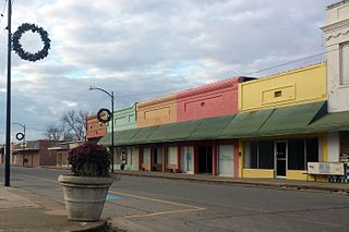
Vergennes is a village in Jackson County, Illinois, United States. The population was 298 at the 2010 census, down from 491 at the 2000 census.

<span class="mw-page-title-main">Willow Hill, Illinois</span> Village in Illinois, United States

Willow Hill is a village in Jasper County, Illinois. The population was 230 at the 2010 census.

<span class="mw-page-title-main">Island Lake, Illinois</span> Village in Illinois, United States

Island Lake is a village in Lake and McHenry counties in the U.S. state of Illinois. Per the 2020 census, the population was 8,051. The village surrounds Island Lake, a lake which contains a small island.

<span class="mw-page-title-main">Spring Grove, Illinois</span> Village in Illinois, United States

Spring Grove is a village in McHenry County. Portions of unincorporated Lake County, Illinois also utilize Spring Grove postal addresses. It is a commuter village within the Chicago metropolitan area. Per the 2020 census, the population was 5,487. It is also home to Chain O'Lakes State Park.

<span class="mw-page-title-main">Armington, Illinois</span> Village in Illinois, United States

Armington is a village in Tazewell County, Illinois, United States. The population was 368 at the 2000 census. It is part of the Peoria, Illinois Metropolitan Statistical Area.

<span class="mw-page-title-main">Belgium, Illinois</span> Village in Illinois, United States

Belgium is a village in Vermilion County, Illinois, United States. It is part of the Danville, Illinois Metropolitan Statistical Area. The population was 404 at the 2010 census.

<span class="mw-page-title-main">Longstreet, Louisiana</span> Village in Louisiana, United States

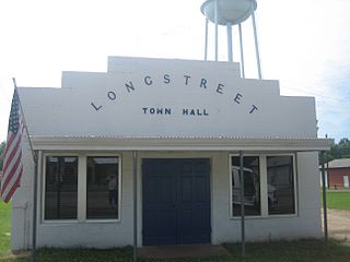
Longstreet is a village in DeSoto Parish, Louisiana, United States. The population was 157 at the 2010 census. It is part of the Shreveport–Bossier City Metropolitan Statistical Area.

<span class="mw-page-title-main">Stanley, Louisiana</span> Village in Louisiana, United States

Stanley is a village in DeSoto Parish, Louisiana, United States. The population was 107 at the 2010 census, down from 145 in 2000. It is part of the Shreveport–Bossier City Metropolitan Statistical Area.

<span class="mw-page-title-main">Grass Lake Charter Township, Michigan</span> Charter township in Michigan, United States

Grass Lake Charter Township is a charter township of Jackson County in the U.S. state of Michigan. The population was 6,069 at the 2020 census, up from 5,684 at the 2010 census.

<span class="mw-page-title-main">Hernando, Mississippi</span> City in Mississippi, United States

Hernando is the county seat of DeSoto County, on the northwestern border of Mississippi, United States. The population was 17,138 according to the 2020 census records. DeSoto County is the second-most-populous county in the Memphis metropolitan area, which includes counties in Tennessee, Arkansas and Mississippi.

<span class="mw-page-title-main">Latimer, Mississippi</span> Census-designated place in Mississippi, United States

Latimer is a census-designated place (CDP) in Jackson County, Mississippi, United States. It is part of the Pascagoula Metropolitan Statistical Area. The population was 6,079 at the 2010 census, up from 4,288 at the 2000 census.

<span class="mw-page-title-main">Horn Lake, Mississippi</span> City in Mississippi, United States

Horn Lake is a city in DeSoto County, Mississippi, United States. It is located 1.2 mi (1.9 km) south of Memphis, Tennessee. The population was 26,736 at the 2020 census, making it the 13th most populous city in Mississippi.

<span class="mw-page-title-main">De Soto, Wisconsin</span> Village in Wisconsin, United States

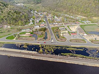
De Soto is a village mostly in Vernon County but also in Crawford County in Wisconsin, United States. The population was 287 at the 2010 census. Of this, 179 were in living in Vernon County, and 108 were living in Crawford County. The downtown and business area is located in Crawford County.

References

  1. "2020 U.S. Gazetteer Files". United States Census Bureau. Retrieved March 15, 2022.
  2. 1 2 U.S. Geological Survey Geographic Names Information System: De Soto, Illinois
  3. "Geographic Identifiers: 2010 Census Summary File 1 (G001): De Soto village, Illinois". American Factfinder. U.S. Census Bureau. Archived from the original on February 13, 2020. Retrieved May 9, 2018.
  4. Gannett, Henry (1905). The Origin of Certain Place Names in the United States. Govt. Print. Off. p. 105.
  5. "US Gazetteer files: 2010, 2000, and 1990". United States Census Bureau. February 12, 2011. Retrieved April 23, 2011.
  6. "G001 - Geographic Identifiers - 2010 Census Summary File 1". United States Census Bureau. Archived from the original on February 13, 2020. Retrieved August 2, 2015.
  7. "History". Village of De Soto, IL. Archived from the original on April 12, 2015. Retrieved November 4, 2015.
  8. Callary, Edward (September 29, 2008). Place Names of Illinois. University of Illinois Press. p. 92. ISBN   978-0-252-09070-7.
  9. "Jackson County". Jim Forte Postal History. Archived from the original on September 11, 2005. Retrieved November 4, 2015.
  10. "Census of Population and Housing". Census.gov. Retrieved June 4, 2015.
  11. "U.S. Census website". United States Census Bureau . Retrieved January 31, 2008.