
The Smith River is a 90-mile (140 km) tributary of the Umpqua River in the U.S. state of Oregon. It drains 352 square miles (910 km2) of the Central Oregon Coast Range between the watershed of the Umpqua to the south and the Siuslaw River to the north.
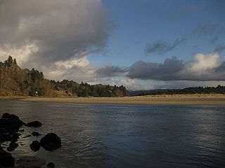
The Salmon River flows from the Central Oregon Coast Range to the Pacific Ocean coast of northwest Oregon in the United States. About 24 miles (39 km) long, it begins and ends in Lincoln County but also flows briefly through western Polk and southern Tillamook counties. Much of its course lies within the Siuslaw National Forest.
The Middle Santiam River is a tributary of the South Santiam River, 38.5 miles (62.0 km) long, in western Oregon in the United States. It drains a remote area of the Cascade Range east of Sweet Home in the watershed of the Willamette River.

The Umatilla River is an 89-mile (143 km) tributary of the Columbia River in northern Umatilla County, Oregon, United States. Draining a basin of 2,450 square miles (6,300 km2), it enters the Columbia near the city of Umatilla in the northeastern part of the state. In downstream order, beginning at the headwaters, major tributaries of the Umatilla River are the North Fork Umatilla River and the South Fork Umatilla River, then Meacham, McKay, Birch, and Butter creeks.
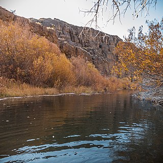
West Little Owyhee River is a 63.1-mile-long (101.5 km) tributary of the Owyhee River in the U.S. state of Oregon. The source of the river is at an elevation of 6,508 feet (1,984 m) near McDermitt, while the mouth is at an elevation of 4,373 feet (1,333 m) in the Owyhee Desert. West Little Owyhee River has a 310-square-mile (800 km2) watershed.
Five Rivers is a tributary of the Alsea River in the U.S. state of Oregon, in Lane, Lincoln, Benton counties. The name Five Rivers refers to the relative importance to the stream of five of its tributaries: Alder, Cougar, Buck, Crab, and Cherry creeks.
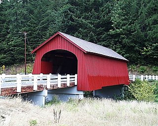
Wildcat Creek is a 16-mile-long (26 km) creek in Lane County, Oregon, United States within the Siuslaw National Forest. The creek empties into the Siuslaw River at Austa on Oregon Route 126.
Tenmile Creek is a stream in Lane County, in the U.S. state of Oregon. It flows west from the Siuslaw National Forest in the Oregon Coast Range into the Pacific Ocean at Stonefield Beach State Recreation Site, about 6 miles (10 km) south of Yachats.

The North Fork Alsea River is a 16-mile (26 km) tributary of the Alsea River in the U.S. state of Oregon. It begins at Klickitat Lake, fed by Klickitat and Lake creeks in the Central Oregon Coast Range, and flows generally south to near Alsea, where it joins the South Fork Alsea River to form the main stem. For most of its course, the North Fork winds through the Siuslaw National Forest in Lincoln County and then Benton County. It passes under Oregon Route 34 northeast of Alsea.
The North Fork Siuslaw River is a tributary of the Siuslaw River in Lane County in the United States state of Oregon. It is formed by the confluence of Sam Creek and West Branch in the Siuslaw National Forest of the Central Oregon Coast Range. The former community of Pawn was once at the juncture of the two creeks. From here, the river flows about 2 miles (3 km) southeast, then about 25 miles (40 km) southwest to meet the main stem 1.2 miles (1.9 km) east of Florence.

Crabtree Creek is a tributary of the South Santiam River in Linn County in the U.S. state of Oregon. It begins in the western foothills of the Cascade Range at Crabtree Mountain near Crabtree Lake. From there it flows generally west to meet the larger stream about 3 miles (5 km) upstream of where the South Santiam merges with the North Santiam River to form the Santiam River.
The North Fork Smith River is a 34-mile (55 km) tributary of the Smith River in Douglas County in the U.S. state of Oregon. It begins in the Central Oregon Coast Range near Roman Nose Mountain and flows generally southwest to meet the larger river 16 miles (26 km) from its confluence with the Umpqua River at Reedsport. The entire course of the North Fork lies within the Siuslaw National Forest.
The West Fork Smith River is a tributary, about 10 miles (16 km) long, of the Smith River in Douglas County in the U.S. state of Oregon. It begins in the Central Oregon Coast Range near Roman Nose Mountain and flows generally south to meet the larger river 35 miles (56 km) from its confluence with the Umpqua River near Reedsport. The entire course of the river lies within the Siuslaw National Forest.

Drift Creek is a tributary, about 18 miles (29 km) long, of Siletz Bay in the U.S. state of Oregon. The creek begins near Stott Mountain in the Central Oregon Coast Range in Lincoln County and follows a winding course generally west through the Siuslaw National Forest to enter the bay south of Lincoln City on the Pacific Ocean. It passes under U.S. Route 101 just before reaching the bay.

Big Creek is a stream that enters the Pacific Ocean along the coast of Lane County in the U.S. state of Oregon. Beginning at Saddle Mountain Spring in the Central Oregon Coast Range, it flows generally west through the Siuslaw National Forest to the ocean north of Heceta Head. Near its mouth, it passes under Big Creek Bridge, which carries U.S. Route 101.
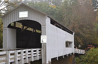
Lake Creek is a major tributary of the Siuslaw River in Lane County in the U.S. state of Oregon. On average, the 40-mile (64 km) long creek contributes about a third of the lower Siuslaw's water volume.

Bear Creek is a tributary of the Salmon River in the Central Oregon Coast Range in the United States. It begins in the Siuslaw National Forest and flows generally northwest through Lincoln County to meet the river between Rose Lodge and Otis. Named tributaries from source to mouth are McMullen, Tarry, Southman, and Morton creeks.

Cavitt Creek is a tributary of the Little River in Douglas County in the U.S. state of Oregon. From its source near Red Butte, the creek flows generally west then north through the Umpqua National Forest of the Cascade Range before entering the river about 1.5 miles (2.4 km) upstream of the rural community of Peel and 7 miles (11 km) above the Little River's mouth on the North Umpqua River.

Lost Creek is a tributary of the Middle Fork Willamette River in the U.S. state of Oregon. It begins in the Cascade Range foothills between Dorena Lake and Lookout Point Lake and flows generally north to meet the river downstream of Lowell. Along the way, it passes by the rural community of Dexter, then under Oregon Route 58, and through part of Elijah Bristow State Park. Named tributaries of Lost Creek from source to mouth are Guiley, Gossage, Carr, Middle, Anthony, and Wagner creeks.

Horse Creek is a tributary of the McKenzie River in near the unincorporated community of McKenzie Bridge in Lane County in the U.S. state of Oregon. It begins in the Cascade Range in the Three Sisters Wilderness of the Willamette National Forest. Its headwaters are near the Deschutes County border and the Pacific Crest Trail. It flows generally northwest to meet the river about 65 miles (105 km) upstream of the McKenzie's confluence with the Willamette River.

