
Linslade is a town in civil parish of Leighton-Linslade, in the Central Bedfordshire unitary authority area of Bedfordshire, England. It borders the town of Leighton Buzzard. Linslade was transferred from Buckinghamshire in 1965. Before then, it was a separate urban district. It remained a part of the Diocese of Oxford until 2008 when it joined Leighton Buzzard in the Diocese of St Albans.

Campton is a village and former civil parish, now in the parish of Campton and Chicksands, in the Central Bedfordshire district of Bedfordshire, England. It is about 9 miles (14 km) south of Bedford, and is about 9 miles (14 km) north-west from Letchworth and sits on a tributary of the River Ivel. It is just to the west of Shefford. The 13th century Church of All Saints is in the centre of the village. In 1961 the parish had a population of 358.

Wootton is a large village and civil parish located to the south-west of Bedford, in the north of Bedfordshire, England. The parish also includes the hamlets of Hall End, Keeley Green and Wootton Green.

Abenhall is a small village and former civil parish, now in the parish of Mitcheldean, in the Forest of Dean district, in the county of Gloucestershire, England. It lies on the road between Mitcheldean and Flaxley in the Forest of Dean. The parish included the settlement of Plump Hill, which is actually more populous than Abenhall itself, and was once part of the Hundred of St Briavels. Originally a mining and iron-making centre like much of the surrounding area, the village is notable for its 14th century Church of St Michael, which is built of local red sandstone and has ornate contemporary carvings relating to the Forest of Dean's principal industries. These include a shield bearing the arms of the Freeminers on the west wall and a mid-15th century octagonal font, that has tools of miners and metalworkers incised on its sides. Abenhall is a tiny, ancient village in a secluded quiet valley near Mitcheldean. The parish includes the settlement of Plump Hill, on the Mitcheldean to Cinderford Road as it climbs into the high Forest. Abenhall is on the Flaxley to Mitcheldean Road. Originally a mining and iron making centre, it is notable for its 14th century Church of St Michael, which is built of local red sandstone and has excellent contemporary carvings relating to the Forest of Dean's industries. These include a shield bearing the arms of the Freeminers on the west wall and the fabulous mid-15th century octagonal font, that has tools of miners and metalworkers incised on its sides. In the west tower is a spectacular new window installed 14 April 2011 by stained glass artist Thomas Denny; presented by the current free miners of the Forest of Dean to represent their gratitude and present day continuation of the ancient local customs of coal, iron ore and stone mining. In 1931 the parish had a population of 230.
Bolnhurst is a small village and former civil parish, now in the parish of Bolnhurst and Keysoe, in the Borough of Bedford, Bedfordshire, England. The village is about 6 miles (9.7 km) north-northeast of Bedford town centre and about 6 miles (10 km) west of St Neots. In 1931 the parish had a population of 162.

Chicksands is a village and former civil parish, now in the parish of Campton and Chicksands in the Central Bedfordshire district of Bedfordshire, England. The village is on the River Flit and close to its parish village of Campton and the town of Shefford.

Carlton is a village and former civil parish, now in the parish of Carlton and Chellington, in the Bedford district, in the ceremonial county of Bedfordshire, England. The River Great Ouse runs just to the north of the village. Nearby places are Chellington, Harrold, Pavenham, Turvey, Lavendon and Odell. In 1931 the parish had a population of 340.

Dean and Shelton is a civil parish in the Bedford district, in the ceremonial county of Bedfordshire, England.

West Newton is a village and former civil parish, now in the parish of Sandringham, in the King's Lynn and West Norfolk district, in the north of the county of Norfolk, England. The village is 1 kilometre (0.62 mi) south of Sandringham, 11 kilometres (7 mi) north of the town of King's Lynn and 60 kilometres (37 mi) north-west of the city of Norwich. In 1931 the parish had a population of 198.
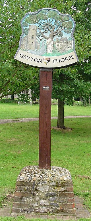
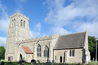
Gayton Thorpe is a village and former civil parish, now in the parish of Gayton, in the King's Lynn and West Norfolk district, in the county of Norfolk, England. The village is located 7.1 miles (11.4 km) south-east of King's Lynn and 31 miles (50 km) north-west of Norwich. In 1931 the parish had a population of 136.

Tatterford is a village and former civil parish, now in the parish of Tattersett, in the North Norfolk district, in the county of Norfolk, England. The village is 4.8 miles south west of the town of Fakenham, 30.3 miles north west of Norwich and 112 miles north north east of London. The nearest railway station is at Sheringham for the Bittern Line which runs between Sheringham, Cromer and Norwich. The nearest airport is Norwich International Airport. In 1931 the parish had a population of 66.
Yelden or Yielden is a village and former civil parish, now in the parish of Melchbourne and Yielden, in the Bedford district, in the ceremonial county of Bedfordshire, England, near the borders with Northamptonshire and Cambridgeshire. It lies on the River Til which feeds into the Great Ouse valley and is about 70 m (230 ft) above sea level. It is approximately 14 miles (23 km) north of Bedford, 3.75 miles (6.04 km) south-east of Higham Ferrers and 6.75 miles (10.86 km) west of Kimbolton and is in the Hundred of Stodden. The countryside around the village rises to about 90 m (300 ft) above sea level, is generally open and rolling in nature and is predominantly used for agricultural purposes. The centre piece of the village is the Castle Mound or Yielden Castle the site of a Norman motte-and-bailey castle. This is now a complex of grassed over earthworks dominated by a central mound. Other notable features include the church of St Mary, a Wesleyan Chapel built in 1884, the Chequers Public House and the Yelden Village Hall. It has a present population of roughly between 150 and 200 adults and between 50 and 100 children living in about 90 residences.

Chellington is a village and former civil parish, now in the parish of Carlton and Chellington, in the Bedford district, in the ceremonial county of Bedfordshire, England, situated approximately 7 miles (11 km) north-west of Bedford town centre. In 1931 the parish had a population of 78.

Husborne Crawley is a small village and civil parish in Bedfordshire, England, located close to Junction 13 of the M1 motorway. The village touches the borders of the Woburn Abbey estate on one side, and the village of Aspley Guise on the other. The meaning of the Husborne element of the towns name is "warrior stream" and the Crawley element means "crow clearing". It appears as Hussheburn Crawele, in 1421.

Knotting is a village and former civil parish, now in the parish of Knotting and Souldrop, in the Bedford district, in the ceremonial county of Bedfordshire, located near the border with Northamptonshire. Nearby places are, Sharnbrook, Podington, Odell, Melchbourne, Yelden, Newton Bromswold, Souldrop and Rushden over the border in Northamptonshire. In 1931 the parish had a population of 114. On 1 April 1934 the parish was abolished to form "Knotting and Souldrop".

Ousden is a village and civil parish in the West Suffolk district of Suffolk in eastern England. It is located around six miles west of Bury St Edmunds and 72 miles north of London, and as of 2011, its population is 266. The village has an Anglican church of St Peter's and a chapel in the cemetery dedicated to St Barnabas.

Hulcote is a village and a former civil parish, now in the parish of Hulcote and Salford, in the Central Bedfordshire district of the ceremonial county of Bedfordshire, England. In 1931 the parish had a population of 39.

Upper Gravenhurst is a village and former civil parish, now in the parish of Gravenhurst, in the Central Bedfordshire district of the ceremonial county of Bedfordshire, England. In 1881 the parish had a population of 354. On 24 March 1888 the parish was abolished and merged with Lower Gravenhurst to form "Gravenhurst".
Shelton is a village and former civil parish, now in the parish of Dean and Shelton, in the Bedford district, in the ceremonial county of Bedfordshire, England. In 1931 the parish had a population of 101. On 1 April 1934 the parish was abolished and merged with Dean to form "Dean and Shelton".

Upton is a village and former civil parish, now in the parish of Upton and Coppingford, in the Huntingdonshire district, in the county of Cambridgeshire, England. It is near Coppingford north west of Huntingdon. In 1931 the parish had a population of 109. Upton has a church called St Margaret's Church which is grade II* listed.


