Debalgarh

Last updated
Debalgarh
West Bengal relief map.svg
Archaeological site icon (red).svg
Shown within West Bengal
LocationDebagram, West Bengal, India
Coordinates 23°09′30″N88°39′32″E / 23.1584422°N 88.6589176°E / 23.1584422; 88.6589176
TypeSettlement
Length1 kilometre (0.62 mi)
Width1 kilometre (0.62 mi)
Site notes
ConditionRuins
OwnershipPublic
Public accessYes

Debalgarh is an archaeological site located at Debagram Anulia village in Nadia district of West Bengal, India. [1] [2] Post-Gupta, Pala, Sena and Sultanate period artefacts have been recovered from the archaeological site, [3] which representing an estimated 1500 years of history of the settlement. Debalgarh is believed to have been a trading center during the Sena period; [4] [5] Artistic excellence is observed in the pottery of this period. [6]

Contents

The archaeological site is spread over an area of 1 square kilometre (0.39 sq mi); the roughly square archeological site is both about 1 km long in length and width. [7] The remains of a wide wall built of mud and bricks, which was 15 feet to 20 feet wide, are observed around this mean. On the outer side of the wall was a moat 40–50 meters wide and 8–10 feet deep, much of which has now disappeared. [8]

Excavation work has not been conducted by any government agency here. However, black-red pottery, [3] Jol pradīpa (A type of lamp), Buddhist and Vishnu idols [9] have been discovered from the archaeological site. [1] [6]

Location

Debalgarh is located in the Northern Hemisphere, 23.158 degrees north of the Equator. Located in Debagram in Nadia district, West Bengal on the Ganges delta about 75 kilometres (47 mi) from Kolkata. [10]

Debalgarh is situated on the banks of the Hangor river, a branch of the Moralee river; at present the river is silted up and has become a bill or swamp called Nastar Bill [11] [12] . [13] The archaeological site was located on the south bank of the river, and the connection with the Bhagirathi, a distributary of the Ganges, and the Ichamati, along with the river navigability, provided commercial potential. [14]

History

The first mention of Debalgarh archaeological site is found in the book List of Ancient Monuments in Bengal published in 1896. The book described Debalgarh as an archaeological site of the Pala-Sena period before the Muslim era. Apart from this, Debalgarh was mentioned in a Bengali newspaper Samachar Darpan in an article titled cākadā ha'itē ēta krōśa dūrē ēkaṭi iṭēra bhāṅā stupa dēkhā yāẏa (in english: A broken mound of bricks is seen so far from Chakda). [15]

Chronology

According to the sample obtained, the duration of Dealgarh has been divided into four Phases by The Asiatic Society. The first layer (Phase) belongs to the modern age, at this layer, a sign of British colonial rule has been found. The silver coins and remains of weapon were recovered in the second layer (Phase), indicating the Sultanate and the Mughal era. The third layer belonged to the Pala and Sena era, and at this layer pottery and Buddha statues were found. The lowest layer belongs to the beginning period early Middle Age. At this layer the archaeological materials of post-Gupta and Pala era have been discovered, such as metal Buddha idols and the Dharmachakra. [3]

StagesDatesEvents [3]
Stage IModern ageBritish colonial rule
Stage II1200–1750  AD Sultanate and Mughal era
Stage IIIEarly Middle Age Pala and Sena era
Stage IVEarly Middle AgePost-Gupta and Pala

Site

The archaeological site roughly consists of a moated fort, outer fort area and the river bed of Hangor river. [16]

The fort

The fort was surrounded by a deep moat about 40 meters to 50 meters wide. Today, most of the moat has disappeared, but several sections are still 8 feets to 10 feets deep. The fort was protected by a rampart on the inside of the moat. The rampart (wall) was built of mud and bricks. The width of the rampart was from 15 feet to 20 feet. At the four corners of the fort were four earthen watchtowers. However, among the four watchtowers, the one in the north-west corner watchtower survives, the other three have been destroyed. The present height of the north-west corner watchtower is 60 feet and its foundation is spread over an area of 3 acres. It is estimated that the watchtowers were 150–200 feet high before erosion and destruction. [8]

At the center of the fort is a large pond, known as Debala or Rajar pukur. The width of the pond is 420 feet from east to west and 380 feet from north to south. Three parallel walls, ghats and a series of vast chambers were discovered on the western bank of the pond, while excavation work was underway under the Mahatma Gandhi National Rural Employment Guarantee Act, 2005 (MGNREGA). The parallel walls are about 150 feet long and spaced 30 feet apart. A similar large structure was discovered on the south bank of the pond during agricultural land expansion in 2016. Presumably there was a palace centered around the pond. [17]

Outer area of the fort

This part is located in the northern side of the moat. The part is covered by Debagram Reserve Forest. There are several mounds, situated on the banks of two water bodies known as Nal-pukur and Sagardighi. A mound lies between the Nal-pukur and the watchtower of the fort, which has a height of 10 feet to 12 feet and a length of 50 feet to 60 feet and a width of 40 feet to 50 feet. The possibility of well-planned urban remains beneath these mounds has been pointed out by Prof. Biswajit Roy. It is assumed that the settlement extended to the north-west. A pattern of alleyways can be observed within the settlement. [18]

The river bed of Hangor river

An abandoned riverbed is observed on the north-east side of the fort, known as Nastar Bill. It was formerly known as the Hangor river, which is actually a branch of the Moralee river. Various artefacts have been recovered from this riverbed. [19]

Archaeology

The archaeological site has Debagram from medieval times in the form of ruins. This site is known to the villagers as the palace or residence of Debal Raja, and the villagers believe that the site has been abandoned since the death of Debal Raja. [6] Ancient artefacts have been found from this place and its surrounding areas. [1]

The Asiatic Society mentioned in the monthly bulletin published in July 2018, the presence of Debalgarh in the Pala era. [1] Many artifacts have been recovered by the locals, which are preserved in the Debagram Museum. Professor Biswajit Roy identified the archaeological site as a fort. Anchor stones and gold and silver coins recovered at Debalgarh bear the indications of a trading centre. Besides, the anchor stones indicate the presence of naval-trade system and navigable waterways at Devalgarh.

Artifacts

Pottery

Engraved vessel fragments of Sena period recovered from Debalgarh. deblgdd' theke uddhaarkRt senyuger u[?]kiirnn mR[?]paatrer ttukr smuuh.jpg
Engraved vessel fragments of Sena period recovered from Debalgarh.

Black colored smooth pottery has been found from Debalgarh; Some black colored pottery has been found, on which ornamentation is observed. Brightly colored pottery and narrow tubular pitchers from the Sultanate period have been discovered. All these artefacts indicate the advanced pottery of Debalgarh during the Sen and Sultanate periods. An decorative vase of the Pala period, with a female figure inscribed on the stem, was recovered. [20] This decorative vase represents the advanced art of Bengal during the Pala period. [20]

Anchor stone

3 cm perforated stone block were recovered from the Khirki pond and the moat at Debalgarh. Professor Biswajit Roy, referred to these stone blocks as anchor stone of ships or vessels. [14] He also mentioned that such stone blocks were also discovered from Harinarayanpur and Tilpi archaeological sites, which were used for anchoring. [12] [14]

Seals and coins

The terracotta seals found in the archaeological site are circular and inscribed with the image of a lotus flower, the lotus having eight petals. Gold coins of the Gupta period and silver coins of the Sultanate period have been found. The silver coin is identified as a coin of the Sultanate era by the inscribed lettering on both sides.

Decorated bricks and other patterns

Large and medium sized bricks were found. Large bricks are 18 inches long, 12 inches wide and 2-2.5 inches thick (18 inches x 12 inches x 2-2.5 inches) and on the other hand medium sized bricks are 11 inches long, 7-8 inches wide and 1-1.5 inches thick (11 inches x 7-8 inches x 1-1.5 inches). Besides, decorative bricks with foliage carved and some decorated panels were found. Various sizes of terracotta ornaments and semi-precious stone beads, pottery with fishtail handles and terracotta animal replicas have been found. [21]

Also some large size stone blocks have been recovered from different places of Debagram. The ornamentation inscribed on these large stone blocks suggests that they were used as architectural materials. [22]

Related Research Articles

<span class="mw-page-title-main">Gangaikonda Cholapuram</span> Town in Tamil Nadu, India

Gaṅgaikoṇḍa Chōḻapuram is a village located near to Jayankondam, Ariyalur district, Tamil Nadu, India. It became the capital of the Chola dynasty in c. 1025 by Chola emperor Rajendra I, and served as the capital for around 250 years.

<span class="mw-page-title-main">Mahasthangarh</span> Archaeological site of Bangladesh

Mahasthangarh is one of the earliest urban archaeological sites discovered thus far in Bangladesh. The village Mahasthan in Shibganj upazila of Bogra District contains the remains of an ancient city which was called Pundranagara or Paundravardhanapura in the territory of Pundravardhana. A limestone slab bearing six lines in Prakrit in Brahmi script recording a land grant, discovered in 1931, dates Mahasthangarh to at least the 3rd century BCE. It was an important city under the Maurya Empire. The fortified area was in use until the 8th century CE.

<span class="mw-page-title-main">Naogaon District</span> District of Bangladesh in Rajshahi Division

Naogaon District is a district in northern Bangladesh, part of the Rajshahi Division. It is named after its headquarters, the city of Naogaon in Naogaon Sadar Upazila.
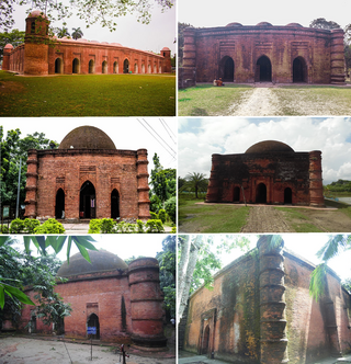
<span class="mw-page-title-main">Gauḍa (city)</span> Ancient city in India and Bangladesh

Gauḍa is a historic city of Bengal in the eastern part of the Indian subcontinent, and one of the most prominent capitals of classical and medieval India, being the capital city of Bengal under several kingdoms. The Gauḍa region was also a province of several pan-Indian empires. During the seventh century, the Gour Kingdom was founded by King Shashanka, whose reign corresponds with the beginning of the Bengali calendar. Gour gradually became synonymous with Bengal and Bengalis. It was conquered by Bakhtiyar Khalji, a lieutenant of the Ghurid ruler Muhammad of Ghori in 1203.

<span class="mw-page-title-main">Barisal</span> City in Barisal Division, Bangladesh

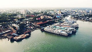
Barisal, officially known as Barishal, is a major city that lies on the banks of the Kirtankhola river in south-central Bangladesh. It is the largest city and the administrative headquarter of both Barisal District and Barisal Division. It is one of the oldest municipalities and river ports of the country. The city was once called the Venice of the East or the Venice of Bengal.

<span class="mw-page-title-main">Architecture of Bengal</span> Overview of architecture in the Bengal region of South Asia

The Architecture of Bengal, which comprises the modern country of Bangladesh and the Indian states of West Bengal, Tripura and Assam's Barak Valley, has a long and rich history, blending indigenous elements from the Indian subcontinent, with influences from different parts of the world. Bengali architecture includes ancient urban architecture, religious architecture, rural vernacular architecture, colonial townhouses and country houses and modern urban styles. The bungalow style is a notable architectural export of Bengal. The corner towers of Bengali religious buildings were replicated in medieval Southeast Asia. Bengali curved roofs, suitable for the very heavy rains, were adopted into a distinct local style of Indo-Islamic architecture, and used decoratively elsewhere in north India in Mughal architecture.

<span class="mw-page-title-main">Wari-Bateshwar ruins</span> Archaeological site in Bangladesh

The Wari-Bateshwar ruins in Narsingdi, Dhaka Division, Bangladesh is one of the oldest urban archaeological sites in Bangladesh. Excavation in the site unearthed a fortified urban center, paved roads and suburban dwelling. The site was primarily occupied during the Iron Age, from 400 to 100 BCE, as evidenced by the abundance of punch-marked coins and Northern Black Polished Ware (NBPW) artifacts.

<span class="mw-page-title-main">Burrough Hill</span>

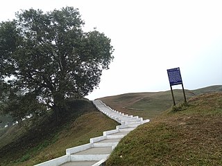
Burrough Hill is an Iron Age hillfort in Burrough on the Hill, 7 miles (11 km) south of Melton Mowbray in the English county of Leicestershire. Situated on a promontory about 210 metres (690 ft) above sea level, the site commands views over the surrounding countryside for miles around. There has been human activity in the area since at least the Mesolithic, and the hillfort was founded in the early Iron Age. In the medieval period, after the hillfort was abandoned, the hill was used as farmland. This ended in the 17th century when the parish the hill was in was enclosed. Traces of ridge and furrow show where the medieval fields were ploughed. Since the 1930s the site has been the subject of archaeological investigations and renewed excavations under the auspices of the University of Leicester began in 2010. Part of Burrough Hill Country Park and open to the public, the hillfort is protected as a Scheduled Ancient Monument.

<span class="mw-page-title-main">Unguja Ukuu</span> National Historic Site of Tanzania

Unguja Ukuu is a historic Swahili settlement on Unguja island, in Zanzibar, Tanzania.

<span class="mw-page-title-main">Kurumbera Fort</span>

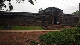
The Kurumbera Fort is a medieval fort situated in Gaganeshwar village, southeast of Keshiari, at about four kilometres from that town. The fort has small quarters and temples. It is a protected monument under the Archaeological Survey of India.

<span class="mw-page-title-main">Sriwijaya Kingdom Archaeological Park</span> Archaeological park in South Sumatra, Indonesia

Srivijaya archaeological park, formerly known as Karanganyar archaeological site, is the ancient remnants of a garden and habitation area near the northern bank of Musi river within Palembang vicinity, South Sumatra, Indonesia. Remnants of ancient man-made canals, moats, ponds and artificial islands discovered in this area suggests the site was related with a 9th-century settlement related to the Srivijaya empire. Several artifacts, such as Buddhist statues, beads, pottery and Chinese ceramics were found in this area, confirming the area was once a dense human habitation.

<span class="mw-page-title-main">Tel Michal</span>

Tel Michal is an archaeological site on Israel's central Mediterranean coast, near the modern city of Herzliya, about 6.5 kilometres (4.0 mi) north of the Yarkon River estuary and 4 kilometres (2.5 mi) south of Arsuf-Appolonia. Excavations have yielded remains from the Middle Bronze Age to the Early Arab period.

<span class="mw-page-title-main">Bhitargarh</span> Archaeological site in Bangladesh

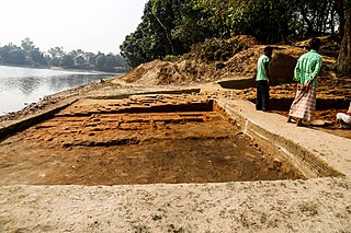
Bhitargarh is an archaeological site that includes the remains of an ancient fort city built in and around the 5th century AD. It is located in Panchagarh District in Rangpur Division in the northern part of Bangladesh and is large enough that it can be seen from space. The archaeological significance of the site lies in its strategic position as an intersection of the trade routes between Tibet, Nepal, Bhutan and the middle and lower Ganges Valley. At its height the city stretched over 5 km by 3 km and involved rerouting the Talma River.

<span class="mw-page-title-main">Warangal Fort</span> Building in Telangana, India

Warangal Fort is located in Warangal District, Telangana, India. It was the capital city of Kakatiya dynasty and the Musunuri Nayakas. It appears to have existed since at least the 12th century when it was the capital of the Kakatiyas. The fort has four ornamental gates, known as Kakatiya Kala Thoranam, that originally formed the entrances to a now ruined great Shiva temple. The Kakatiyan arch has been adopted and officially incorporated into the emblem of Telanganaafter the bifurcation of Andhra Pradesh. The fort is included in the "tentative list" of UNESCO World Heritage Site and was submitted by the Permanent Delegation of India to UNESCO on 10/09/2010.

<span class="mw-page-title-main">Pundranagar</span> Also named as Paharpur

Pundranagar in Paundrabhukti was the most important city in the ancient Bengal region, now identified with the current site of Mahasthan, located in Bogra, Bangladesh. It was a vibrant administrative, religious and cultural centre from the 3rd century BC to the 12th century AD that is from the Maurya Empire time to the Sena dynasty period. Archaeological remains and literary descriptions speak of a truly planned and magnificent city. City walls, elaborate gates, palaces, common dwellings, assembly halls, temples, viharas, shops, ponds and even suburban temples and viharas characterised the city; Chinese pilgrim, Xuanzang, visiting in the 7th century AD, particularly mentions ponds, orchards, flowers and pleasure gardens.

<span class="mw-page-title-main">Gomsi</span>

Gomsi is an ancient archaeological site located between Rani Village and Sika Tode in East Siang District, Arunachal Pradesh, India. It is dated to the 13th-14th century by the Directorate of Research, Government of Arunachal Pradesh and is associated with the Chutia Kingdom. It is located at the field of Rani Village, about 15 km from the town of Pasighat.

The Kasturi Rangappa Nayaka Fort in Sira in Tumkur district of Karnataka is named after the Nayaka ruler Kasturi Rangappa Nayaka, who had ruled over Sira in the early 17th century as a palegar under the Vijayanagar Empire. After their rule, the fort and the Province of Sira came under the control of several rulers. Restoration works have been carried out by the Archaeology Department of Karnataka.

Bambata Cave is one of the Southern Africa prehistoric sites situated in Motobo National Park along with Inanke, Nswatugi, Pomengwe and Silozwane caves in Zimbabwe.

The Fisher Mound Group is a group of burial mounds with an associated village site located on the DesPlaines River near its convergence with the Kankakee River where they combine to form the Illinois River, in Will County, Illinois, about 60 miles southwest of Chicago. It is a multi-component stratified site representing several Prehistoric Upper Mississippian occupations as well as minor Late Woodland and Early Historic components.

<span class="mw-page-title-main">Rajpat</span> Archaeological site in West Bengal, India

Rajpat or Kamtapur Fort is an archaeological site in present-day Gosanimari in the Dinhata I CD block in the Dinhata subdivision of the Cooch Behar district in West Bengal, India.

References

  1. 1 2 3 4 "Volume XLVII No. 7" (PDF). The Asiatic Society. 1 Park Street, Kolkata: The Asiatic Society. July 2018. p. 9. Retrieved 1 December 2023.{{cite web}}: CS1 maint: location (link)
  2. Prohor. "উদ্ধার রোমান পানপাত্র, গুপ্তযুগের মুদ্রা; নদীয়ার দেবলগড়ের ইতিহাস সংরক্ষণ বিশ্বজিৎ রায়ের - Prohor". উদ্ধার রোমান পানপাত্র, গুপ্তযুগের মুদ্রা; নদীয়ার দেবলগড়ের ইতিহাস সংরক্ষণ বিশ্বজিৎ রায়ের - Prohor. Retrieved 2023-12-15.
  3. 1 2 3 4 Roy 2021, p. 20.
  4. Roy 2021, p. 48.
  5. Roy 2021, p. 133.
  6. 1 2 3 Chattopadhyay, Kuntak (11 Jun 2023). "দেবল রাজার গড়". Anandabazar Patrika (in Bengali). ABP Pvt. Ltd. Retrieved 2 December 2023.
  7. Roy 2021, p. 116.
  8. 1 2 Roy 2021, pp. 52–53.
  9. Roy 2021, p. 20–21.
  10. Basu 2021, p. 167.
  11. Roy 2021, p. 36.
  12. 1 2 Roy 2021, p. 117.
  13. Roy 2021, p. 35.
  14. 1 2 3 Roy 2021, p. 61.
  15. Bhattacharya, Tanmay (7 April 2023). "ঈর্ষাক্ষাৎকার: বিশ্বজিৎ রায় — দ্বিতীয় পর্ব". Prohor (in Bengali). Retrieved 10 December 2023.
  16. Roy 2021, pp. 52 and 60.
  17. Roy 2021, pp. 53–54.
  18. Roy 2021, p. 60.
  19. Roy 2021, pp. 60–61.
  20. 1 2 Roy 2021, p. 83.
  21. Roy 2021, pp. 54–55.
  22. Roy 2021, p. 56.

Bibliography